TopoQuest Logo
Do you find TopoQuest useful?
Help keep TopoQuest running and adding new maps/features by donating!
Bitcoin:  19c7KJd3qBynnjoSw5npx9KScwjBe4ifkT
Litecoin:  LXs6TkuXGGXo1vDsWCkWVdjQX94eUKd6ui
Home View Maps Find Maps Find Places Resources & Links


McWilliams, Alabama Topographic Map

USGS Map Title: McWilliams, AL
USGS Map MRC: 31087G1
DRG (GeoTIFF) Download: o31087g1.tif


Neighboring USGS Topographic Map Quads:


  Rosebud, AL  
31087H2
 

  Oak Hill, AL  
31087H1
 

  Pine Apple North, AL  
31086H8
 

  Nadawah, AL  
31087G2
 

  McWilliams, AL  
31087G1
 

  Pine Apple South, AL  
31086G8
 

  Beatrice, AL  
31087F2
 

  Skinnerton, AL  
31087F1
 

  Bethel, AL  
31086F8


Map MRC Location:

N32°
W88°
N32°
W87°
H8 H7 H6 H5 H4 H3 H2 H1
G8 G7 G6 G5 G4 G3 G2 G1
F8 F7 F6 F5 F4 F3 F2 F1
E8 E7 E6 E5 E4 E3 E2 E1
D8 D7 D6 D5 D4 D3 D2 D1
C8 C7 C6 C5 C4 C3 C2 C1
B8 B7 B6 B5 B4 B3 B2 B1
A8 A7 A6 A5 A4 A3 A2 A1
N31°
W88°
N31°
W87°

McWilliams, AL USGS 1:24K Topographic Map Preview:
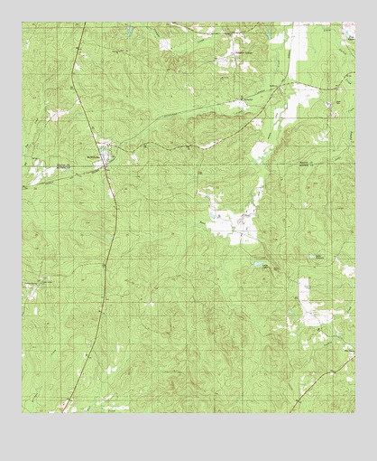
McWilliams, AL USGS Topographic Map
Click on map above to begin viewing in our Map Viewer.

This topographic map contains these locations and features:
Feature Name Type Latitude Longitude GNIS ID View Map
Antioch Church (historical)ChurchN31.7813°W87.1247°136480View Map
Barles School (historical)SchoolN31.8027°W87.0922°136482View Map
Beard CemeteryCemeteryN31.8493°W87.0075°138424View Map
Box Hill Church (historical)ChurchN31.8115°W87.0492°136493View Map
Brantley Gin (historical)LocaleN31.7893°W87.1158°136494View Map
Chapman Mill (historical)LocaleN31.7621°W87.0822°136499View Map
Emmanuel Church (historical)ChurchN31.7738°W87.0969°136513View Map
Grimes CemeteryCemeteryN31.7865°W87.0939°136531View Map
Grindstone CreekStreamN31.8596°W87.0297°138476View Map
Hopewell ChurchChurchN31.8657°W87.0872°163231View Map
HughesLocaleN31.7974°W87.0936°136539View Map
Indian Springs Baptist ChurchChurchN31.7918°W87.1178°136541View Map
Lake JaneReservoirN31.7980°W87.0363°154128View Map
Lake PatrickReservoirN31.8001°W87.0164°136599View Map
Mack Mcclurkin DamDamN31.8652°W87.0783°130001View Map
Mcclurkin LakeReservoirN31.8652°W87.0783°130000View Map
Mcgowin Pond DamDamN31.7985°W87.0383°129971View Map
McWilliamsPopulated PlaceN31.8310°W87.0939°122607View Map
McWilliams ChurchChurchN31.8235°W87.0922°154579View Map
McWilliams ChurchChurchN31.8340°W87.0922°138515View Map
McWilliams ChurchChurchN31.8329°W87.0914°138516View Map
McWilliams Post OfficePost OfficeN31.8319°W87.0923°167554View Map
Mount Canaan ChurchChurchN31.8568°W87.0505°138528View Map
Mount Olive ChurchChurchN31.8702°W87.0464°138530View Map
Old TexasPopulated PlaceN31.7696°W87.0003°136590View Map
Owens Mill (historical)LocaleN31.8071°W87.0930°136597View Map
Pineview CemeteryCemeteryN31.8326°W87.0911°138554View Map
Pudding SwampSwampN31.7910°W87.0680°136613View Map
RutthvenPopulated PlaceN31.8535°W87.0297°157004View Map
Saint John ChurchChurchN31.8282°W87.0933°136623View Map
SchusterPopulated PlaceN31.8640°W87.0469°157024View Map

Note: Coordinates in the location and feature list above are referenced to NAD83 datum.


Copyright (C) 2008-2025 Ryan Niemi / Sunset Dynamics ... All Rights Reserved