TopoQuest Logo
Do you find TopoQuest useful?
Help keep TopoQuest running and adding new maps/features by donating!
Bitcoin:  19c7KJd3qBynnjoSw5npx9KScwjBe4ifkT
Litecoin:  LXs6TkuXGGXo1vDsWCkWVdjQX94eUKd6ui
Home View Maps Find Maps Find Places Resources & Links


Meadow Creek, West Virginia Topographic Map

USGS Map Title: Meadow Creek, WV
USGS Map MRC: 37080G8
DRG (GeoTIFF) Download: o37080g8.tif


Neighboring USGS Topographic Map Quads:


  Thurmond, WV  
37081H1
 

  Danese, WV  
37080H8
 

  Rainelle, WV  
37080H7
 

  Prince, WV  
37081G1
 

  Meadow Creek, WV  
37080G8
 

  Meadow Bridge, WV  
37080G7
 

  Shady Spring, WV  
37081F1
 

  Hinton, WV  
37080F8
 

  Talcott, WV  
37080F7


Map MRC Location:

N38°
W81°
N38°
W80°
H8 H7 H6 H5 H4 H3 H2 H1
G8 G7 G6 G5 G4 G3 G2 G1
F8 F7 F6 F5 F4 F3 F2 F1
E8 E7 E6 E5 E4 E3 E2 E1
D8 D7 D6 D5 D4 D3 D2 D1
C8 C7 C6 C5 C4 C3 C2 C1
B8 B7 B6 B5 B4 B3 B2 B1
A8 A7 A6 A5 A4 A3 A2 A1
N37°
W81°
N37°
W80°

Meadow Creek, WV USGS 1:24K Topographic Map Preview:
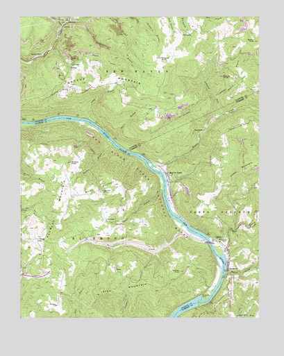
Meadow Creek, WV USGS Topographic Map
Click on map above to begin viewing in our Map Viewer.

This topographic map contains these locations and features:
Feature Name Type Latitude Longitude GNIS ID View Map
AbrahamPopulated PlaceN37.7907°W80.9551°1553688View Map
Abraham Post OfficePost OfficeN37.7904°W80.9548°1742653View Map
BackusPopulated PlaceN37.8543°W80.9748°1553774View Map
Backus MountainSummitN37.8413°W80.9227°1535107View Map
Beelick BranchStreamN37.8418°W80.8981°1535573View Map
Beelick KnobSummitN37.8649°W80.8772°1535575View Map
BeurytownPopulated PlaceN37.8273°W80.9051°1553881View Map
BraggPopulated PlaceN37.7823°W80.9904°1536293View Map
Bragg School (historical)SchoolN37.7771°W80.9901°1742688View Map
Camp BranchStreamN37.8323°W80.9648°1536895View Map
Cheney KnobSummitN37.8504°W80.8937°1537232View Map
Chestnut Knob ForkStreamN37.8737°W80.9743°1537284View Map
Coles School (historical)SchoolN37.7596°W80.8898°1556906View Map
Davis BranchStreamN37.8243°W80.9520°1538022View Map
DillonPopulated PlaceN37.7704°W80.9506°1554303View Map
Eburnean School (historical)SchoolN37.8632°W80.8956°1556080View Map
Farleys CreekStreamN37.7890°W80.9154°1538901View Map
First Baptist ChurchChurchN37.8104°W80.9229°1558039View Map
Glendale School (historical)SchoolN37.8573°W80.9740°1539464View Map
Goddard CemeteryCemeteryN37.8579°W80.9268°2586244View Map
Goddard KnobSummitN37.8584°W80.9283°1554577View Map
Goodson CemeteryCemeteryN37.7876°W80.9600°2586361View Map
Green Sulphur District Volunteer Fire DepartmentBuildingN37.7735°W80.8915°2577705View Map
Harrah CemeteryCemeteryN37.8459°W80.9656°1540002View Map
Harrah School (historical)SchoolN37.8468°W80.9579°1556116View Map
HemlockPopulated PlaceN37.8737°W80.9745°1540135View Map
Hump MountainSummitN37.8134°W80.8776°1540578View Map
Interchange 133CrossingN37.7679°W80.9873°1742803View Map
Interchange 139CrossingN37.7801°W80.8934°1556929View Map
Irish MountainSummitN37.7598°W80.9602°1540715View Map
Irish School (historical)SchoolN37.7665°W80.9437°1742804View Map
Kincaid School (historical)SchoolN37.8437°W80.8773°1556132View Map
Laurel CreekPopulated PlaceN37.8573°W80.9937°1541399View Map
Laurel CreekStreamN37.8615°W80.9843°1541401View Map
Laurel CreekStreamN37.7698°W80.8929°1541414View Map
Laurel Creek Baptist ChurchChurchN37.7704°W80.8756°1558044View Map
LawtonPopulated PlaceN37.8712°W80.9770°1556135View Map
Lefthand Fork Meadow CreekStreamN37.8343°W80.8956°1541764View Map
Lick CreekStreamN37.7765°W80.8937°1541882View Map
Lick Creek BridgeBridgeN37.7829°W80.8905°2647443View Map
Little Laurel ChurchChurchN37.8554°W80.9731°1542140View Map
Mary Draper Ingles BridgeBridgeN37.7810°W80.9009°2647434View Map
Meadow CreekPopulated PlaceN37.8101°W80.9231°1543056View Map
Meadow CreekStreamN37.8112°W80.9268°1543057View Map
Meadow Creek Missionary Baptist ChurchChurchN37.8051°W80.9229°1558047View Map
Meadow Creek Post OfficePost OfficeN37.8064°W80.9214°1559457View Map
New Richmond (historical)Populated PlaceN37.7796°W80.8937°1556954View Map
New River Gorge National RiverParkN37.8403°W80.9897°1877618View Map
New Salem ChurchChurchN37.8023°W80.9565°1544138View Map
New Salem Church CemeteryCemeteryN37.8024°W80.9565°2586346View Map
Oak Grove ChurchChurchN37.8454°W80.9754°1544282View Map
Panther BranchStreamN37.8226°W80.9520°1544541View Map
Paynes School (historical)SchoolN37.7701°W80.8754°1556959View Map
Pear (historical)Populated PlaceN37.8010°W80.9693°1742890View Map
Plumley KnobSummitN37.8145°W80.9736°1545070View Map
Plumley MountainSummitN37.8144°W80.9736°1545071View Map
Plumley School (historical)SchoolN37.8096°W80.9768°1742906View Map
Red SpringPopulated PlaceN37.8687°W80.9162°1555455View Map
Richlick BranchStreamN37.8734°W80.9681°1545558View Map
Richman FallsFallsN37.7779°W80.8990°1556968View Map
Richmond CemeteryCemeteryN37.7832°W80.8931°1545560View Map
Richmond School (historical)SchoolN37.7551°W80.9812°1545564View Map
Richmond School (historical)SchoolN37.7629°W80.9006°1742926View Map
Saint Colmans CemeteryCemeteryN37.7659°W80.9209°1742938View Map
Saint Colmans Roman Catholic ChurchChurchN37.7660°W80.9212°1742939View Map
SandstonePopulated PlaceN37.7710°W80.8915°1546397View Map
Sandstone Elementary School (historical)SchoolN37.7823°W80.8956°1546399View Map
Sandstone FallsFallsN37.7585°W80.9054°1546398View Map
Sandstone Falls State Park (historical)ParkN37.7598°W80.9023°1742948View Map
Sandstone Missionary Baptist ChurchChurchN37.7701°W80.8912°1558055View Map
Sandstone Post OfficePost OfficeN37.7739°W80.8917°1559469View Map
Serena School (historical)SchoolN37.8623°W80.9179°1556194View Map
Sewell BranchStreamN37.8029°W80.9254°1546586View Map
Smith MountainSummitN37.8057°W80.9506°1546997View Map
Sullivan KnobSummitN37.7691°W80.9162°1547707View Map
Tank HollowValleyN37.8710°W80.9778°1547889View Map
Thomas School (historical)SchoolN37.8512°W80.9751°1559375View Map

Note: Coordinates in the location and feature list above are referenced to NAD83 datum.


Copyright (C) 2008-2024 Ryan Niemi / Sunset Dynamics ... All Rights Reserved