TopoQuest Logo
Do you find TopoQuest useful?
Help keep TopoQuest running and adding new maps/features by donating!
Bitcoin:  19c7KJd3qBynnjoSw5npx9KScwjBe4ifkT
Litecoin:  LXs6TkuXGGXo1vDsWCkWVdjQX94eUKd6ui
Home View Maps Find Maps Find Places Resources & Links


Danese, West Virginia Topographic Map

USGS Map Title: Danese, WV
USGS Map MRC: 37080H8
DRG (GeoTIFF) Download: o37080h8.tif


Neighboring USGS Topographic Map Quads:


  Fayetteville, WV  
38081A1
 

  Winona, WV  
38080A8
 

  Corliss, WV  
38080A7
 

  Thurmond, WV  
37081H1
 

  Danese, WV  
37080H8
 

  Rainelle, WV  
37080H7
 

  Prince, WV  
37081G1
 

  Meadow Creek, WV  
37080G8
 

  Meadow Bridge, WV  
37080G7


Map MRC Location:

N38°
W81°
N38°
W80°
H8 H7 H6 H5 H4 H3 H2 H1
G8 G7 G6 G5 G4 G3 G2 G1
F8 F7 F6 F5 F4 F3 F2 F1
E8 E7 E6 E5 E4 E3 E2 E1
D8 D7 D6 D5 D4 D3 D2 D1
C8 C7 C6 C5 C4 C3 C2 C1
B8 B7 B6 B5 B4 B3 B2 B1
A8 A7 A6 A5 A4 A3 A2 A1
N37°
W81°
N37°
W80°

Danese, WV USGS 1:24K Topographic Map Preview:
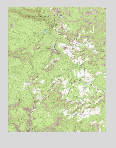
Danese, WV USGS Topographic Map
Click on map above to begin viewing in our Map Viewer.

This topographic map contains these locations and features:
Feature Name Type Latitude Longitude GNIS ID View Map
Anderson CemeteryCemeteryN37.9262°W80.9318°1534936View Map
Babcock State ParkParkN37.9940°W80.9712°1535093View Map
Babcock State Park Lake Number One DamDamN37.9768°W80.9498°1557432View Map
Bear BranchStreamN37.8798°W80.8898°1535345View Map
Bucklick BranchStreamN37.8757°W80.9551°1536608View Map
Burnt CreekStreamN37.9268°W80.9159°1536764View Map
Butler BranchStreamN37.9565°W80.9420°1536801View Map
Chesnut Knob School (historical)SchoolN37.9154°W80.9587°1556065View Map
Chestnut KnobPopulated PlaceN37.9240°W80.9751°1554123View Map
CrickmerPopulated PlaceN37.8918°W80.9062°1537821View Map
DanesePopulated PlaceN37.9307°W80.9031°1537980View Map
Danese Census Designated PlaceCensusN37.9239°W80.8997°2586796View Map
Danese Christian AcademySchoolN37.9221°W80.8922°2631489View Map
Danese Elementary SchoolSchoolN37.9415°W80.9069°2088176View Map
Danese Post OfficePost OfficeN37.9309°W80.9030°2774649View Map
Danese School (historical)SchoolN37.9418°W80.9070°1537981View Map
Danese Volunteer Fire DepartmentBuildingN37.9292°W80.9032°2578055View Map
Davis BranchStreamN37.9748°W80.9479°1538024View Map
Ebenezer School (historical)SchoolN37.9076°W80.9073°1556079View Map
Ellison BranchStreamN37.9384°W80.8865°1538681View Map
Fayette County Sheriff's Office Danese DetachmentBuildingN37.9297°W80.9032°2727915View Map
Gibson ForkStreamN37.9237°W80.9454°1556109View Map
Glade CreekStreamN37.9923°W80.9659°1539422View Map
Glade Creek Grist MillBuildingN37.9793°W80.9415°1559415View Map
Greenvalley ChurchChurchN37.9262°W80.9023°1539720View Map
Greenwood (historical)Populated PlaceN37.8787°W80.9879°1556112View Map
Greenwood MountainSummitN37.8896°W80.9840°1554613View Map
Hemlock HollowValleyN37.8783°W80.9729°1540137View Map
Hillside School (historical)SchoolN37.9812°W80.9079°1556119View Map
KathrynPopulated PlaceN37.8759°W80.9743°1556130View Map
LandisburgPopulated PlaceN37.9771°W80.9401°1554908View Map
Laurel CreekStreamN37.9676°W80.9401°1541416View Map
LaylandPopulated PlaceN37.8893°W80.9712°1554925View Map
Layland CemeteryCemeteryN37.9100°W80.9563°2586195View Map
Layland ChurchChurchN37.8998°W80.9662°1541568View Map
Layland HeightsPopulated PlaceN37.9073°W80.9598°1554926View Map
Layland Post OfficePost OfficeN37.9089°W80.9576°2774629View Map
Lick RunStreamN37.9615°W80.9031°1556139View Map
Long BranchStreamN37.9579°W80.8931°1542357View Map
Loops Road ChurchChurchN37.9165°W80.8790°1542455View Map
Mann MountainSummitN37.9091°W80.9773°1542717View Map
Mann Mountain Lookout TowerLocaleN37.9276°W80.9704°1559369View Map
MaplewoodPopulated PlaceN37.9265°W80.9331°1542742View Map
Maplewood ChurchChurchN37.9240°W80.9201°1542743View Map
Mill Brook ChurchChurchN37.8929°W80.9131°1543301View Map
Oakvale ChurchChurchN37.9421°W80.9056°1544317View Map
Pine Grove School (historical)SchoolN37.9584°W80.8926°1556175View Map
PittmanPopulated PlaceN37.9557°W80.9209°1555366View Map
Plum Grove School (historical)SchoolN37.9343°W80.9579°1556177View Map
Pole CreekStreamN37.9237°W80.8934°1559372View Map
Pond BranchStreamN37.8821°W80.9390°1545122View Map
Red Spring CreekStreamN37.8826°W80.9143°1545465View Map
Rock of Ages School (historical)SchoolN37.8912°W80.8876°1556187View Map
Sandy CreekStreamN37.9279°W80.9187°1546403View Map
Sandylick BranchStreamN37.8790°W80.9448°1546417View Map
Shades Death CreekStreamN37.9404°W80.9184°1546590View Map
Shuck CemeteryCemeteryN37.9623°W80.8945°1546754View Map
Sidenstricker BranchStreamN37.9584°W80.9443°1546765View Map
Smailes CemeteryCemeteryN37.9729°W80.9298°1546952View Map
Smoky BranchStreamN37.9382°W80.9226°1547013View Map
Terry BranchStreamN37.9190°W80.9173°1547987View Map
Walnut Flat School (historical)SchoolN37.8798°W80.8773°1556212View Map
Walnut KnobSummitN37.9044°W80.9442°1548772View Map
Walnut Knob School (historical)SchoolN37.8948°W80.9393°1556213View Map
Walnut RidgeRidgeN37.9044°W80.9442°1548774View Map
White Oak ChurchChurchN37.9626°W80.9131°1549045View Map
WSWP-TV (Grandview)TowerN37.8962°W80.9890°1559864View Map
WVPB-FM (Beckley)TowerN37.8962°W80.9890°1559759View Map
Zickafoose ChurchChurchN37.9579°W80.9190°1549484View Map

Note: Coordinates in the location and feature list above are referenced to NAD83 datum.


Copyright (C) 2008-2024 Ryan Niemi / Sunset Dynamics ... All Rights Reserved