TopoQuest Logo
Do you find TopoQuest useful?
Help keep TopoQuest running and adding new maps/features by donating!
Bitcoin:  19c7KJd3qBynnjoSw5npx9KScwjBe4ifkT
Litecoin:  LXs6TkuXGGXo1vDsWCkWVdjQX94eUKd6ui
Home View Maps Find Maps Find Places Resources & Links


Thurmond, West Virginia Topographic Map

USGS Map Title: Thurmond, WV
USGS Map MRC: 37081H1
DRG (GeoTIFF) Download: o37081h1.tif


Neighboring USGS Topographic Map Quads:


  Beckwith, WV  
38081A2
 

  Fayetteville, WV  
38081A1
 

  Winona, WV  
38080A8
 

  Oak Hill, WV  
37081H2
 

  Thurmond, WV  
37081H1
 

  Danese, WV  
37080H8
 

  Beckley, WV  
37081G2
 

  Prince, WV  
37081G1
 

  Meadow Creek, WV  
37080G8


Map MRC Location:

N38°
W82°
N38°
W81°
H8 H7 H6 H5 H4 H3 H2 H1
G8 G7 G6 G5 G4 G3 G2 G1
F8 F7 F6 F5 F4 F3 F2 F1
E8 E7 E6 E5 E4 E3 E2 E1
D8 D7 D6 D5 D4 D3 D2 D1
C8 C7 C6 C5 C4 C3 C2 C1
B8 B7 B6 B5 B4 B3 B2 B1
A8 A7 A6 A5 A4 A3 A2 A1
N37°
W82°
N37°
W81°

Thurmond, WV USGS 1:24K Topographic Map Preview:
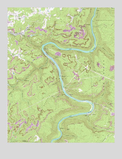
Thurmond, WV USGS Topographic Map
Click on map above to begin viewing in our Map Viewer.

This topographic map contains these locations and features:
Feature Name Type Latitude Longitude GNIS ID View Map
Alaska (historical)Populated PlaceN37.9146°W81.0393°1556047View Map
Arbuckle CreekStreamN37.9632°W81.0843°1534994View Map
Barren BranchStreamN37.9268°W81.1173°1535277View Map
BeuryPopulated PlaceN37.9596°W81.0407°1549592View Map
Beury MountainSummitN37.9282°W81.0225°1535746View Map
Big Stoney CreekStreamN37.9204°W81.0576°1535976View Map
Bobby Gardner SpringSpringN37.9004°W81.0265°1960213View Map
BowlinPopulated PlaceN37.9940°W81.1245°1556057View Map
BrooklynPopulated PlaceN37.9909°W81.0487°1553983View Map
Buffalo CreekStreamN37.9112°W81.0254°1536629View Map
Calvin ChurchChurchN37.9979°W81.0951°1536875View Map
Camp CreekStreamN37.9440°W81.0865°1536907View Map
Cedar BranchStreamN37.9332°W81.1132°1537122View Map
Cedar Branch DamDamN37.9368°W81.1232°1557434View Map
Chestnut FlatFlatN37.9796°W81.0532°1537267View Map
ClaremontPopulated PlaceN37.9182°W81.0509°1549627View Map
Coal RunReservoirN37.9849°W81.0539°1557437View Map
Coal Run Number One DamDamN37.9834°W81.0498°1557435View Map
Coal Run Number Two DamDamN37.9851°W81.0532°1557436View Map
ConchoPopulated PlaceN37.9671°W81.0879°1554181View Map
CunardPopulated PlaceN37.9987°W81.0395°1554242View Map
DimmockPopulated PlaceN37.9646°W81.0695°1554305View Map
Dowdy BluffCliffN37.8871°W81.0559°1538304View Map
Dowdy CreekStreamN37.8751°W81.0434°1538305View Map
Dunloup CreekStreamN37.9543°W81.0779°1538447View Map
East Sewell (historical)Populated PlaceN37.9829°W81.0257°1556078View Map
Ephraim CreekStreamN37.9643°W81.0209°1538731View Map
Ephram (historical)Populated PlaceN37.9090°W81.0134°1556082View Map
Erskine (historical)Populated PlaceN37.9668°W81.0809°1556083View Map
Excelsior School (historical)SchoolN37.9832°W81.0176°1556086View Map
Finlow (historical)Populated PlaceN37.9823°W81.0276°1556099View Map
Fire CreekStreamN37.9590°W81.0290°1538972View Map
Fire Creek (historical)Populated PlaceN37.9584°W81.0290°1556100View Map
Garden Ground MountainSummitN37.8982°W81.0837°1539330View Map
Garden Ground School (historical)SchoolN37.8807°W81.0918°1556104View Map
Gentry ChurchChurchN37.9554°W81.1170°1539367View Map
Gethsemane Memorial GardensCemeteryN37.9671°W81.1136°2726456View Map
Hamilton BranchStreamN37.9246°W81.1173°1539873View Map
Highland MountainSummitN37.8837°W81.0095°1540266View Map
Little Rock ChurchChurchN37.9012°W81.0262°1542198View Map
Little Stony CreekStreamN37.9329°W81.0629°1542230View Map
McKendreePopulated PlaceN37.8879°W81.0634°1549813View Map
McKendreee Public Hunting and Fishing AreaParkN37.8912°W81.0615°1556141View Map
Meadow ForkStreamN37.9437°W81.0912°1543062View Map
Meadow ForkPopulated PlaceN37.9332°W81.1043°1555094View Map
Miles School (historical)SchoolN37.9948°W81.0790°1556146View Map
MindenPopulated PlaceN37.9759°W81.1195°1555133View Map
Minden Census Designated Place (historical)CensusN37.9768°W81.1161°2586854View Map
Minden Post OfficePost OfficeN37.9753°W81.1149°2774632View Map
Mollys CreekStreamN37.9529°W81.0723°1543490View Map
NewlynPopulated PlaceN37.9443°W81.0854°1549851View Map
Pennbrook (historical)Populated PlaceN37.9659°W81.0201°1556173View Map
Plateau DistrictCivilN37.9432°W81.1097°1928338View Map
Red Ash (historical)Populated PlaceN37.9615°W81.0393°1556185View Map
RocklickPopulated PlaceN37.9812°W81.1023°1555505View Map
Rocklick CreekStreamN37.9746°W81.1070°1545991View Map
Rush RunStreamN37.9676°W81.0762°1546166View Map
Rush Run (historical)Populated PlaceN37.9646°W81.0657°1556191View Map
SalemPopulated PlaceN37.9893°W81.1154°1546279View Map
Salem ChurchChurchN37.9962°W81.0945°1546284View Map
SangerPopulated PlaceN37.9565°W81.1129°1555570View Map
SewellPopulated PlaceN37.9973°W81.0209°1555591View Map
Silo RapidsRapidsN37.9132°W81.0315°1877633View Map
Slater CreekStreamN37.9021°W81.0326°1546920View Map
Stone CliffLocaleN37.9368°W81.0623°1547452View Map
Surprise RapidsRapidsN37.9646°W81.0223°1877635View Map
Swell KnobSummitN37.9407°W81.0732°1556236View Map
ThayerPopulated PlaceN37.9012°W81.0309°1547996View Map
ThurmondPopulated PlaceN37.9615°W81.0823°1555811View Map
Thurmond BridgeBridgeN37.9558°W81.0789°2635386View Map
Town of ThurmondCivilN37.9609°W81.0797°2391444View Map
Turley BranchStreamN37.9209°W81.1209°1548377View Map

Note: Coordinates in the location and feature list above are referenced to NAD83 datum.


Copyright (C) 2008-2025 Ryan Niemi / Sunset Dynamics ... All Rights Reserved