TopoQuest Logo
Do you find TopoQuest useful?
Help keep TopoQuest running and adding new maps/features by donating!
Bitcoin:  19c7KJd3qBynnjoSw5npx9KScwjBe4ifkT
Litecoin:  LXs6TkuXGGXo1vDsWCkWVdjQX94eUKd6ui
Home View Maps Find Maps Find Places Resources & Links


Medford, Wisconsin Topographic Map

USGS Map Title: Medford, WI
USGS Map MRC: 45090B3
DRG (GeoTIFF) Download: o45090b3.tif


Neighboring USGS Topographic Map Quads:


  Mondeaux Dam, WI  
45090C4
 

  Westboro, WI  
45090C3
 

  Rib Lake, WI  
45090C2
 

  Medford NW, WI  
45090B4
 

  Medford, WI  
45090B3
 

  Rib River Lookout Tower, WI  
45090B2
 

  Medford SW, WI  
45090A4
 

  Stetsonville, WI  
45090A3
 

  Corinth, WI  
45090A2


Map MRC Location:

N46°
W91°
N46°
W90°
H8 H7 H6 H5 H4 H3 H2 H1
G8 G7 G6 G5 G4 G3 G2 G1
F8 F7 F6 F5 F4 F3 F2 F1
E8 E7 E6 E5 E4 E3 E2 E1
D8 D7 D6 D5 D4 D3 D2 D1
C8 C7 C6 C5 C4 C3 C2 C1
B8 B7 B6 B5 B4 B3 B2 B1
A8 A7 A6 A5 A4 A3 A2 A1
N45°
W91°
N45°
W90°

Medford, WI USGS 1:24K Topographic Map Preview:
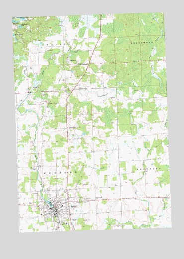
Medford, WI USGS Topographic Map
Click on map above to begin viewing in our Map Viewer.

This topographic map contains these locations and features:
Feature Name Type Latitude Longitude GNIS ID View Map
Anderson School (historical)SchoolN45.1911°W90.3740°1840312View Map
Bullhead LakeLakeN45.2398°W90.3747°1578891View Map
City of MedfordCivilN45.1366°W90.3436°1583683View Map
Clarke LakeLakeN45.2491°W90.3669°1563120View Map
East Branch Little Black RiverStreamN45.1308°W90.2665°1564290View Map
Evangelical Community ChurchChurchN45.1402°W90.3404°1833629View Map
Evergreen Cemetery ICemeteryN45.1411°W90.3226°1564758View Map
Evergreen Cemetery IICemeteryN45.1427°W90.3126°1570211View Map
First Methodist Church (historical)ChurchN45.1355°W90.3429°1833633View Map
Frey School (historical)SchoolN45.1964°W90.2913°1840317View Map
Hillcrest School (historical)SchoolN45.2205°W90.3743°1840319View Map
Holy Rosary Catholic SchoolSchoolN45.1349°W90.3501°1833640View Map
Holy Rosary CemeteryCemeteryN45.1413°W90.3216°1566622View Map
Holy Rosary Roman Catholic ChurchChurchN45.1355°W90.3501°1833641View Map
Horseshoe LakeLakeN45.2477°W90.3727°1579486View Map
Immanuel Evangelical Lutheran ChurchChurchN45.1402°W90.3429°1833642View Map
Immanuel Lutheran SchoolSchoolN45.1415°W90.3410°1833643View Map
Kloth 3NW77811 DamDamN45.1400°W90.3018°1793197View Map
Laher LakeLakeN45.2373°W90.3727°1567721View Map
Lincoln Public School (historical)SchoolN45.1352°W90.3471°1833644View Map
Mathey School (historical)SchoolN45.1427°W90.2915°1840327View Map
McNamar LakeLakeN45.2444°W90.3688°1568859View Map
MedfordPopulated PlaceN45.1386°W90.3401°1569306View Map
Medford Area Elementary SchoolSchoolN45.1438°W90.3681°2713398View Map
Medford Area Fire DepartmentBuildingN45.1399°W90.3610°2696921View Map
Medford Area Middle SchoolSchoolN45.1399°W90.3374°1833651View Map
Medford Area Senior High SchoolSchoolN45.1418°W90.3652°1833650View Map
Medford City HallBuildingN45.1375°W90.3449°1833648View Map
Medford ClinicHospitalN45.1364°W90.3474°1833649View Map
Medford DamDamN45.1386°W90.3476°1792260View Map
Medford FlowageReservoirN45.1413°W90.3497°1569307View Map
Medford Police DepartmentBuildingN45.1369°W90.3419°2759549View Map
Medford Post OfficePost OfficeN45.1364°W90.3438°1833652View Map
Medford Public LibraryBuildingN45.1344°W90.3426°1833653View Map
Memorial Health Center of Taylor CountyHospitalN45.1351°W90.3564°2698466View Map
New Holy Rosary CemeteryCemeteryN45.1425°W90.3214°1570220View Map
Our Lady of Perpetual Help ChurchChurchN45.2208°W90.3226°1570933View Map
Pleasant Heights SchoolSchoolN45.1850°W90.3318°1571597View Map
Rolling Acres SchoolSchoolN45.1505°W90.2935°1572547View Map
Rural Virtual AcademySchoolN45.1371°W90.3456°2713296View Map
Saint Marys Episcopal Church (historical)ChurchN45.1361°W90.3488°1833665View Map
Saint Pauls Evangelical Lutheran ChurchChurchN45.1400°W90.3515°1833666View Map
Taylor County Ambulance Service MedfordBuildingN45.1346°W90.3552°2698387View Map
Taylor County CourthouseBuildingN45.1372°W90.3421°1833673View Map
Taylor County Fair GroundsParkN45.1436°W90.3304°1833674View Map
Taylor County JailBuildingN45.1367°W90.3419°1833675View Map
Taylor County Sheriff's DepartmentBuildingN45.1370°W90.3419°2759856View Map
Town of ChelseaCivilN45.2491°W90.3623°1582948View Map
Town of MedfordCivilN45.1654°W90.3643°1583684View Map
Trinity ChurchChurchN45.2072°W90.3171°1575632View Map
University of WisconsinSchoolN45.1294°W90.3357°1575938View Map
Weathershield 3NW1536.238 DamDamN45.1516°W90.3385°1793248View Map
West Branch Little Black RiverStreamN45.1308°W90.2665°1580747View Map
WhittleseyPopulated PlaceN45.2230°W90.3288°1576708View Map
Whittlesey Catholic CemeteryCemeteryN45.2225°W90.3232°1833677View Map
Whittlesey Census Designated PlaceCensusN45.2206°W90.3232°2586572View Map
Whittlesey Lutheran CemeteryCemeteryN45.2072°W90.3179°1833678View Map
WIGM-AM (Medford)TowerN45.1319°W90.3318°1582322View Map
WIGM-FM (Medford)TowerN45.1319°W90.3318°1582410View Map
WIGM-FM (Medford)TowerN45.1641°W90.3413°1582411View Map

Note: Coordinates in the location and feature list above are referenced to NAD83 datum.


Copyright (C) 2008-2025 Ryan Niemi / Sunset Dynamics ... All Rights Reserved