TopoQuest Logo
Do you find TopoQuest useful?
Help keep TopoQuest running and adding new maps/features by donating!
Bitcoin:  19c7KJd3qBynnjoSw5npx9KScwjBe4ifkT
Litecoin:  LXs6TkuXGGXo1vDsWCkWVdjQX94eUKd6ui
Home View Maps Find Maps Find Places Resources & Links


Melber, Kentucky Topographic Map

USGS Map Title: Melber, KY
USGS Map MRC: 36088H6
DRG (GeoTIFF) Download: o36088h6.tif


Neighboring USGS Topographic Map Quads:


  Heath, KY  
37088A7
 

  Paducah West, KY  
37088A6
 

  Paducah East, KY  
37088A5
 

  Lovelaceville, KY  
36088H7
 

  Melber, KY  
36088H6
 

  Symsonia, KY  
36088H5
 

  Fancy Farm, KY  
36088G7
 

  Hickory, KY  
36088G6
 

  Westplains, KY  
36088G5


Map MRC Location:

N37°
W89°
N37°
W88°
H8 H7 H6 H5 H4 H3 H2 H1
G8 G7 G6 G5 G4 G3 G2 G1
F8 F7 F6 F5 F4 F3 F2 F1
E8 E7 E6 E5 E4 E3 E2 E1
D8 D7 D6 D5 D4 D3 D2 D1
C8 C7 C6 C5 C4 C3 C2 C1
B8 B7 B6 B5 B4 B3 B2 B1
A8 A7 A6 A5 A4 A3 A2 A1
N36°
W89°
N36°
W88°

Melber, KY USGS 1:24K Topographic Map Preview:
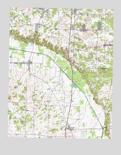
Melber, KY USGS Topographic Map
Click on map above to begin viewing in our Map Viewer.

This topographic map contains these locations and features:
Feature Name Type Latitude Longitude GNIS ID View Map
Allcock CemeteryCemeteryN36.9234°W88.7400°485840View Map
Armistead CemeteryCemeteryN36.8902°W88.7434°486034View Map
BoazPopulated PlaceN36.8856°W88.6345°487591View Map
Carney CreekStreamN36.8928°W88.6409°488951View Map
Diggs ChapelChurchN36.9037°W88.7284°490893View Map
Diggs Chapel - Kansas CemeteryCemeteryN36.9040°W88.7288°2775760View Map
Dunaway CemeteryCemeteryN36.9623°W88.6519°491280View Map
FolsomdalePopulated PlaceN36.8837°W88.6745°492294View Map
Harper CemeteryCemeteryN36.9759°W88.6439°493782View Map
Haynes CemeteryCemeteryN36.9703°W88.7309°493918View Map
Heard CemeteryCemeteryN36.9123°W88.7475°493977View Map
Houser CemeteryCemeteryN36.9761°W88.6441°494643View Map
Houser Grove ChurchChurchN36.9534°W88.6439°494644View Map
Houser Grove Church of Christ CemeteryCemeteryN36.9531°W88.6433°2775759View Map
Hunt CemeteryCemeteryN36.9817°W88.7123°494773View Map
Johnson CemeteryCemeteryN36.8995°W88.6286°495372View Map
Johnson CemeteryCemeteryN36.9622°W88.6626°495374View Map
Johnson CemeteryCemeteryN36.9950°W88.7142°495375View Map
Jones CemeteryCemeteryN36.9938°W88.6442°495470View Map
KansasPopulated PlaceN36.9017°W88.7284°508367View Map
KauffmanPopulated PlaceN36.9723°W88.6990°2743779View Map
Liberty CemeteryCemeteryN36.8917°W88.6839°496354View Map
Liberty ChurchChurchN36.8945°W88.6826°496366View Map
McNeil CemeteryCemeteryN36.9138°W88.6454°497937View Map
MelberPopulated PlaceN36.9464°W88.7253°498042View Map
Melber Fire StationBuildingN36.9448°W88.7259°2636308View Map
Morris CreekStreamN36.9259°W88.6681°498619View Map
New Hope ChurchChurchN36.9870°W88.7464°499348View Map
Oak GrovePopulated PlaceN36.9889°W88.6884°2743788View Map
Purchase CemeteryCemeteryN36.9640°W88.6901°501462View Map
Russell CemeteryCemeteryN36.8903°W88.7342°502510View Map
Saint John CemeteryCemeteryN36.9655°W88.6727°2775758View Map
Saint JohnsPopulated PlaceN36.9664°W88.6720°508998View Map
Salem ChurchChurchN36.8917°W88.6264°502781View Map
Straub CemeteryCemeteryN36.9436°W88.6540°504575View Map
Thompson CemeteryCemeteryN36.9934°W88.7331°505192View Map
Tittsworth CemeteryCemeteryN36.9914°W88.7270°505310View Map
Wice ChurchChurchN36.9462°W88.6664°506706View Map
WKPD-TV (Paducah)TowerN36.9617°W88.6895°518066View Map
Woodlawn Memorial Gardens CemeteryCemeteryN36.9587°W88.6745°507108View Map
WurthPopulated PlaceN36.9647°W88.7225°2743798View Map
YoppPopulated PlaceN36.9944°W88.6636°2743799View Map

Note: Coordinates in the location and feature list above are referenced to NAD83 datum.


Copyright (C) 2008-2025 Ryan Niemi / Sunset Dynamics ... All Rights Reserved