TopoQuest Logo
Do you find TopoQuest useful?
Help keep TopoQuest running and adding new maps/features by donating!
Bitcoin:  19c7KJd3qBynnjoSw5npx9KScwjBe4ifkT
Litecoin:  LXs6TkuXGGXo1vDsWCkWVdjQX94eUKd6ui
Home View Maps Find Maps Find Places Resources & Links


Paducah East, Kentucky Topographic Map

USGS Map Title: Paducah East, KY
USGS Map MRC: 37088A5
DRG (GeoTIFF) Download: o37088a5.tif


Neighboring USGS Topographic Map Quads:


  Metropolis, IL  
37088B6
 

  Paducah NE, IL  
37088B5
 

  Smithland, KY  
37088B4
 

  Paducah West, KY  
37088A6
 

  Paducah East, KY  
37088A5
 

  Little Cypress, KY  
37088A4
 

  Melber, KY  
36088H6
 

  Symsonia, KY  
36088H5
 

  Elva, KY  
36088H4


Map MRC Location:

N38°
W89°
N38°
W88°
H8 H7 H6 H5 H4 H3 H2 H1
G8 G7 G6 G5 G4 G3 G2 G1
F8 F7 F6 F5 F4 F3 F2 F1
E8 E7 E6 E5 E4 E3 E2 E1
D8 D7 D6 D5 D4 D3 D2 D1
C8 C7 C6 C5 C4 C3 C2 C1
B8 B7 B6 B5 B4 B3 B2 B1
A8 A7 A6 A5 A4 A3 A2 A1
N37°
W89°
N37°
W88°

Paducah East, KY USGS 1:24K Topographic Map Preview:
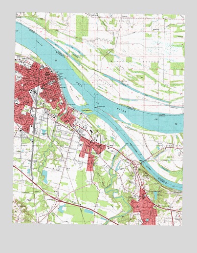
Paducah East, KY USGS Topographic Map
Click on map above to begin viewing in our Map Viewer.

This topographic map contains these locations and features:
Feature Name Type Latitude Longitude GNIS ID View Map
Allard CemeteryCemeteryN37.1212°W88.6048°403415View Map
Allard LakeLakeN37.1027°W88.5899°403416View Map
Barkley ParkParkN37.0928°W88.6028°486355View Map
Bee BranchStreamN37.0064°W88.5950°486657View Map
Black BottomBendN37.0967°W88.5331°404480View Map
Black Bottom School (historical)SchoolN37.0878°W88.5150°1821503View Map
Black PondSwampN37.0396°W88.5104°487382View Map
Blackburn ParkParkN37.0726°W88.5981°487406View Map
Brushy LakeLakeN37.1002°W88.5801°405061View Map
Calvary ChurchChurchN37.0634°W88.5967°488636View Map
Champion CreekStreamN37.0195°W88.6028°489324View Map
Chestnut LakeLakeN37.0332°W88.5128°489452View Map
Clark Memorial BridgeBridgeN37.0381°W88.5287°489544View Map
Clarks RiverStreamN37.0478°W88.5423°489552View Map
Crenshaw CreekStreamN37.1084°W88.5523°424795View Map
Cuba TowheadIslandN37.0664°W88.5717°490454View Map
Devils WashboardAreaN37.1015°W88.5556°407160View Map
Dunbar SchoolSchoolN37.0609°W88.5742°491289View Map
Emma Morgan SchoolSchoolN37.0623°W88.6189°491765View Map
EppersonPopulated PlaceN37.0259°W88.5345°491800View Map
FarleyPopulated PlaceN37.0463°W88.5686°2743771View Map
Farley Census Designated PlaceCensusN37.0405°W88.5735°2629614View Map
Farley Fire StationBuildingN37.0357°W88.5701°2636334View Map
Farley SchoolSchoolN37.0462°W88.5689°491985View Map
Franklin SchoolSchoolN37.0717°W88.5909°492457View Map
Garrison CreekStreamN37.0242°W88.5142°492730View Map
Gray RidgeRidgeN37.0906°W88.5392°409350View Map
Hamilton ChapelChurchN37.0370°W88.6103°493620View Map
Hanifan SchoolSchoolN37.0653°W88.6034°493687View Map
Hendron Fire StationBuildingN37.0019°W88.5290°2637180View Map
Henry Clay SchoolSchoolN37.0714°W88.6145°494059View Map
Herzog CemeteryCemeteryN37.0103°W88.6196°494092View Map
Horse BranchStreamN37.0214°W88.5570°494567View Map
HovekampPopulated PlaceN37.0215°W88.5915°2743777View Map
Howard CemeteryCemeteryN37.1114°W88.5014°410603View Map
Island CreekStreamN37.0717°W88.5853°495045View Map
Jackson Election PrecinctCivilN37.1249°W88.5355°1928519View Map
Jetton Junior High SchoolSchoolN37.0798°W88.6037°495257View Map
Keckolie CemeteryCemeteryN37.1156°W88.5231°411336View Map
Kennedy ParkParkN37.0567°W88.5787°495651View Map
Kinneman LakeLakeN37.0809°W88.5378°411528View Map
Kolb ParkParkN37.0678°W88.5889°495870View Map
Lake GenevieveReservoirN37.0180°W88.5196°492772View Map
Lincoln High SchoolSchoolN37.0776°W88.5989°496551View Map
Little Park School (historical)SchoolN37.1212°W88.5184°1821533View Map
Little Rock ChurchChurchN37.1226°W88.5150°412402View Map
LittlevillePopulated PlaceN37.0612°W88.6034°496907View Map
Livingston PointCapeN37.0692°W88.5637°517321View Map
Longfellow SchoolSchoolN37.0776°W88.6048°497149View Map
Loon LakeLakeN37.1035°W88.5810°412627View Map
McCracken County JailBuildingN37.0817°W88.5991°2767777View Map
McCracken County Sheriff's DepartmentBuildingN37.0826°W88.5993°2767778View Map
McKinley SchoolSchoolN37.0612°W88.5842°497904View Map
Mud CreekStreamN37.1203°W88.6050°414167View Map
North YardLocaleN37.0612°W88.6095°499594View Map
Northside SchoolSchoolN37.0914°W88.6162°499608View Map
Norton BluffCliffN37.0256°W88.5167°499610View Map
Oak Grove CemeteryCemeteryN37.0870°W88.6200°499659View Map
OakdalePopulated PlaceN37.0359°W88.5670°499727View Map
Owens Ferry (historical)CrossingN37.0792°W88.5723°1821554View Map
Owens IslandIslandN37.0767°W88.5812°500076View Map
PaducahPopulated PlaceN37.0834°W88.6000°500106View Map
Paducah and Illinois Fishing CampLocaleN37.0889°W88.5575°425297View Map
Paducah City Police DepartmentBuildingN37.0807°W88.6125°2767784View Map
Paducah Fire Department Station 1BuildingN37.0853°W88.5960°2636404View Map
Paducah Fire Department Station 2BuildingN37.0594°W88.5706°2636814View Map
Paducah Fire Department Station 5BuildingN37.0784°W88.6178°2636607View Map
Paducah Tilghman High SchoolSchoolN37.0728°W88.6237°500107View Map
Paducah TowheadIslandN37.1073°W88.6064°500108View Map
Pearcy CampLocaleN37.0853°W88.5475°415489View Map
Priester LakeLakeN37.0330°W88.5478°501343View Map
Redbird RidgeRidgeN37.0784°W88.5417°416469View Map
ReidlandPopulated PlaceN37.0176°W88.5314°501719View Map
Reidland Census Designated PlaceCensusN37.0085°W88.5261°2403469View Map
Reidland Fire StationBuildingN37.0169°W88.5300°2636758View Map
Riverside HospitalHospitalN37.0923°W88.6009°501994View Map
RiverviewPopulated PlaceN37.0295°W88.5345°501996View Map
Robert E Lee SchoolSchoolN37.0806°W88.5945°502053View Map
Rocky Ford ChurchChurchN37.0326°W88.6109°502242View Map
Rosebower CemeteryCemeteryN37.0033°W88.5010°2775755View Map
Rosebowler ChurchChurchN37.0039°W88.5006°502345View Map
Saint Marys AcademySchoolN37.0884°W88.6000°502688View Map
Schneidman Road ChurchChurchN37.0423°W88.6195°503045View Map
Shady GrovePopulated PlaceN37.1239°W88.5659°418256View Map
Smith Avenue ChurchChurchN37.0548°W88.5931°503723View Map
South YardLocaleN37.0339°W88.6117°503987View Map
Stiles CrossingPopulated PlaceN37.0187°W88.5028°509131View Map
Tennessee RiverStreamN37.0673°W88.5648°517033View Map
TylerPopulated PlaceN37.0601°W88.5828°505739View Map
Union StationLocaleN37.0673°W88.6012°505821View Map
Union Station School (historical)SchoolN37.0392°W88.6053°505822View Map
UnionvillePopulated PlaceN37.1223°W88.5467°420146View Map
WDDJ-FM (Paducah)TowerN37.0987°W88.6220°518002View Map
WDXR-AM (Paducah)TowerN37.0987°W88.6220°517882View Map
Whittier SchoolSchoolN37.0909°W88.6209°506700View Map
WKYQ-FM (Paducah)TowerN37.0148°W88.6128°518003View Map
WKYX-AM (Paducah)TowerN37.0148°W88.6128°517879View Map
WoodlawnPopulated PlaceN37.0420°W88.5689°507103View Map
Woodlawn-Oakdale Census Designated PlaceCensusN37.0403°W88.5735°2403040View Map
WPAD-AM (Paducah)TowerN37.0523°W88.6009°517881View Map

Note: Coordinates in the location and feature list above are referenced to NAD83 datum.


Copyright (C) 2008-2025 Ryan Niemi / Sunset Dynamics ... All Rights Reserved