TopoQuest Logo
Do you find TopoQuest useful?
Help keep TopoQuest running and adding new maps/features by donating!
Bitcoin:  19c7KJd3qBynnjoSw5npx9KScwjBe4ifkT
Litecoin:  LXs6TkuXGGXo1vDsWCkWVdjQX94eUKd6ui
Home View Maps Find Maps Find Places Resources & Links


Menahga, Minnesota Topographic Map

USGS Map Title: Menahga, MN
USGS Map MRC: 46095G1
DRG (GeoTIFF) Download: o46095g1.tif


Neighboring USGS Topographic Map Quads:


  Park Rapids NW, MN  
46095H2
 

  Park Rapids, MN  
46095H1
 

  Dorset, MN  
46094H8
 

  Park Rapids SW, MN  
46095G2
 

  Menahga, MN  
46095G1
 

  Huntersville, MN  
46094G8
 

  Sebeka NW, MN  
46095F2
 

  Sebeka, MN  
46095F1
 

  Nimrod, MN  
46094F8


Map MRC Location:

N47°
W96°
N47°
W95°
H8 H7 H6 H5 H4 H3 H2 H1
G8 G7 G6 G5 G4 G3 G2 G1
F8 F7 F6 F5 F4 F3 F2 F1
E8 E7 E6 E5 E4 E3 E2 E1
D8 D7 D6 D5 D4 D3 D2 D1
C8 C7 C6 C5 C4 C3 C2 C1
B8 B7 B6 B5 B4 B3 B2 B1
A8 A7 A6 A5 A4 A3 A2 A1
N46°
W96°
N46°
W95°

Menahga, MN USGS 1:24K Topographic Map Preview:
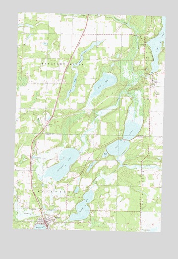
Menahga, MN USGS Topographic Map
Click on map above to begin viewing in our Map Viewer.

This topographic map contains these locations and features:
Feature Name Type Latitude Longitude GNIS ID View Map
Ames Post Office (historical)Post OfficeN46.8528°W95.0653°2093921View Map
Bethany Lutheran ChurchChurchN46.8639°W95.0750°2094635View Map
Bill LakeLakeN46.7941°W95.0487°640152View Map
Blueberry LakeLakeN46.7871°W95.0848°640302View Map
Blueberry RiverStreamN46.7800°W95.0928°640304View Map
Fair Havens Golf CourseLocaleN46.8486°W95.0514°2094634View Map
Falk Private AirportAirportN46.8612°W95.0559°660342View Map
Fishhook RiverStreamN46.8302°W95.0320°643710View Map
Hinds LakeLakeN46.8349°W95.0513°645029View Map
HortonPopulated PlaceN46.8111°W95.0972°654759View Map
HubbardPopulated PlaceN46.8366°W95.0103°645265View Map
Hubbard Post Office (historical)Post OfficeN46.8367°W95.0100°2093899View Map
Latona Post Office (historical)Post OfficeN46.8356°W95.0872°2093875View Map
Long LakeReservoirN46.8416°W95.0120°1776219View Map
Long Lake DamDamN46.8416°W95.0120°1776218View Map
Lord LakeLakeN46.8345°W95.0766°647183View Map
MenahgaPopulated PlaceN46.7538°W95.0981°647760View Map
Menahga Apostolic Lutheran ChurchChurchN46.8361°W95.0875°2094636View Map
Menahga Fire DepartmentBuildingN46.7567°W95.0976°2666206View Map
Menahga Police DepartmentBuildingN46.7567°W95.0976°2758584View Map
Moran LakeLakeN46.8538°W95.0669°648102View Map
Pine Haven ChurchChurchN46.8577°W95.0172°649460View Map
Stocking CreekStreamN46.7875°W95.0361°652649View Map
Stocking LakeLakeN46.7630°W95.0664°652650View Map
Straight RiverStreamN46.8688°W95.0320°652709View Map
Township of BlueberryCivilN46.7634°W95.1007°663623View Map
Township of Straight RiverCivilN46.8484°W95.1002°665725View Map
Twin LakesLakeN46.7991°W95.0332°653448View Map

Note: Coordinates in the location and feature list above are referenced to NAD83 datum.


Copyright (C) 2008-2025 Ryan Niemi / Sunset Dynamics ... All Rights Reserved