TopoQuest Logo
Do you find TopoQuest useful?
Help keep TopoQuest running and adding new maps/features by donating!
Bitcoin:  19c7KJd3qBynnjoSw5npx9KScwjBe4ifkT
Litecoin:  LXs6TkuXGGXo1vDsWCkWVdjQX94eUKd6ui
Home View Maps Find Maps Find Places Resources & Links


Park Rapids, Minnesota Topographic Map

USGS Map Title: Park Rapids, MN
USGS Map MRC: 46095H1
DRG (GeoTIFF) Download: o46095h1.tif


Neighboring USGS Topographic Map Quads:


  Park Rapids NW, MN  
46095H2
 

  Park Rapids, MN  
46095H1
 

  Dorset, MN  
46094H8
 

  Park Rapids SW, MN  
46095G2
 

  Menahga, MN  
46095G1
 

  Huntersville, MN  
46094G8


Map MRC Location:

N47°
W96°
N47°
W95°
H8 H7 H6 H5 H4 H3 H2 H1
G8 G7 G6 G5 G4 G3 G2 G1
F8 F7 F6 F5 F4 F3 F2 F1
E8 E7 E6 E5 E4 E3 E2 E1
D8 D7 D6 D5 D4 D3 D2 D1
C8 C7 C6 C5 C4 C3 C2 C1
B8 B7 B6 B5 B4 B3 B2 B1
A8 A7 A6 A5 A4 A3 A2 A1
N46°
W96°
N46°
W95°

Park Rapids, MN USGS 1:24K Topographic Map Preview:
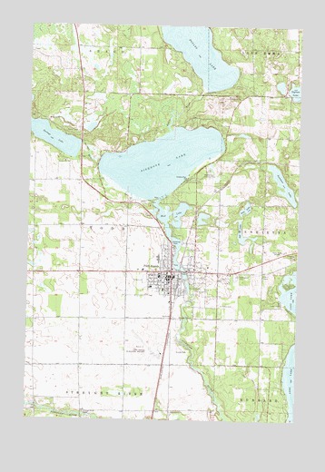
Park Rapids, MN USGS Topographic Map
Click on map above to begin viewing in our Map Viewer.

This topographic map contains these locations and features:
Feature Name Type Latitude Longitude GNIS ID View Map
All Veterans MemorialParkN46.9097°W95.0575°2093944View Map
Assemblies of God ChurchChurchN46.9214°W95.0786°2093885View Map
Big Pines Tent and RV ParkLocaleN46.9164°W95.0486°2093941View Map
Calvary Lutheran ChurchChurchN46.9214°W95.0578°2093877View Map
Church of ChristChannelN46.9303°W95.0600°2093881View Map
Church of the NazareneChurchN46.9203°W95.0792°2093884View Map
City of Park RapidsCivilN46.9171°W95.0598°2396147View Map
Dakota Clinic - Park RapidsHospitalN46.9164°W95.0617°2093909View Map
Deane ParkParkN46.9439°W95.0689°2093952View Map
Faith ChurchChurchN46.9077°W95.0589°643543View Map
First Baptist Christian SchoolSchoolN46.9147°W95.0806°2093902View Map
First Baptist ChurchChurchN46.9147°W95.0806°2093886View Map
Fish Hook Lake Wayside ParkParkN46.9317°W95.0581°2094631View Map
Fish Hook River DamDamN46.9200°W95.0520°1776301View Map
Fish Hook River ReservoirReservoirN46.9329°W95.0588°1776302View Map
Fishhook LakeLakeN46.9570°W95.0642°643708View Map
Frank White Elementary SchoolSchoolN46.9258°W95.0644°2093905View Map
Green AcresParkN46.9200°W95.0319°2093942View Map
Greenwood CemeteryCemeteryN46.9205°W95.0286°644463View Map
Headwaters Country ClubLocaleN46.9522°W95.0447°659850View Map
Heartland ParkParkN46.9278°W95.0536°2093951View Map
Hubbard County CourthouseBuildingN46.9206°W95.0639°2093947View Map
Hubbard County FairgroundsLocaleN46.9194°W95.0694°2093945View Map
Hubbard County Historical MuseumBuildingN46.9206°W95.0639°2093948View Map
Hubbard County JailBuildingN46.9197°W95.0636°2758668View Map
Hubbard County Sheriff's Office Park RapidsBuildingN46.9197°W95.0636°2093949View Map
Ingram LakeLakeN46.9795°W95.0028°645427View Map
Ivan LakeLakeN46.9425°W95.0243°645544View Map
KDKK-FM (Park Rapids)TowerN46.9283°W95.0064°663101View Map
KPRM-AM (Park Rapids)TowerN46.9283°W95.0064°662963View Map
KPRM-AM (Park Rapids)TowerN46.9050°W95.0181°662964View Map
Minnesota State Fish HatcheryLocaleN46.9167°W95.0486°2093940View Map
Mud LakeLakeN46.9404°W95.0552°648325View Map
New Century SchoolSchoolN46.9292°W95.0678°2093904View Map
New Life Christian FellowshipChurchN46.9242°W95.0478°2093878View Map
North Ambulance Park RapidsBuildingN46.9214°W95.0409°2721321View Map
Northern Pine ChurchChurchN46.9519°W95.0528°648723View Map
Park EstatesPopulated PlaceN46.9403°W95.0153°2093907View Map
Park RapidsPopulated PlaceN46.9222°W95.0586°649151View Map
Park Rapids Fire DepartmentBuildingN46.9141°W95.0578°2093924View Map
Park Rapids High SchoolSchoolN46.9258°W95.0644°2093903View Map
Park Rapids Municipal Airport-Konshok FieldAirportN46.8991°W95.0658°660343View Map
Park Rapids Police DepartmentBuildingN46.9082°W95.0697°2093946View Map
Park Rapids Post OfficePost OfficeN46.9198°W95.0588°2093926View Map
Park Rapids Public LibraryBuildingN46.9217°W95.0600°2093925View Map
Park Rapids Railroad Station (historical)LocaleN46.9194°W95.0550°2093927View Map
Portage LakeReservoirN46.9633°W95.1003°1776215View Map
Portage LakeLakeN46.9657°W95.1202°649669View Map
Portage Lake DamDamN46.9633°W95.1003°1776214View Map
Portage RiverStreamN46.9572°W95.0922°649672View Map
Potato LakeReservoirN46.9783°W95.0470°1776217View Map
Potato Lake DamDamN46.9783°W95.0470°1776216View Map
Potato RiverStreamN46.9666°W95.0600°649690View Map
Riverside United Methodist ChurchChurchN46.9125°W95.0583°2093883View Map
Saint John's Lutheran ChurchChurchN46.9225°W95.0711°2093882View Map
Saint Joseph's Area Health ServicesHospitalN46.9163°W95.0622°2093908View Map
Saint Peter's Catholic ChurchChurchN46.9181°W95.0614°2093880View Map
Saint Peters CemeteryCemeteryN46.9116°W95.0367°651023View Map
Sill LakeLakeN46.9351°W95.0268°652019View Map
Silver Star Festival ParkParkN46.9208°W95.0306°2093943View Map
Skoe ParkParkN46.9253°W95.0514°2093950View Map
Spruce Hill CampgroundsLocaleN46.9153°W95.0083°2093936View Map
Straight River CemeteryCemeteryN46.8775°W95.0983°652710View Map
Sweitzer LakeLakeN46.9502°W95.0075°652945View Map
Township of ToddCivilN46.9389°W95.1074°665793View Map
Trinity Episcopal ChurchChurchN46.9200°W95.0625°2093879View Map
Up North MallLocaleN46.9194°W95.0589°2093923View Map
Vern's Trailer CourtLocaleN46.9158°W95.0592°2093922View Map

Note: Coordinates in the location and feature list above are referenced to NAD83 datum.


Copyright (C) 2008-2024 Ryan Niemi / Sunset Dynamics ... All Rights Reserved