TopoQuest Logo
Do you find TopoQuest useful?
Help keep TopoQuest running and adding new maps/features by donating!
Bitcoin:  19c7KJd3qBynnjoSw5npx9KScwjBe4ifkT
Litecoin:  LXs6TkuXGGXo1vDsWCkWVdjQX94eUKd6ui
Home View Maps Find Maps Find Places Resources & Links


Mendon, Michigan Topographic Map

USGS Map Title: Mendon, MI
USGS Map MRC: 42085A4
DRG (GeoTIFF) Download: o42085a4.tif


Neighboring USGS Topographic Map Quads:


  Portage, MI  
42085B5
 

  Adams Park, MI  
42085B4
 

  Climax, MI  
42085B3
 

  Vicksburg, MI  
42085A5
 

  Mendon, MI  
42085A4
 

  Leonidas, MI  
42085A3
 

  Three Rivers East, MI  
41085H5
 

  Nottawa, MI  
41085H4
 

  Colon, MI  
41085H3


Map MRC Location:

N43°
W86°
N43°
W85°
H8 H7 H6 H5 H4 H3 H2 H1
G8 G7 G6 G5 G4 G3 G2 G1
F8 F7 F6 F5 F4 F3 F2 F1
E8 E7 E6 E5 E4 E3 E2 E1
D8 D7 D6 D5 D4 D3 D2 D1
C8 C7 C6 C5 C4 C3 C2 C1
B8 B7 B6 B5 B4 B3 B2 B1
A8 A7 A6 A5 A4 A3 A2 A1
N42°
W86°
N42°
W85°

Mendon, MI USGS 1:24K Topographic Map Preview:
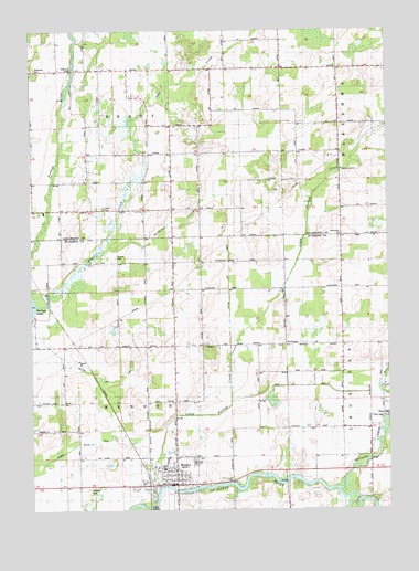
Mendon, MI USGS Topographic Map
Click on map above to begin viewing in our Map Viewer.

This topographic map contains these locations and features:
Feature Name Type Latitude Longitude GNIS ID View Map
Bear CreekStreamN42.0298°W85.3758°1624372View Map
Bear CreekStreamN42.0709°W85.4728°1623094View Map
Beard CemeteryCemeteryN42.0711°W85.3917°2401231View Map
Brady SchoolSchoolN42.0895°W85.4514°621864View Map
Brown SchoolSchoolN42.1223°W85.4319°622091View Map
Butternut CreekStreamN42.0542°W85.4992°1624430View Map
Dinger SchoolSchoolN42.0787°W85.4903°624687View Map
Dutton CemeteryCemeteryN42.0662°W85.4705°1624500View Map
Freedom Baptist ChurchChurchN42.0933°W85.3922°2401139View Map
Garman Foster DrainCanalN42.0097°W85.4986°2112775View Map
Hall SchoolSchoolN42.0420°W85.4692°1624586View Map
Hassic CemeteryCemeteryN42.0787°W85.4750°627925View Map
Holcomb SchoolSchoolN42.1000°W85.3967°628412View Map
Jenkinson CemeteryCemeteryN42.1150°W85.4983°2112759View Map
Jenkinson SchoolSchoolN42.1150°W85.4994°629256View Map
Kings MillLocaleN42.0242°W85.3758°1624645View Map
Life Care Ambulance ServiceBuildingN42.0074°W85.4528°2662041View Map
Little Portage CreekStreamN42.0053°W85.4564°1624685View Map
Maple Grove SchoolSchoolN42.0578°W85.3897°1624703View Map
MendonPopulated PlaceN42.0064°W85.4500°1624728View Map
Mendon CemeteryCemeteryN42.0053°W85.4808°1624729View Map
Mendon Community High SchoolSchoolN42.0122°W85.4431°2401137View Map
Mendon Elementary SchoolSchoolN42.0128°W85.4528°2401138View Map
Mendon Fire RescueBuildingN42.0077°W85.4534°2401131View Map
Mendon Police DepartmentBuildingN42.0071°W85.4521°2401135View Map
Mendon Post OfficePost OfficeN42.0069°W85.4506°2401133View Map
Mendon Station (historical)LocaleN42.0075°W85.4589°2401132View Map
Mendon Township HallBuildingN42.0069°W85.4514°2401134View Map
Mendon Township LibraryBuildingN42.0069°W85.4533°2401136View Map
Mendon United Methodist ChurchChurchN42.0069°W85.4542°2401142View Map
Nottawa CreekStreamN42.0042°W85.3944°1624794View Map
Oak Shores Resort CampgroundLocaleN42.1222°W85.4931°2627841View Map
Olney Bridge ParkParkN42.0125°W85.3811°2417889View Map
Portage Lake DrainCanalN42.0367°W85.4811°2112776View Map
Rawson's King Mill ParkParkN42.0244°W85.3764°2417888View Map
Reserve SchoolSchoolN42.0200°W85.3917°1624856View Map
Saint Edward's Catholic Church CemeteryCemeteryN42.0083°W85.4556°2401230View Map
Saint Edwards Catholic ChurchChurchN42.0081°W85.4547°2401141View Map
Saint Patrick ParishChurchN42.0428°W85.4117°2567085View Map
Sprung CemeteryCemeteryN42.0214°W85.4194°2401229View Map
Township of BradyCivilN42.1144°W85.4708°1625967View Map
Township of MendonCivilN42.0278°W85.4696°1626722View Map
Village of MendonCivilN42.0089°W85.4548°2399314View Map
Wakeshma ChurchChurchN42.0712°W85.3917°1624999View Map
Wakeshma ChurchChurchN42.0717°W85.3917°2112758View Map

Note: Coordinates in the location and feature list above are referenced to NAD83 datum.


Copyright (C) 2008-2025 Ryan Niemi / Sunset Dynamics ... All Rights Reserved