TopoQuest Logo
Do you find TopoQuest useful?
Help keep TopoQuest running and adding new maps/features by donating!
Bitcoin:  19c7KJd3qBynnjoSw5npx9KScwjBe4ifkT
Litecoin:  LXs6TkuXGGXo1vDsWCkWVdjQX94eUKd6ui
Home View Maps Find Maps Find Places Resources & Links


Mendon, Missouri Topographic Map

USGS Map Title: Mendon, MO
USGS Map MRC: 39093E2
DRG (GeoTIFF) Download: o39093e2.tif


Neighboring USGS Topographic Map Quads:


  Fountain Grove, MO  
39093F3
 

  Sumner, MO  
39093F2
 

  Rothville, MO  
39093F1
 

  Hale, MO  
39093E3
 

  Mendon, MO  
39093E2
 

  Indian Grove, MO  
39093E1
 

  Bosworth, MO  
39093D3
 

  Brunswick West, MO  
39093D2
 

  Brunswick East, MO  
39093D1


Map MRC Location:

N40°
W94°
N40°
W93°
H8 H7 H6 H5 H4 H3 H2 H1
G8 G7 G6 G5 G4 G3 G2 G1
F8 F7 F6 F5 F4 F3 F2 F1
E8 E7 E6 E5 E4 E3 E2 E1
D8 D7 D6 D5 D4 D3 D2 D1
C8 C7 C6 C5 C4 C3 C2 C1
B8 B7 B6 B5 B4 B3 B2 B1
A8 A7 A6 A5 A4 A3 A2 A1
N39°
W94°
N39°
W93°

Mendon, MO USGS 1:24K Topographic Map Preview:
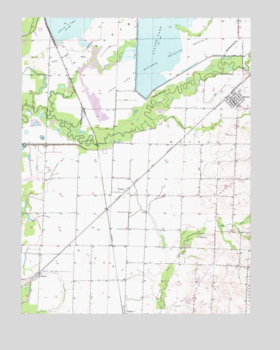
Mendon, MO USGS Topographic Map
Click on map above to begin viewing in our Map Viewer.

This topographic map contains these locations and features:
Feature Name Type Latitude Longitude GNIS ID View Map
City of MendonCivilN39.5906°W93.1339°2395094View Map
Collinswood (historical)LocaleN39.5864°W93.2166°740466View Map
Eagle Lodge AirportAirportN39.5565°W93.2424°758961View Map
Elk CreekStreamN39.5839°W93.2360°717454View Map
Hampton Feed LotLocaleN39.5044°W93.1594°2581915View Map
Hickory BranchStreamN39.5820°W93.1791°719437View Map
Hog RidgeRidgeN39.6072°W93.2294°719682View Map
Hog Ridge School (historical)SchoolN39.6003°W93.2358°734037View Map
Jackson CemeteryCemeteryN39.5328°W93.1524°720209View Map
Levee 2 - South Pool DamDamN39.6134°W93.2135°760689View Map
Levee 3-Silver Lake DamDamN39.5917°W93.1852°760691View Map
Levee 5-Swan Lake DamDamN39.6217°W93.2369°760693View Map
MendonPopulated PlaceN39.5897°W93.1346°735720View Map
Mendon Post OfficePost OfficeN39.5904°W93.1353°2782803View Map
Mendon Public Fire Protection DistrictBuildingN39.5869°W93.1329°2621171View Map
Refuge HeadquartersLocaleN39.6134°W93.2299°736076View Map
Silver LakeReservoirN39.6109°W93.1869°726453View Map
Silver Lake PoolReservoirN39.5917°W93.1852°760692View Map
SnyderPopulated PlaceN39.5164°W93.2402°735858View Map
South LakeReservoirN39.5872°W93.2091°736075View Map
South PoolReservoirN39.6134°W93.2135°760690View Map
Stephenson CemeteryCemeteryN39.5392°W93.2416°727075View Map
Stephenson School (historical)SchoolN39.5428°W93.2421°734038View Map
Swan LakeReservoirN39.6131°W93.2138°727358View Map
Swan Lake National Wildlife RefugeParkN39.6113°W93.1851°727359View Map
Swan Lake PoolReservoirN39.6217°W93.2369°760694View Map
Township of MendonCivilN39.5719°W93.1429°766464View Map
Township of TriplettCivilN39.5075°W93.2113°766469View Map
WhithamPopulated PlaceN39.5511°W93.1980°741358View Map

Note: Coordinates in the location and feature list above are referenced to NAD83 datum.


Copyright (C) 2008-2025 Ryan Niemi / Sunset Dynamics ... All Rights Reserved