TopoQuest Logo
Do you find TopoQuest useful?
Help keep TopoQuest running and adding new maps/features by donating!
Bitcoin:  19c7KJd3qBynnjoSw5npx9KScwjBe4ifkT
Litecoin:  LXs6TkuXGGXo1vDsWCkWVdjQX94eUKd6ui
Home View Maps Find Maps Find Places Resources & Links


Rothville, Missouri Topographic Map

USGS Map Title: Rothville, MO
USGS Map MRC: 39093F1
DRG (GeoTIFF) Download: o39093f1.tif


Neighboring USGS Topographic Map Quads:


  Laclede, MO  
39093G2
 

  Brookfield, MO  
39093G1
 

  Bucklin, MO  
39092G8
 

  Sumner, MO  
39093F2
 

  Rothville, MO  
39093F1
 

  Marceline, MO  
39092F8
 

  Mendon, MO  
39093E2
 

  Indian Grove, MO  
39093E1
 

  Mike, MO  
39092E8


Map MRC Location:

N40°
W94°
N40°
W93°
H8 H7 H6 H5 H4 H3 H2 H1
G8 G7 G6 G5 G4 G3 G2 G1
F8 F7 F6 F5 F4 F3 F2 F1
E8 E7 E6 E5 E4 E3 E2 E1
D8 D7 D6 D5 D4 D3 D2 D1
C8 C7 C6 C5 C4 C3 C2 C1
B8 B7 B6 B5 B4 B3 B2 B1
A8 A7 A6 A5 A4 A3 A2 A1
N39°
W94°
N39°
W93°

Rothville, MO USGS 1:24K Topographic Map Preview:
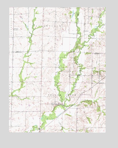
Rothville, MO USGS Topographic Map
Click on map above to begin viewing in our Map Viewer.

This topographic map contains these locations and features:
Feature Name Type Latitude Longitude GNIS ID View Map
East Yellow CreekStreamN39.6514°W93.0538°717355View Map
Farm Service Agency Interest of MissouriParkN39.6854°W93.0365°2765293View Map
Goose LakeLakeN39.7415°W93.0431°718600View Map
Halls BranchStreamN39.6884°W93.0313°719015View Map
Hess School (historical)SchoolN39.7422°W93.0644°733993View Map
Holloway SchoolSchoolN39.6745°W93.0077°719720View Map
Johnson School (historical)SchoolN39.7217°W93.0813°733992View Map
Pershing SchoolSchoolN39.7284°W93.1188°735776View Map
Redding CemeteryCemeteryN39.7000°W93.0416°725170View Map
RothvillePopulated PlaceN39.6534°W93.0641°725590View Map
Rothville CemeteryCemeteryN39.6545°W93.0617°2681419View Map
Rothville Post OfficePost OfficeN39.6534°W93.0612°2782599View Map
Slater BranchStreamN39.6520°W93.0535°726532View Map
South Eagle ChurchChurchN39.7275°W93.1199°726719View Map
Spring BranchStreamN39.7234°W93.0955°726892View Map
Stains CemeteryCemeteryN39.7256°W93.0202°726989View Map
Stains SchoolSchoolN39.7261°W93.0269°726990View Map
Township of Yellow CreekCivilN39.6605°W93.0470°766471View Map
Village of RothvilleCivilN39.6539°W93.0635°2399130View Map
West Yellow CreekStreamN39.6514°W93.0538°728642View Map
White Oak BranchStreamN39.6395°W93.0699°728739View Map
Yellow Creek Fire Protection DistrictBuildingN39.6537°W93.0702°2620256View Map

Note: Coordinates in the location and feature list above are referenced to NAD83 datum.


Copyright (C) 2008-2024 Ryan Niemi / Sunset Dynamics ... All Rights Reserved