TopoQuest Logo
Do you find TopoQuest useful?
Help keep TopoQuest running and adding new maps/features by donating!
Bitcoin:  19c7KJd3qBynnjoSw5npx9KScwjBe4ifkT
Litecoin:  LXs6TkuXGGXo1vDsWCkWVdjQX94eUKd6ui
Home View Maps Find Maps Find Places Resources & Links


Bosworth, Missouri Topographic Map

USGS Map Title: Bosworth, MO
USGS Map MRC: 39093D3
DRG (GeoTIFF) Download: o39093d3.tif


Neighboring USGS Topographic Map Quads:


  Tina, MO  
39093E4
 

  Hale, MO  
39093E3
 

  Mendon, MO  
39093E2
 

  Standish, MO  
39093D4
 

  Bosworth, MO  
39093D3
 

  Brunswick West, MO  
39093D2
 

  Carrollton East, MO  
39093C4
 

  Miami Station, MO  
39093C3
 

  Miami, MO  
39093C2


Map MRC Location:

N40°
W94°
N40°
W93°
H8 H7 H6 H5 H4 H3 H2 H1
G8 G7 G6 G5 G4 G3 G2 G1
F8 F7 F6 F5 F4 F3 F2 F1
E8 E7 E6 E5 E4 E3 E2 E1
D8 D7 D6 D5 D4 D3 D2 D1
C8 C7 C6 C5 C4 C3 C2 C1
B8 B7 B6 B5 B4 B3 B2 B1
A8 A7 A6 A5 A4 A3 A2 A1
N39°
W94°
N39°
W93°

Bosworth, MO USGS 1:24K Topographic Map Preview:
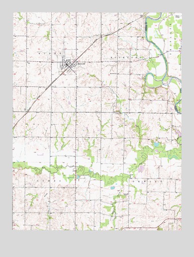
Bosworth, MO USGS Topographic Map
Click on map above to begin viewing in our Map Viewer.

This topographic map contains these locations and features:
Feature Name Type Latitude Longitude GNIS ID View Map
BosworthPopulated PlaceN39.4697°W93.3347°730061View Map
Bosworth Elementary SchoolSchoolN39.4683°W93.3322°2545501View Map
Bosworth High SchoolSchoolN39.4685°W93.3320°2545502View Map
Bosworth Post OfficePost OfficeN39.4699°W93.3355°2782855View Map
Bosworth Volunteer Fire DepartmentBuildingN39.4678°W93.3329°2621594View Map
City of BosworthCivilN39.4699°W93.3356°2394224View Map
Craig School (historical)SchoolN39.4417°W93.2613°746964View Map
Crispin School (historical)SchoolN39.3906°W93.2780°746966View Map
Darr BranchStreamN39.4081°W93.3441°716675View Map
Grace LakeReservoirN39.4306°W93.2520°761109View Map
Grace Lake DamDamN39.4300°W93.2502°761108View Map
Guillett School (historical)SchoolN39.3928°W93.3224°746962View Map
Lakeview DamDamN39.4084°W93.2819°761315View Map
Lick BranchStreamN39.3861°W93.2997°721017View Map
Lucas School (historical)SchoolN39.3997°W93.3588°746961View Map
MilfordPopulated PlaceN39.4070°W93.3691°755664View Map
Parker BranchStreamN39.4220°W93.2785°724028View Map
Peavine BranchStreamN39.4056°W93.2935°724154View Map
Pleasant Park CemeteryCemeteryN39.3950°W93.2916°724570View Map
Rockford ChurchChurchN39.4650°W93.2983°725478View Map
Rockford School (historical)SchoolN39.4647°W93.2933°746963View Map
Sand BranchStreamN39.4286°W93.2510°725999View Map
Snow BranchStreamN39.4109°W93.3413°726671View Map
Township of CombsCivilN39.3994°W93.3652°766407View Map
Township of RidgeCivilN39.4860°W93.3655°766418View Map
Township of RockfordCivilN39.4774°W93.2797°766419View Map
Union CemeteryCemeteryN39.4575°W93.3471°727966View Map
West Fairview School (historical)SchoolN39.4289°W93.3552°746960View Map
Wharton CemeteryCemeteryN39.4428°W93.2974°728677View Map
White Swan School (historical)SchoolN39.4275°W93.3108°746965View Map

Note: Coordinates in the location and feature list above are referenced to NAD83 datum.


Copyright (C) 2008-2025 Ryan Niemi / Sunset Dynamics ... All Rights Reserved