TopoQuest Logo
Do you find TopoQuest useful?
Help keep TopoQuest running and adding new maps/features by donating!
Bitcoin:  19c7KJd3qBynnjoSw5npx9KScwjBe4ifkT
Litecoin:  LXs6TkuXGGXo1vDsWCkWVdjQX94eUKd6ui
Home View Maps Find Maps Find Places Resources & Links


Merna, Illinois Topographic Map

USGS Map Title: Merna, IL
USGS Map MRC: 40088E7
DRG (GeoTIFF) Download: o40088e7.tif


Neighboring USGS Topographic Map Quads:


  Gridley, IL  
40088F8
 

  Lexington, IL  
40088F7
 

  Chenoa, IL  
40088F6
 

  Normal East, IL  
40088E8
 

  Merna, IL  
40088E7
 

  Cooksville, IL  
40088E6
 

  Bloomington East, IL  
40088D8
 

  Holder, IL  
40088D7
 

  Arrowsmith, IL  
40088D6


Map MRC Location:

N41°
W89°
N41°
W88°
H8 H7 H6 H5 H4 H3 H2 H1
G8 G7 G6 G5 G4 G3 G2 G1
F8 F7 F6 F5 F4 F3 F2 F1
E8 E7 E6 E5 E4 E3 E2 E1
D8 D7 D6 D5 D4 D3 D2 D1
C8 C7 C6 C5 C4 C3 C2 C1
B8 B7 B6 B5 B4 B3 B2 B1
A8 A7 A6 A5 A4 A3 A2 A1
N40°
W89°
N40°
W88°

Merna, IL USGS 1:24K Topographic Map Preview:
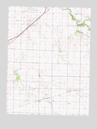
Merna, IL USGS Topographic Map
Click on map above to begin viewing in our Map Viewer.

This topographic map contains these locations and features:
Feature Name Type Latitude Longitude GNIS ID View Map
Ballard School (historical)SchoolN40.5014°W88.8637°403862View Map
Blue MoundSummitN40.5134°W88.7790°404598View Map
Chandler School (historical)SchoolN40.5467°W88.8648°405948View Map
Crooked CreekStreamN40.5806°W88.7976°406803View Map
Crooked CreekStreamN40.5959°W88.7659°406804View Map
FletcherPopulated PlaceN40.5270°W88.7837°422703View Map
Frog Alley School (historical)SchoolN40.5900°W88.8559°408772View Map
Horney School (historical)SchoolN40.5886°W88.7756°410548View Map
Indian Field CemeteryCemeteryN40.6175°W88.7737°1747591View Map
Lincoln School (historical)SchoolN40.5020°W88.7831°412165View Map
Little Crooked CreekStreamN40.6050°W88.7681°412324View Map
MernaPopulated PlaceN40.5167°W88.8259°413436View Map
Merna CemeteryCemeteryN40.5163°W88.8060°1747608View Map
Merna School (historical)SchoolN40.5014°W88.8259°413437View Map
P J Killian AirportAirportN40.6025°W88.8340°2679059View Map
Patton CreekStreamN40.6059°W88.7637°415451View Map
Phoenix School (historical)SchoolN40.5520°W88.8256°415622View Map
Pleasant Hill CemeteryCemeteryN40.6133°W88.7520°1952809View Map
Popejoy School (historical)SchoolN40.6042°W88.8073°416025View Map
Schlosser Airport (historical)AirportN40.5189°W88.8209°427534View Map
Smith Grove CemeteryCemeteryN40.5495°W88.8637°1747632View Map
Snow RLA Airport (historical)AirportN40.5414°W88.8215°427872View Map
Township of Money CreekCivilN40.6213°W88.8668°429383View Map
Township of TowandaCivilN40.5336°W88.8628°429839View Map
Union School (historical)SchoolN40.5600°W88.7840°420121View Map

Note: Coordinates in the location and feature list above are referenced to NAD83 datum.


Copyright (C) 2008-2025 Ryan Niemi / Sunset Dynamics ... All Rights Reserved