TopoQuest Logo
Do you find TopoQuest useful?
Help keep TopoQuest running and adding new maps/features by donating!
Bitcoin:  19c7KJd3qBynnjoSw5npx9KScwjBe4ifkT
Litecoin:  LXs6TkuXGGXo1vDsWCkWVdjQX94eUKd6ui
Home View Maps Find Maps Find Places Resources & Links


Gridley, Illinois Topographic Map

USGS Map Title: Gridley, IL
USGS Map MRC: 40088F8
DRG (GeoTIFF) Download: o40088f8.tif


Neighboring USGS Topographic Map Quads:


  Benson, IL  
40089G1
 

  Flanagan SW, IL  
40088G8
 

  Flanagan South, IL  
40088G7
 

  El Paso, IL  
40089F1
 

  Gridley, IL  
40088F8
 

  Lexington, IL  
40088F7
 

  Normal West, IL  
40089E1
 

  Normal East, IL  
40088E8
 

  Merna, IL  
40088E7


Map MRC Location:

N41°
W89°
N41°
W88°
H8 H7 H6 H5 H4 H3 H2 H1
G8 G7 G6 G5 G4 G3 G2 G1
F8 F7 F6 F5 F4 F3 F2 F1
E8 E7 E6 E5 E4 E3 E2 E1
D8 D7 D6 D5 D4 D3 D2 D1
C8 C7 C6 C5 C4 C3 C2 C1
B8 B7 B6 B5 B4 B3 B2 B1
A8 A7 A6 A5 A4 A3 A2 A1
N40°
W89°
N40°
W88°

Gridley, IL USGS 1:24K Topographic Map Preview:
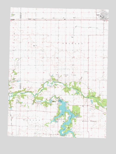
Gridley, IL USGS Topographic Map
Click on map above to begin viewing in our Map Viewer.

This topographic map contains these locations and features:
Feature Name Type Latitude Longitude GNIS ID View Map
Big SloughStreamN40.6378°W88.9456°1983933View Map
Camp HeffernanLocaleN40.6370°W88.9548°1747543View Map
Camp PeairsLocaleN40.6411°W88.9251°1747544View Map
East Bay CampLocaleN40.6448°W88.9131°1747561View Map
El Paso CemeteryCemeteryN40.7435°W88.9976°1801986View Map
El Paso Golf ClubLocaleN40.6806°W88.9929°1824266View Map
EnrightPopulated PlaceN40.7398°W88.9670°422674View Map
Fishburn School (historical)SchoolN40.7228°W88.9662°408395View Map
Four Corners School (historical)SchoolN40.7095°W88.9201°408587View Map
Freed School (historical)SchoolN40.7173°W88.8817°408716View Map
Grandview School (historical)SchoolN40.7389°W88.9298°409279View Map
Gregory ChurchChurchN40.6492°W88.9159°1747578View Map
Gregory School (historical)SchoolN40.6764°W88.9012°409483View Map
GridleyPopulated PlaceN40.7434°W88.8815°409494View Map
Gridley Elementary SchoolSchoolN40.7436°W88.8856°1822481View Map
Gridley Emergency Medical ServicesBuildingN40.7421°W88.8807°2673960View Map
Gridley Fire Protection DistrictBuildingN40.7425°W88.8817°2681788View Map
Gridley High SchoolSchoolN40.7428°W88.8853°1747579View Map
Gridley Junior High SchoolSchoolN40.7439°W88.8853°1822482View Map
Gridley Police DepartmentBuildingN40.7421°W88.8801°2757072View Map
Gridley Post OfficePost OfficeN40.7432°W88.8810°2788404View Map
Hickory CreekStreamN40.6523°W88.9287°410144View Map
Hinthorn CemeteryCemeteryN40.6276°W88.9267°1952869View Map
Hinthorn ChapelChurchN40.6270°W88.9265°420058View Map
Hudson Community Fire Protection District LakeBuildingN40.6484°W88.9364°2682270View Map
Lake BloomingtonReservoirN40.6281°W88.9283°1747538View Map
Loving BranchStreamN40.6731°W88.9187°412700View Map
Messer CemeteryCemeteryN40.6598°W88.9672°1747609View Map
Money CreekStreamN40.6645°W88.9676°413722View Map
Pleasant Grove School (historical)SchoolN40.6417°W88.9367°415811View Map
Pleasant View School (historical)SchoolN40.6803°W88.9473°415935View Map
Prairie College School (historical)SchoolN40.7023°W88.9576°416114View Map
Township of GridleyCivilN40.7101°W88.8999°429084View Map
Union School (historical)SchoolN40.6350°W88.9648°420122View Map
Village of GridleyCivilN40.7439°W88.8806°2398210View Map
Wilcox School (historical)SchoolN40.6534°W88.8901°421140View Map
Wilcox-Coon CemeteryCemeteryN40.6561°W88.9040°1747649View Map

Note: Coordinates in the location and feature list above are referenced to NAD83 datum.


Copyright (C) 2008-2025 Ryan Niemi / Sunset Dynamics ... All Rights Reserved