TopoQuest Logo
Do you find TopoQuest useful?
Help keep TopoQuest running and adding new maps/features by donating!
Bitcoin:  19c7KJd3qBynnjoSw5npx9KScwjBe4ifkT
Litecoin:  LXs6TkuXGGXo1vDsWCkWVdjQX94eUKd6ui
Home View Maps Find Maps Find Places Resources & Links


Messers Pond, South Carolina Topographic Map

USGS Map Title: Messers Pond, SC
USGS Map MRC: 34080A7
DRG (GeoTIFF) Download: o34080a7.tif


Neighboring USGS Topographic Map Quads:


  Blythewood, SC  
34080B8
 

  Elgin, SC  
34080B7
 

  Lugoff, SC  
34080B6
 

  Fort Jackson North, SC  
34080A8
 

  Messers Pond, SC  
34080A7
 

  Leesburg, SC  
34080A6
 

  Fort Jackson South, SC  
33080H8
 

  Congaree, SC  
33080H7
 

  Eastover, SC  
33080H6


Map MRC Location:

N35°
W81°
N35°
W80°
H8 H7 H6 H5 H4 H3 H2 H1
G8 G7 G6 G5 G4 G3 G2 G1
F8 F7 F6 F5 F4 F3 F2 F1
E8 E7 E6 E5 E4 E3 E2 E1
D8 D7 D6 D5 D4 D3 D2 D1
C8 C7 C6 C5 C4 C3 C2 C1
B8 B7 B6 B5 B4 B3 B2 B1
A8 A7 A6 A5 A4 A3 A2 A1
N34°
W81°
N34°
W80°

Messers Pond, SC USGS 1:24K Topographic Map Preview:
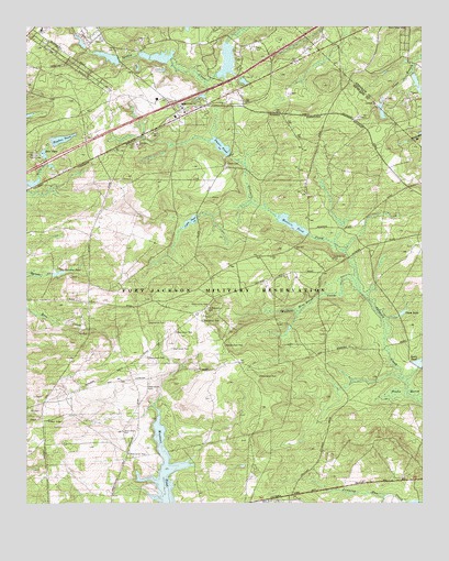
Messers Pond, SC USGS Topographic Map
Click on map above to begin viewing in our Map Viewer.

This topographic map contains these locations and features:
Feature Name Type Latitude Longitude GNIS ID View Map
Bardell GraveyardCemeteryN34.0551°W80.7626°1248919View Map
Bells CampLocaleN34.0913°W80.8715°1220486View Map
Bells PondReservoirN34.0919°W80.8693°1220488View Map
Berkeley Endoscopy CenterHospitalN34.0949°W80.8583°2640112View Map
Buffalo Church (historical)ChurchN34.0371°W80.8151°1248973View Map
Buffalo CreekStreamN34.0554°W80.7695°1221087View Map
Camp Barstow (historical)LocaleN34.0593°W80.8654°1248982View Map
Carlisle School (historical)SchoolN34.0532°W80.8706°1248986View Map
Chimney RidgePopulated PlaceN34.0993°W80.8518°1249003View Map
Cobbs PondReservoirN34.0740°W80.8232°1221656View Map
Cobbs Pond Dam D-1675DamN34.0749°W80.8209°1237843View Map
Columbia - Richland Fire Department Northeast ColumbiaBuildingN34.1116°W80.8397°2578865View Map
Coopers LakeReservoirN34.1173°W80.8318°1237658View Map
Coopers Lake D-0574 DamDamN34.1168°W80.8298°1237657View Map
Dupre PondReservoirN34.0939°W80.8134°1222160View Map
Dupre Pond Dam D-1674DamN34.0915°W80.8104°1237847View Map
F Coopers PondReservoirN34.1162°W80.8115°1237664View Map
Fort JacksonMilitaryN34.0476°W80.8334°2512203View Map
Fort Jackson DivisionCensusN34.0400°W80.8269°2584537View Map
Fort Jackson National CemeteryCemeteryN34.0907°W80.8499°2701924View Map
Gills Creek School (historical)SchoolN34.0632°W80.8512°1249114View Map
Gray Shadow FarmLocaleN34.0919°W80.7617°2652400View Map
Hughes PondReservoirN34.0956°W80.8637°1223386View Map
Hughes Pond D-0573 DamDamN34.0952°W80.8665°1239115View Map
Interchange 80CrossingN34.0949°W80.8562°1228158View Map
Interchange 82CrossingN34.1049°W80.8290°1228159View Map
Lisbon (historical)Populated PlaceN34.0365°W80.8123°1249202View Map
Messer School (historical)SchoolN34.0754°W80.7862°1249226View Map
Messers PondReservoirN34.0734°W80.7912°1224459View Map
Messers Pond Dam D-1676DamN34.0707°W80.7859°1237853View Map
Mount Pleasant CemeteryCemeteryN34.0515°W80.8176°1224771View Map
Mount Pleasant Church (historical)ChurchN34.0510°W80.8184°1249239View Map
Mount Pleasant School (historical)SchoolN34.0521°W80.8393°1249240View Map
Noahs MarshSwampN34.0290°W80.7562°1225061View Map
Odom PondReservoirN34.0501°W80.7560°1249943View Map
Old Barstow PondLakeN34.0607°W80.8637°1249949View Map
Pontiac DivisionCivilN34.1210°W80.8728°1938390View Map
Powell PondReservoirN34.1018°W80.7515°1238230View Map
Richland Northeast Industrial ParkLocaleN34.1185°W80.8595°1249303View Map
Rotureau LakeReservoirN34.1172°W80.8488°1237606View Map
Rotureau Lake Dam D-0572DamN34.1168°W80.8465°1237605View Map
Royal Pines EstatesPopulated PlaceN34.1052°W80.8518°1249320View Map
Ruthledges PondReservoirN34.0843°W80.8725°1237656View Map
Rutledges Pond D-0137 DamDamN34.0835°W80.8748°1237655View Map
Salem CemeteryCemeteryN34.0888°W80.8115°1226279View Map
Salem Church (historical)ChurchN34.0893°W80.8120°1249335View Map
South Carolina Noname 28045 D-2521 DamDamN34.1018°W80.7515°1238229View Map
South Carolina Noname 40089 D-0575 DamDamN34.1202°W80.8115°1237663View Map
Spears Creek ChurchChurchN34.1038°W80.8254°1226785View Map
Spears Creek School (historical)SchoolN34.1038°W80.8262°1249365View Map
Upper Davis Pond Dam D-1677DamN34.0368°W80.7515°1237845View Map
Weir TowerLocaleN34.0215°W80.8676°1251354View Map
Westons PondReservoirN34.0034°W80.8311°1227507View Map
WIS-TV (Columbia)TowerN34.1243°W80.7568°1252573View Map
Wise MarshSwampN34.0512°W80.7886°1227665View Map
Wise PondReservoirN34.0458°W80.7921°1249428View Map
WLTX-TV (Columbia)TowerN34.0971°W80.7640°1252570View Map

Note: Coordinates in the location and feature list above are referenced to NAD83 datum.


Copyright (C) 2008-2024 Ryan Niemi / Sunset Dynamics ... All Rights Reserved