TopoQuest Logo
Do you find TopoQuest useful?
Help keep TopoQuest running and adding new maps/features by donating!
Bitcoin:  19c7KJd3qBynnjoSw5npx9KScwjBe4ifkT
Litecoin:  LXs6TkuXGGXo1vDsWCkWVdjQX94eUKd6ui
Home View Maps Find Maps Find Places Resources & Links


Blythewood, South Carolina Topographic Map

USGS Map Title: Blythewood, SC
USGS Map MRC: 34080B8
DRG (GeoTIFF) Download: o34080b8.tif


Neighboring USGS Topographic Map Quads:


  Winnsboro Mills, SC  
34081C1
 

  Ridgeway, SC  
34080C8
 

  Longtown, SC  
34080C7
 

  Irmo NE, SC  
34081B1
 

  Blythewood, SC  
34080B8
 

  Elgin, SC  
34080B7
 

  Columbia North, SC  
34081A1
 

  Fort Jackson North, SC  
34080A8
 

  Messers Pond, SC  
34080A7


Map MRC Location:

N35°
W81°
N35°
W80°
H8 H7 H6 H5 H4 H3 H2 H1
G8 G7 G6 G5 G4 G3 G2 G1
F8 F7 F6 F5 F4 F3 F2 F1
E8 E7 E6 E5 E4 E3 E2 E1
D8 D7 D6 D5 D4 D3 D2 D1
C8 C7 C6 C5 C4 C3 C2 C1
B8 B7 B6 B5 B4 B3 B2 B1
A8 A7 A6 A5 A4 A3 A2 A1
N34°
W81°
N34°
W80°

Blythewood, SC USGS 1:24K Topographic Map Preview:
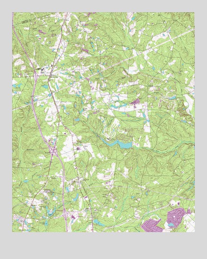
Blythewood, SC USGS Topographic Map
Click on map above to begin viewing in our Map Viewer.

This topographic map contains these locations and features:
Feature Name Type Latitude Longitude GNIS ID View Map
Ashbury BranchStreamN34.2385°W80.9748°1220245View Map
Barnnets PondReservoirN34.1891°W80.9551°1237627View Map
Barnnets Pond D-0392 DamDamN34.1885°W80.9548°1237626View Map
Bethel ChurchChurchN34.2157°W80.9779°1220565View Map
BlythewoodPopulated PlaceN34.2143°W80.9740°1245688View Map
Blythewood DivisionCivilN34.2003°W80.9350°1938205View Map
Blythewood Elementary SchoolSchoolN34.2199°W80.9726°1248949View Map
Blythewood Lookout TowerTowerN34.2024°W80.9826°1248951View Map
BoneyPopulated PlaceN34.2457°W80.9637°1231070View Map
Boney CreekStreamN34.2365°W80.9918°1220887View Map
Browns CemeteryCemeteryN34.2126°W80.9248°1221020View Map
Clarks Pond D-0411 DamDamN34.1302°W80.8965°1239110View Map
Columbia - Richland Fire Station Bear CreekBuildingN34.2253°W80.8843°2578438View Map
Columbia Country ClubLocaleN34.1782°W80.9340°1242375View Map
Columbia Richland Fire Department KillianBuildingN34.1356°W80.9459°2578576View Map
Columbia Richland Fire Station BlythewoodBuildingN34.2188°W80.9726°2578649View Map
Covingtons Lake D-0545 DamDamN34.1346°W80.9743°1237615View Map
Crane Creek Church (historical)ChurchN34.1340°W80.9490°1249030View Map
Crescent LakeReservoirN34.1357°W80.9732°1221826View Map
Duke School (historical)SchoolN34.2249°W80.8840°1249053View Map
Elders PondReservoirN34.1471°W80.9078°1222255View Map
Epworth Pines D-0362 DamDamN34.1435°W80.9581°1239111View Map
Flat Branch School (historical)SchoolN34.2435°W80.8984°1249092View Map
Franklin Memorial GardenCemeteryN34.1549°W80.9531°1222541View Map
Free Hope ChurchChurchN34.1404°W80.9870°1249486View Map
Free Hope ChurchChurchN34.1563°W80.9698°1222547View Map
Free Hope School (historical)SchoolN34.1452°W80.9843°1249100View Map
Friendship ChurchChurchN34.1382°W80.9495°1249103View Map
Fuller Pond Dam D-1592DamN34.2285°W80.9481°1239113View Map
Green SpringsPopulated PlaceN34.1288°W80.9043°1249123View Map
Hanbury Junior High SchoolSchoolN34.2174°W80.9795°1223015View Map
Hawkins BranchStreamN34.1538°W80.9931°1223087View Map
Hidden Acres PondReservoirN34.1393°W80.9761°1223153View Map
Holiness ChurchChurchN34.1990°W80.9665°1249148View Map
Hood BranchStreamN34.2168°W80.9123°1249505View Map
Hospitals LakeReservoirN34.1335°W80.9331°1237618View Map
Hospitals Lake D-0413 DamDamN34.1335°W80.9331°1237617View Map
Interchange 22CrossingN34.1357°W80.9643°1228240View Map
Interchange 24CrossingN34.1710°W80.9723°1228241View Map
Interchange 27CrossingN34.2138°W80.9848°1228242View Map
KillianPopulated PlaceN34.1382°W80.9462°1246243View Map
Killian School (historical)SchoolN34.1377°W80.9406°1249182View Map
Lake Ashley D-1590 DamDamN34.2401°W80.9831°1239116View Map
Lake ColumbiaReservoirN34.1752°W80.9261°1237555View Map
Lake Columbia D-0549 DamDamN34.1752°W80.9181°1237554View Map
Langfords CrossroadsPopulated PlaceN34.2082°W80.9076°1249516View Map
Lot BranchStreamN34.1643°W80.9943°1224199View Map
Mount Zion ChurchChurchN34.2157°W80.8851°1249717View Map
North CrossingPopulated PlaceN34.1371°W80.8784°1249250View Map
North PinesPopulated PlaceN34.1482°W80.9748°1249251View Map
North Spring LakeReservoirN34.1352°W80.8965°1239120View Map
North Spring Lake D-0550 DamDamN34.1352°W80.8965°1239119View Map
North SpringsPopulated PlaceN34.1349°W80.8873°1249253View Map
North Springs Elementary SchoolSchoolN34.1415°W80.8862°1249254View Map
Pine View ChurchChurchN34.2365°W80.9695°1250124View Map
Progressive ChurchChurchN34.1463°W80.9348°1225684View Map
Roberts BranchStreamN34.1385°W80.9701°1225911View Map
Roberts PondReservoirN34.1448°W80.9560°1249310View Map
Robertson BranchStreamN34.1704°W80.9934°1225912View Map
Rose CreekPopulated PlaceN34.1404°W80.9004°1249316View Map
Round Top BranchStreamN34.2015°W80.8823°1226052View Map
Round Top ChurchChurchN34.1990°W80.9298°1250476View Map
Round Top School (historical)SchoolN34.2093°W80.9131°1249319View Map
Rymers PondReservoirN34.1940°W80.9523°1226087View Map
Saint Marks ChurchChurchN34.2115°W80.9754°1226196View Map
Saint Mary Church (historical)ChurchN34.1285°W80.9440°1249329View Map
Sand Level ChurchChurchN34.2149°W80.9901°1250753View Map
Sand Level School (historical)SchoolN34.1663°W80.9734°1249337View Map
Sandfield Church (historical)ChurchN34.2204°W80.9387°1249338View Map
Sandhills Post OfficePost OfficeN34.1407°W80.9032°2740119View Map
Shady Grove School (historical)SchoolN34.2165°W80.8851°1249346View Map
SharpPopulated PlaceN34.1743°W80.9506°1231795View Map
Simmons CreekStreamN34.2188°W80.9237°1226630View Map
Simmons CreekStreamN34.2496°W80.9318°1249355View Map
Sorghum BranchStreamN34.1277°W80.9168°1226751View Map
Stevensons LakeReservoirN34.1304°W80.9764°1226886View Map
Stevensons Lake D-0546 DamDamN34.1285°W80.9765°1239127View Map
Sunny Acres PondReservoirN34.1416°W80.9757°1226964View Map
Town of BlythewoodCivilN34.2121°W80.9921°2405291View Map
WNOK-FM (Columbia)TowerN34.1518°W80.9098°1252473View Map
Woodlawn CemeteryCemeteryN34.1535°W80.9537°1251498View Map

Note: Coordinates in the location and feature list above are referenced to NAD83 datum.


Copyright (C) 2008-2025 Ryan Niemi / Sunset Dynamics ... All Rights Reserved