TopoQuest Logo
Do you find TopoQuest useful?
Help keep TopoQuest running and adding new maps/features by donating!
Bitcoin:  19c7KJd3qBynnjoSw5npx9KScwjBe4ifkT
Litecoin:  LXs6TkuXGGXo1vDsWCkWVdjQX94eUKd6ui
Home View Maps Find Maps Find Places Resources & Links


Eastover, South Carolina Topographic Map

USGS Map Title: Eastover, SC
USGS Map MRC: 33080H6
DRG (GeoTIFF) Download: o33080h6.tif


Neighboring USGS Topographic Map Quads:


  Messers Pond, SC  
34080A7
 

  Leesburg, SC  
34080A6
 

  Rembert, SC  
34080A5
 

  Congaree, SC  
33080H7
 

  Eastover, SC  
33080H6
 

  Wedgefield, SC  
33080H5
 

  Gadsden, SC  
33080G7
 

  Wateree, SC  
33080G6
 

  Poinsett State Park, SC  
33080G5


Map MRC Location:

N34°
W81°
N34°
W80°
H8 H7 H6 H5 H4 H3 H2 H1
G8 G7 G6 G5 G4 G3 G2 G1
F8 F7 F6 F5 F4 F3 F2 F1
E8 E7 E6 E5 E4 E3 E2 E1
D8 D7 D6 D5 D4 D3 D2 D1
C8 C7 C6 C5 C4 C3 C2 C1
B8 B7 B6 B5 B4 B3 B2 B1
A8 A7 A6 A5 A4 A3 A2 A1
N33°
W81°
N33°
W80°

Eastover, SC USGS 1:24K Topographic Map Preview:
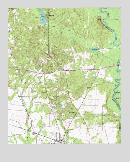
Eastover, SC USGS Topographic Map
Click on map above to begin viewing in our Map Viewer.

This topographic map contains these locations and features:
Feature Name Type Latitude Longitude GNIS ID View Map
Antioch ChurchChurchN33.9313°W80.7154°1249442View Map
Antioch SchoolSchoolN33.9174°W80.7220°1220222View Map
Antioch School (historical)SchoolN33.9304°W80.7156°1248905View Map
Cates PondReservoirN33.9558°W80.6861°1221400View Map
Clarkson Mission ChurchChurchN33.9179°W80.6826°1249464View Map
Colonels CreekStreamN33.9479°W80.6284°1221692View Map
Columbia - Richland Fire Department EastoverBuildingN33.8764°W80.6946°2578517View Map
Cooks MountSummitN33.9882°W80.6481°1247374View Map
Cove LakeLakeN33.9291°W80.6306°1221782View Map
Crossroad SchoolSchoolN33.9443°W80.6895°1249472View Map
Crossroads Church (historical)ChurchN33.9435°W80.6890°1249033View Map
Daughters of Zion ChurchChurchN33.9935°W80.7051°1249474View Map
Daughters of Zion School (historical)SchoolN33.9927°W80.7051°1249038View Map
EastoverPopulated PlaceN33.8768°W80.6929°1222202View Map
Eastover DivisionCivilN33.9142°W80.6771°1938254View Map
Freemans Pond D-0598 DamDamN33.9335°W80.6615°1239112View Map
Garners Ferry (historical)CrossingN33.9468°W80.6279°1244533View Map
Garners Quarter (historical)Populated PlaceN33.9432°W80.6426°1249110View Map
Glorious ChurchChurchN33.9568°W80.7459°1249491View Map
Good Hope ChurchChurchN33.9399°W80.7112°1249492View Map
Goodwill ChurchChurchN33.9432°W80.6593°1249494View Map
Goodwill PondReservoirN33.9617°W80.6540°1237582View Map
Goodwill Pond D-0597 DamDamN33.9602°W80.6531°1237581View Map
Gum Springs School (historical)SchoolN33.9563°W80.7037°1249126View Map
Happy Times Pond D-0596 DamDamN33.9202°W80.6948°1237583View Map
Hickory Top FarmLocaleN33.9533°W80.7453°2652402View Map
Krelldire PondReservoirN33.9329°W80.7026°1249515View Map
McLeod ChurchChurchN33.9404°W80.7043°1224423View Map
Morris Pond D-0116 DamDamN33.9318°W80.6915°1239118View Map
Mount Zion ChurchChurchN33.8857°W80.6840°1249710View Map
Mount Zion School (historical)SchoolN33.9035°W80.6770°1249241View Map
Murray Lake D-0595 DamDamN33.9849°W80.7084°1237564View Map
Murray PondReservoirN33.9914°W80.7110°1237565View Map
Myers LakeLakeN33.9395°W80.6260°1249769View Map
Richland ChurchChurchN33.8827°W80.6968°1250373View Map
Richland County Chain Gang Camp Number 1LocaleN33.9024°W80.6984°1225864View Map
Saint Thomas ChurchChurchN33.9035°W80.6768°1250710View Map
Shiloh ChurchChurchN33.9263°W80.6623°1250863View Map
Shiloh SchoolSchoolN33.9002°W80.6693°1226579View Map
Town of EastoverCivilN33.8779°W80.6949°2406416View Map
Wateree Gun ClubLocaleN33.9443°W80.6634°1249407View Map
Williams LakeReservoirN33.9202°W80.6948°1237584View Map
Wilson Mill PondReservoirN33.9997°W80.7446°1227640View Map

Note: Coordinates in the location and feature list above are referenced to NAD83 datum.


Copyright (C) 2008-2024 Ryan Niemi / Sunset Dynamics ... All Rights Reserved