TopoQuest Logo
Do you find TopoQuest useful?
Help keep TopoQuest running and adding new maps/features by donating!
Bitcoin:  19c7KJd3qBynnjoSw5npx9KScwjBe4ifkT
Litecoin:  LXs6TkuXGGXo1vDsWCkWVdjQX94eUKd6ui
Home View Maps Find Maps Find Places Resources & Links


Metaline Falls, Washington Topographic Map

USGS Map Title: Metaline Falls, WA
USGS Map MRC: 48117G3
DRG (GeoTIFF) Download: o48117g3.tif


Neighboring USGS Topographic Map Quads:


  Abercrombie Mountain, WA  
48117H4
 

  Boundary Dam, WA  
48117H3
 

  Gypsy Peak, WA  
48117H2
 

  Metaline, WA  
48117G4
 

  Metaline Falls, WA  
48117G3
 

  Pass Creek, WA  
48117G2
 

  Ione, WA  
48117F4
 

  Scotchman Lake, WA  
48117F3
 

  Monumental Mountain, WA  
48117F2


Map MRC Location:

N49°
W118°
N49°
W117°
H8 H7 H6 H5 H4 H3 H2 H1
G8 G7 G6 G5 G4 G3 G2 G1
F8 F7 F6 F5 F4 F3 F2 F1
E8 E7 E6 E5 E4 E3 E2 E1
D8 D7 D6 D5 D4 D3 D2 D1
C8 C7 C6 C5 C4 C3 C2 C1
B8 B7 B6 B5 B4 B3 B2 B1
A8 A7 A6 A5 A4 A3 A2 A1
N48°
W118°
N48°
W117°

Metaline Falls, WA USGS 1:24K Topographic Map Preview:
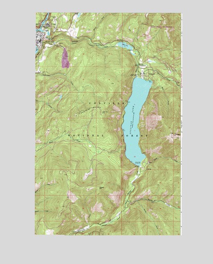
Metaline Falls, WA USGS Topographic Map
Click on map above to begin viewing in our Map Viewer.

This topographic map contains these locations and features:
Feature Name Type Latitude Longitude GNIS ID View Map
Congregation United Church of ChristChurchN48.8627°W117.3734°2609661View Map
Cutter TheaterBuildingN48.8613°W117.3748°2608215View Map
Elk CreekStreamN48.8563°W117.2936°1529522View Map
Grandview FlatsFlatN48.8691°W117.3583°1520200View Map
Hall CreekStreamN48.8335°W117.2766°1520460View Map
Hall MountainSummitN48.8066°W117.2569°1520467View Map
Hall Mountain LookoutLocaleN48.8066°W117.2569°1529969View Map
Harvey CreekStreamN48.7880°W117.2866°1520590View Map
Ione-Metaline Falls DivisionCivilN48.7671°W117.2662°1939524View Map
Lime LakeLakeN48.8742°W117.3376°1522112View Map
MaitlenLocaleN48.7538°W117.3308°1529519View Map
Metaline FallsPopulated PlaceN48.8638°W117.3725°1523023View Map
Metaline Falls City HallBuildingN48.8625°W117.3708°2610583View Map
Metaline Falls Post OfficePost OfficeN48.8620°W117.3705°2606981View Map
Metaline Falls Sewage Treatment PlantLocaleN48.8635°W117.3640°2610697View Map
Metalines Community LibraryBuildingN48.8610°W117.3748°2610157View Map
Mill PondReservoirN48.8565°W117.2988°1523173View Map
Mill Pond CampgroundLocaleN48.8538°W117.2916°1529521View Map
Mill Pond DamDamN48.8566°W117.3061°1531953View Map
Noisy CreekStreamN48.7919°W117.2841°1523704View Map
Noisy Creek CampgroundLocaleN48.7905°W117.2844°1523705View Map
North Fork Sullivan CreekStreamN48.8599°W117.3286°1523852View Map
Outlet CreekStreamN48.8466°W117.2889°1524103View Map
Paupac CreekStreamN48.7705°W117.2980°1524262View Map
Pend Oreille County Fire District 2BuildingN48.8606°W117.3723°2619749View Map
Pend Oreille County Fire District 2BuildingN48.8637°W117.3736°2619751View Map
Pend Oreille County Fire District 2BuildingN48.8497°W117.2867°2619554View Map
Pend Oreille River BridgeBridgeN48.8652°W117.3731°2608008View Map
Pend Oreille VillagePopulated PlaceN48.8683°W117.3658°1524319View Map
Rocky ForkStreamN48.7699°W117.2880°1525169View Map
Saint Joseph's Catholic ChurchChurchN48.8596°W117.3748°2608723View Map
Sand Creek MountainSummitN48.8188°W117.3322°1525416View Map
Selkirk Elementary SchoolSchoolN48.8612°W117.3740°1530557View Map
Snyder HillSummitN48.7763°W117.3205°1526067View Map
Sullivan CreekStreamN48.8646°W117.3677°1526680View Map
Sullivan Creek Campground Number 1LocaleN48.8383°W117.2664°1533233View Map
Sullivan LakeReservoirN48.8150°W117.2900°1526681View Map
Sullivan Lake CampgroundLocaleN48.8399°W117.2811°1526682View Map
Sullivan Lake DamDamN48.8399°W117.2894°1531954View Map
Sullivan Lake Ranger StationLocaleN48.8399°W117.2883°1526683View Map
Sullivan Lake State AirportAirportN48.8424°W117.2839°1533841View Map
Town of Metaline FallsCivilN48.8616°W117.3707°2412990View Map
Upper Sand Creek LookoutLocaleN48.8171°W117.3414°1530016View Map
Washington RockSummitN48.8674°W117.3744°1527831View Map
Wolf LakeLakeN48.8276°W117.3534°1529520View Map

Note: Coordinates in the location and feature list above are referenced to NAD83 datum.


Copyright (C) 2008-2024 Ryan Niemi / Sunset Dynamics ... All Rights Reserved