TopoQuest Logo
Do you find TopoQuest useful?
Help keep TopoQuest running and adding new maps/features by donating!
Bitcoin:  19c7KJd3qBynnjoSw5npx9KScwjBe4ifkT
Litecoin:  LXs6TkuXGGXo1vDsWCkWVdjQX94eUKd6ui
Home View Maps Find Maps Find Places Resources & Links


Mexia, Alabama Topographic Map

USGS Map Title: Mexia, AL
USGS Map MRC: 31087E4
DRG (GeoTIFF) Download: o31087e4.tif


Neighboring USGS Topographic Map Quads:


  Chance, AL  
31087F5
 

  Franklin, AL  
31087F4
 

  Natchez, AL  
31087F3
 

  Claiborne, AL  
31087E5
 

  Mexia, AL  
31087E4
 

  Monroeville, AL  
31087E3
 

  Flynns Lake, AL  
31087D5
 

  Frisco City, AL  
31087D4
 

  Excel, AL  
31087D3


Map MRC Location:

N32°
W88°
N32°
W87°
H8 H7 H6 H5 H4 H3 H2 H1
G8 G7 G6 G5 G4 G3 G2 G1
F8 F7 F6 F5 F4 F3 F2 F1
E8 E7 E6 E5 E4 E3 E2 E1
D8 D7 D6 D5 D4 D3 D2 D1
C8 C7 C6 C5 C4 C3 C2 C1
B8 B7 B6 B5 B4 B3 B2 B1
A8 A7 A6 A5 A4 A3 A2 A1
N31°
W88°
N31°
W87°

Mexia, AL USGS 1:24K Topographic Map Preview:
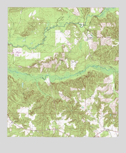
Mexia, AL USGS Topographic Map
Click on map above to begin viewing in our Map Viewer.

This topographic map contains these locations and features:
Feature Name Type Latitude Longitude GNIS ID View Map
Antioch Baptist Church of Tunnel SpringsChurchN31.5956°W87.4071°2580506View Map
Barbara Locklin Baptist ChurchChurchN31.5132°W87.4914°151455View Map
Bradley Mill CreekStreamN31.6071°W87.4458°114814View Map
Carry Mount Baptist ChurchChurchN31.5818°W87.4297°154590View Map
Carry Mount CemeteryCemeteryN31.5824°W87.4297°1730549View Map
FountainPopulated PlaceN31.5946°W87.4089°118541View Map
Fountain ChurchChurchN31.5954°W87.4072°154591View Map
Graham BridgeBridgeN31.6085°W87.4142°136528View Map
Gray CreekStreamN31.5896°W87.4636°136529View Map
HixonPopulated PlaceN31.5729°W87.4261°120156View Map
Hixon Lookout TowerTowerN31.5732°W87.4400°164345View Map
Holly Mill CreekStreamN31.6107°W87.4205°120276View Map
Ikner Bridge (historical)BridgeN31.6004°W87.4583°136540View Map
LimestoneLocaleN31.5674°W87.3833°136553View Map
Lower Bridge (historical)BridgeN31.5879°W87.4944°136557View Map
MexiaPopulated PlaceN31.5071°W87.3883°122677View Map
Mexia Apostolic Overcoming Holiness ChurchChurchN31.5011°W87.3759°2580510View Map
Mexia Baptist ChurchChurchN31.5082°W87.3908°151250View Map
Mexia CemeteryCemeteryN31.5079°W87.3914°1805615View Map
Mexia Post OfficePost OfficeN31.5041°W87.3961°167035View Map
Mexia Volunteer Fire DepartmentBuildingN31.5041°W87.3959°2691165View Map
Mill CreekStreamN31.5577°W87.4703°122757View Map
Mineral SpringsSpringN31.5141°W87.4211°136572View Map
Monroeville DivisionCivilN31.5120°W87.4077°165900View Map
Mount Rose Missionary Baptist ChurchChurchN31.5088°W87.4817°155397View Map
Old SalemPopulated PlaceN31.5396°W87.4061°1730579View Map
Old Salem Baptist ChurchChurchN31.5410°W87.4092°154130View Map
Old Salem CemeteryCemeteryN31.5410°W87.4094°1730580View Map
Perdue HillPopulated PlaceN31.5141°W87.4933°152870View Map
Perdue Hill Post OfficePost OfficeN31.5161°W87.4965°167048View Map
Perdue Hill Presbyterian ChurchChurchN31.5129°W87.4911°151456View Map
Saint Thomas Church (historical)ChurchN31.6082°W87.4733°136626View Map
Salem ChurchChurchN31.5068°W87.3883°154588View Map
Victoria ChurchChurchN31.6027°W87.4083°153843View Map
W Sam Carpenters DamDamN31.5502°W87.4833°129886View Map
W Sam Carpenters LakeReservoirN31.5504°W87.4830°129885View Map
Wiggins CemeteryCemeteryN31.5129°W87.3800°154589View Map

Note: Coordinates in the location and feature list above are referenced to NAD83 datum.


Copyright (C) 2008-2024 Ryan Niemi / Sunset Dynamics ... All Rights Reserved