TopoQuest Logo
Do you find TopoQuest useful?
Help keep TopoQuest running and adding new maps/features by donating!
Bitcoin:  19c7KJd3qBynnjoSw5npx9KScwjBe4ifkT
Litecoin:  LXs6TkuXGGXo1vDsWCkWVdjQX94eUKd6ui
Home View Maps Find Maps Find Places Resources & Links


Claiborne, Alabama Topographic Map

USGS Map Title: Claiborne, AL
USGS Map MRC: 31087E5
DRG (GeoTIFF) Download: o31087e5.tif


Neighboring USGS Topographic Map Quads:


  Whatley, AL  
31087F6
 

  Chance, AL  
31087F5
 

  Franklin, AL  
31087F4
 

  Suggsville, AL  
31087E6
 

  Claiborne, AL  
31087E5
 

  Mexia, AL  
31087E4
 

  Gainestown, AL  
31087D6
 

  Flynns Lake, AL  
31087D5
 

  Frisco City, AL  
31087D4


Map MRC Location:

N32°
W88°
N32°
W87°
H8 H7 H6 H5 H4 H3 H2 H1
G8 G7 G6 G5 G4 G3 G2 G1
F8 F7 F6 F5 F4 F3 F2 F1
E8 E7 E6 E5 E4 E3 E2 E1
D8 D7 D6 D5 D4 D3 D2 D1
C8 C7 C6 C5 C4 C3 C2 C1
B8 B7 B6 B5 B4 B3 B2 B1
A8 A7 A6 A5 A4 A3 A2 A1
N31°
W88°
N31°
W87°

Claiborne, AL USGS 1:24K Topographic Map Preview:
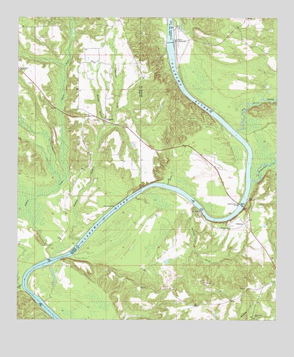
Claiborne, AL USGS Topographic Map
Click on map above to begin viewing in our Map Viewer.

This topographic map contains these locations and features:
Feature Name Type Latitude Longitude GNIS ID View Map
Alabama HeightsCliffN31.5427°W87.5208°136476View Map
Barefield Landing (historical)LocaleN31.5849°W87.5319°136481View Map
Bedsole Farm Airport (historical)AirportN31.5606°W87.5321°129406View Map
Big Flat CreekStreamN31.5779°W87.5194°114280View Map
Brewers Store (historical)LocaleN31.5793°W87.5728°133586View Map
Campbells Mills (historical)LocaleN31.5582°W87.5892°133591View Map
Cedar CreekStreamN31.5143°W87.6225°115748View Map
Cedar Creek Landing (historical)LocaleN31.5168°W87.6222°133595View Map
Choctaw CreekStreamN31.5329°W87.5950°116080View Map
ClaibornePopulated PlaceN31.5402°W87.5155°116160View Map
Claiborne BluffCliffN31.5418°W87.5250°154132View Map
Claiborne CemeteryCemeteryN31.5465°W87.5125°155396View Map
Claiborne Ferry (historical)CrossingN31.5468°W87.5175°136503View Map
Claiborne LakeReservoirN31.6149°W87.5522°116161View Map
Claiborne LandingLocaleN31.5502°W87.5139°156182View Map
Claiborne Lock and DamDamN31.6148°W87.5518°116162View Map
Claiborne State DockLocaleN31.5452°W87.5372°136504View Map
Claiborne-Murphy BridgeBridgeN31.5474°W87.5169°116163View Map
Galliard CreekStreamN31.5468°W87.5392°118792View Map
Gibbons Landing (historical)LocaleN31.5529°W87.5597°136524View Map
GosportPopulated PlaceN31.5827°W87.5836°119188View Map
Gosport LandingLocaleN31.5468°W87.5786°156421View Map
Harris Landing (historical)LocaleN31.5252°W87.6044°136535View Map
House of PrayerChurchN31.5936°W87.5825°2580397View Map
Lamberts Gin (historical)LocaleN31.5127°W87.5400°136550View Map
Lees Landing (historical)LocaleN31.6163°W87.5533°136551View Map
Lees Store (historical)LocaleN31.6246°W87.5769°133661View Map
Limestone CreekStreamN31.5582°W87.5125°121647View Map
Limestone Landing (historical)LocaleN31.5696°W87.5117°136554View Map
Lisbon Landing (historical)LocaleN31.6046°W87.5514°136555View Map
Little Mill CreekStreamN31.5910°W87.5017°121816View Map
Little Rock Baptist ChurchChurchN31.6032°W87.6247°2580395View Map
Mabel Bedsole Ward Trust LakeReservoirN31.5241°W87.5530°129880View Map
Mabel Bedsole Ward Trust Lake DamDamN31.5235°W87.5550°129879View Map
Mackey BranchStreamN31.5738°W87.5869°122180View Map
MacKey Branch Church Number 2ChurchN31.6035°W87.6244°152194View Map
Mackey Branch Church Number TwoChurchN31.6032°W87.6247°154554View Map
Mackey Branch Number One Baptist ChurchChurchN31.5821°W87.5811°155337View Map
Mackey Branch SchoolSchoolN31.5829°W87.5825°133664View Map
Masons Ferry (historical)CrossingN31.5266°W87.6017°136568View Map
McConnico CemeteryCemeteryN31.5018°W87.5108°122491View Map
Mistress Gray BarBarN31.5074°W87.6142°136573View Map
Mount Zion ChurchChurchN31.5382°W87.5239°123445View Map
Nancy Hall LandingLocaleN31.5266°W87.5989°136586View Map
Pigeon CreekStreamN31.5252°W87.6092°124713View Map
Pigeon Creek BarBarN31.5241°W87.6094°136601View Map
Pure Gospel of Jesus Christ ChurchChurchN31.5936°W87.5825°2580396View Map
River Heritage MuseumBuildingN31.6156°W87.5487°2579881View Map
Roane LandingLocaleN31.5010°W87.6086°133691View Map
Strodes Landing (historical)LocaleN31.5568°W87.5542°136639View Map
Tri - Community Fire DepartmentBuildingN31.5836°W87.5916°2691501View Map
Zion ChurchChurchN31.5827°W87.5864°164153View Map

Note: Coordinates in the location and feature list above are referenced to NAD83 datum.


Copyright (C) 2008-2024 Ryan Niemi / Sunset Dynamics ... All Rights Reserved