TopoQuest Logo
Do you find TopoQuest useful?
Help keep TopoQuest running and adding new maps/features by donating!
Bitcoin:  19c7KJd3qBynnjoSw5npx9KScwjBe4ifkT
Litecoin:  LXs6TkuXGGXo1vDsWCkWVdjQX94eUKd6ui
Home View Maps Find Maps Find Places Resources & Links


Michigan City West, Indiana Topographic Map

USGS Map Title: Michigan City West, IN
USGS Map MRC: 41086F8
DRG (GeoTIFF) Download: o41086f8.tif


Neighboring USGS Topographic Map Quads:


  New Buffalo West, MI  
41086G7
 

  Dune Acres, IN  
41087F1
 

  Michigan City West, IN  
41086F8
 

  Michigan City East, IN  
41086F7
 

  Chesterton, IN  
41087E1
 

  Westville, IN  
41086E8
 

  LaPorte West, IN  
41086E7


Map MRC Location:

N42°
W87°
N42°
W86°
H8 H7 H6 H5 H4 H3 H2 H1
G8 G7 G6 G5 G4 G3 G2 G1
F8 F7 F6 F5 F4 F3 F2 F1
E8 E7 E6 E5 E4 E3 E2 E1
D8 D7 D6 D5 D4 D3 D2 D1
C8 C7 C6 C5 C4 C3 C2 C1
B8 B7 B6 B5 B4 B3 B2 B1
A8 A7 A6 A5 A4 A3 A2 A1
N41°
W87°
N41°
W86°

Michigan City West, IN USGS 1:24K Topographic Map Preview:
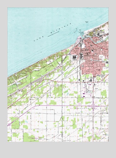
Michigan City West, IN USGS Topographic Map
Click on map above to begin viewing in our Map Viewer.

This topographic map contains these locations and features:
Feature Name Type Latitude Longitude GNIS ID View Map
Ames FieldParkN41.7014°W86.8967°430137View Map
Barker Junior High SchoolSchoolN41.6859°W86.8931°430492View Map
Beverly ShoresPopulated PlaceN41.6925°W86.9775°430998View Map
Beverly Shores Fire DepartmentBuildingN41.6738°W86.9867°2701371View Map
Beverly Shores Volunteer Fire DepartmentBuildingN41.6738°W86.9867°2625588View Map
Brown DitchCanalN41.6939°W86.9483°2575886View Map
Carver DitchCanalN41.6437°W86.9423°432199View Map
Central Elementary SchoolSchoolN41.7142°W86.8961°449881View Map
City of Michigan CityCivilN41.7128°W86.8757°2395110View Map
Cleveland ParkParkN41.7103°W86.8834°432648View Map
Coolspring Elementary SchoolSchoolN41.6520°W86.8767°447395View Map
Dunes PlazaLocaleN41.6806°W86.8886°449464View Map
Eastport Elementary SchoolSchoolN41.7117°W86.8836°449888View Map
Edgewood Elementary SchoolSchoolN41.6917°W86.8864°449889View Map
Franciscan Saint Anthony MemorialHospitalN41.7065°W86.9006°442485View Map
Gardena PlaygroundParkN41.6987°W86.8820°434949View Map
Garfield Special SchoolSchoolN41.7098°W86.9056°449898View Map
Gill FieldParkN41.7087°W86.8945°435073View Map
Greenwood CemeteryCemeteryN41.7036°W86.8834°435470View Map
Hanson ParkParkN41.7181°W86.8886°435703View Map
Harrison SchoolSchoolN41.7200°W86.8903°435802View Map
Indiana State PrisonBuildingN41.7034°W86.9155°2757191View Map
Isaac C Elston High SchoolSchoolN41.7103°W86.8939°449891View Map
Jefferson Elementary SchoolSchoolN41.6973°W86.8953°449905View Map
Kieffer Gruenke DitchCanalN41.6620°W86.8948°437288View Map
Kintzele DitchCanalN41.6920°W86.9314°437348View Map
Knapp Elementary SchoolSchoolN41.6956°W86.9061°449908View Map
La Porte County Sheriff's Office Michigan CityBuildingN41.7189°W86.9037°2758087View Map
LaPorte County Emergency Medical Services - Michigan CityBuildingN41.6951°W86.8958°2719330View Map
Marquette High SchoolSchoolN41.7109°W86.9025°438643View Map
Marquette MallLocaleN41.6820°W86.8961°449463View Map
Marsh Elementary SchoolSchoolN41.7070°W86.8914°449916View Map
Memorial HospitalHospitalN41.7170°W86.9003°438991View Map
Michigan CityPopulated PlaceN41.7075°W86.8950°439078View Map
Michigan City Fire Department Station 1BuildingN41.7100°W86.9057°2625571View Map
Michigan City Fire Department Station 4BuildingN41.6820°W86.8847°2626248View Map
Michigan City HarborHarborN41.7273°W86.9128°452979View Map
Michigan City Harbor Breakwater LightLocaleN41.7300°W86.9139°452978View Map
Michigan City Harbor Breakwater South LightLocaleN41.7267°W86.9164°452977View Map
Michigan City Harbor East Pierhead LightLocaleN41.7292°W86.9120°452976View Map
Michigan City Harbor West Pierhead LightLocaleN41.7264°W86.9100°452975View Map
Michigan City Municipal Airport (historical)AirportN41.6750°W86.8834°449265View Map
Michigan City Police DepartmentBuildingN41.7201°W86.9040°2758047View Map
Michigan City Yacht ClubLocaleN41.7228°W86.9067°446945View Map
Mount BaldySummitN41.7111°W86.9250°1852053View Map
Mullen Elementary SchoolSchoolN41.7284°W86.8850°439869View Map
Old North ChurchChurchN41.6786°W86.9928°440580View Map
Outer BasinHarborN41.7259°W86.9078°446947View Map
Outer Basin LightLocaleN41.7253°W86.9086°452974View Map
Park Elementary SchoolSchoolN41.7117°W86.9156°449925View Map
Pine Township Volunteer Fire DepartmentBuildingN41.6827°W86.9598°2625826View Map
Pullman FieldParkN41.7145°W86.9109°441638View Map
Saint Anns ChurchChurchN41.6725°W86.9823°442475View Map
Saint Johns ChurchChurchN41.6845°W86.8953°442604View Map
Saint Mary Elementary SchoolSchoolN41.7106°W86.9031°449939View Map
Saint Paul Christian Day School and KindergartenSchoolN41.7134°W86.8986°449940View Map
Saint Stanislaus CemeteryCemeteryN41.7017°W86.8803°442838View Map
Saint Stanislaus SchoolSchoolN41.7078°W86.8984°442840View Map
Spychalskis PondReservoirN41.6318°W86.8767°444028View Map
Town of Beverly ShoresCivilN41.6911°W86.9767°2396590View Map
Town of PinesPopulated PlaceN41.6820°W86.9603°444832View Map
Town of Town of PinesCivilN41.6882°W86.9518°2397698View Map
Township of PineCivilN41.6520°W86.9678°453739View Map
Trail CreekStreamN41.7242°W86.9089°444852View Map
Walter HospitalHospitalN41.6856°W86.8931°445445View Map
Washington ParkParkN41.7259°W86.9000°445504View Map
Washington Park MarinaLocaleN41.7259°W86.9048°446946View Map
WIMS-AM (Michigan City)TowerN41.6739°W86.9328°448403View Map
Zilla ParkParkN41.7070°W86.8914°446437View Map

Note: Coordinates in the location and feature list above are referenced to NAD83 datum.


Copyright (C) 2008-2024 Ryan Niemi / Sunset Dynamics ... All Rights Reserved