TopoQuest Logo
Do you find TopoQuest useful?
Help keep TopoQuest running and adding new maps/features by donating!
Bitcoin:  19c7KJd3qBynnjoSw5npx9KScwjBe4ifkT
Litecoin:  LXs6TkuXGGXo1vDsWCkWVdjQX94eUKd6ui
Home View Maps Find Maps Find Places Resources & Links


Michigan City East, Indiana Topographic Map

USGS Map Title: Michigan City East, IN
USGS Map MRC: 41086F7
DRG (GeoTIFF) Download: o41086f7.tif


Neighboring USGS Topographic Map Quads:


  New Buffalo West, MI  
41086G7
 

  New Buffalo East, MI  
41086G6
 

  Michigan City West, IN  
41086F8
 

  Michigan City East, IN  
41086F7
 

  Springville, IN  
41086F6
 

  Westville, IN  
41086E8
 

  LaPorte West, IN  
41086E7
 

  LaPorte East, IN  
41086E6


Map MRC Location:

N42°
W87°
N42°
W86°
H8 H7 H6 H5 H4 H3 H2 H1
G8 G7 G6 G5 G4 G3 G2 G1
F8 F7 F6 F5 F4 F3 F2 F1
E8 E7 E6 E5 E4 E3 E2 E1
D8 D7 D6 D5 D4 D3 D2 D1
C8 C7 C6 C5 C4 C3 C2 C1
B8 B7 B6 B5 B4 B3 B2 B1
A8 A7 A6 A5 A4 A3 A2 A1
N41°
W87°
N41°
W86°

Michigan City East, IN USGS 1:24K Topographic Map Preview:
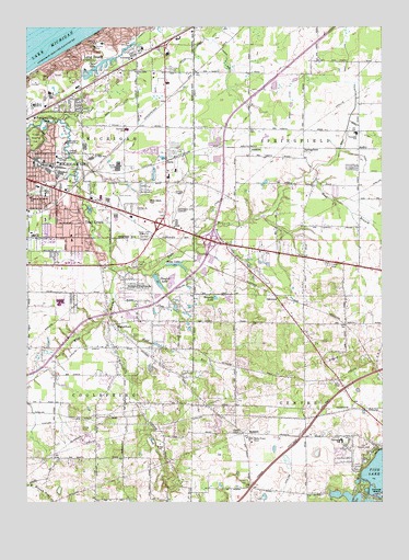
Michigan City East, IN USGS Topographic Map
Click on map above to begin viewing in our Map Viewer.

This topographic map contains these locations and features:
Feature Name Type Latitude Longitude GNIS ID View Map
AmblerPopulated PlaceN41.7159°W86.7967°430129View Map
AndryPopulated PlaceN41.7178°W86.7581°430173View Map
Beck DitchCanalN41.7262°W86.8495°430688View Map
Bock ArmCanalN41.7484°W86.8073°431276View Map
Bosserman CreekStreamN41.6920°W86.8156°431362View Map
Browdy LakeLakeN41.6785°W86.8088°431591View Map
Brown DitchCanalN41.7300°W86.7822°431621View Map
Bull DitchCanalN41.7106°W86.7775°431788View Map
Center Township Volunteer Fire DepartmentBuildingN41.6427°W86.7586°2625595View Map
Clare LakeLakeN41.7402°W86.8492°432547View Map
Coolspring Township Volunteer Fire DepartmentBuildingN41.6661°W86.8379°2626376View Map
Cross CemeteryCemeteryN41.6689°W86.8384°433184View Map
DavisPopulated PlaceN41.7148°W86.8261°433339View Map
Dingler LakeReservoirN41.6830°W86.8288°433563View Map
Dingler Lake DamDamN41.6839°W86.8295°448668View Map
East Branch Trail CreekStreamN41.6867°W86.8439°433870View Map
Elks Country ClubLocaleN41.6400°W86.7556°452313View Map
Freyer DitchCanalN41.7020°W86.8675°434837View Map
Grace Bible ChurchChurchN41.7384°W86.8367°435257View Map
Gropp DitchCanalN41.7228°W86.7572°435521View Map
Joy Elementary SchoolSchoolN41.6953°W86.8725°449907View Map
Kimball DitchCanalN41.7489°W86.8331°437305View Map
Krueger Memorial ParkParkN41.7203°W86.8725°437465View Map
Long BeachPopulated PlaceN41.7389°W86.8570°438243View Map
Long Beach Elementary SchoolSchoolN41.7453°W86.8481°447393View Map
Long Beach Fire DepartmentBuildingN41.7461°W86.8510°2625579View Map
Long Beach Police DepartmentBuildingN41.7459°W86.8508°2758140View Map
Lows CemeteryCemeteryN41.6581°W86.8203°438385View Map
Lubke ArmCanalN41.7412°W86.8047°438387View Map
Martin T Krueger Junior High SchoolSchoolN41.7156°W86.8520°449909View Map
MerrickPopulated PlaceN41.7375°W86.8153°446711View Map
Michigan City Fire Department Administration Offices and Training CenterBuildingN41.7090°W86.8687°2626245View Map
Michigan City Fire Department Station 2BuildingN41.7259°W86.8729°2626572View Map
Michigan City Fire Department Station 3BuildingN41.7056°W86.8250°2626247View Map
Michigan City Municipal Airport-Phillips FieldAirportN41.7042°W86.8234°449264View Map
Moon DitchCanalN41.7139°W86.7556°439383View Map
Motts ParkParkN41.7045°W86.8345°449920View Map
Niemann Elementary SchoolSchoolN41.7231°W86.8403°449923View Map
Norm's AirparkAirportN41.6844°W86.7659°2676928View Map
North Arm Beck DitchCanalN41.7345°W86.8364°440211View Map
OakwoodPopulated PlaceN41.6784°W86.7864°440484View Map
Ohms LakeLakeN41.6877°W86.8231°440524View Map
Orchard HighlandsPopulated PlaceN41.6828°W86.8359°440684View Map
Otter CreekStreamN41.7256°W86.8631°440740View Map
Pottawattamie Country ClubLocaleN41.7198°W86.8614°452384View Map
Pottawattamie ParkPopulated PlaceN41.7225°W86.8670°1699783View Map
Pottawattamie ParkParkN41.7209°W86.8667°441501View Map
Queen of All Saints SchoolSchoolN41.7053°W86.8736°441692View Map
Riley SchoolSchoolN41.7062°W86.8684°442038View Map
Saint Andrews ChurchChurchN41.7417°W86.8381°442468View Map
Sharp CemeteryCemeteryN41.6448°W86.8559°443301View Map
South Arm Beck DitchCanalN41.7278°W86.8361°443778View Map
SpringfieldPopulated PlaceN41.7153°W86.7775°444009View Map
Springfield Elementary SchoolSchoolN41.7223°W86.7589°447394View Map
Springfield Township Volunteer Fire DepartmentBuildingN41.7099°W86.7579°2626016View Map
SummitPopulated PlaceN41.6431°W86.7975°444392View Map
Swan Lake Memorial GardensCemeteryN41.6941°W86.8331°444459View Map
Town of Long BeachCivilN41.7494°W86.8562°2396723View Map
Town of Pottawattamie ParkCivilN41.7233°W86.8671°2396865View Map
Town of Trail CreekCivilN41.6963°W86.8555°2397700View Map
Township of CenterCivilN41.6397°W86.7555°453185View Map
Township of CoolspringCivilN41.6510°W86.8747°453247View Map
Township of MichiganCivilN41.7276°W86.8746°453621View Map
Township of SpringfieldCivilN41.7197°W86.7582°453867View Map
Trail CreekPopulated PlaceN41.6984°W86.8592°444853View Map
WaterfordPopulated PlaceN41.6714°W86.8450°445536View Map
Waterford CreekStreamN41.6728°W86.8484°445537View Map
West Arm Bull DitchCanalN41.7420°W86.7620°445713View Map
West Branch Trail CreekStreamN41.6864°W86.8442°450491View Map
White DitchCanalN41.7417°W86.8181°445936View Map
WLOI-AM (La Porte)TowerN41.6339°W86.7597°448404View Map
WMBCTowerN41.7148°W86.8614°449956View Map
Wolf RunStreamN41.6742°W86.8459°446254View Map

Note: Coordinates in the location and feature list above are referenced to NAD83 datum.


Copyright (C) 2008-2025 Ryan Niemi / Sunset Dynamics ... All Rights Reserved