TopoQuest Logo
Do you find TopoQuest useful?
Help keep TopoQuest running and adding new maps/features by donating!
Bitcoin:  19c7KJd3qBynnjoSw5npx9KScwjBe4ifkT
Litecoin:  LXs6TkuXGGXo1vDsWCkWVdjQX94eUKd6ui
Home View Maps Find Maps Find Places Resources & Links


Middle Dam, Maine Topographic Map

USGS Map Title: Middle Dam, ME
USGS Map MRC: 44070G8
DRG (GeoTIFF) Download: o44070g8.tif


Neighboring USGS Topographic Map Quads:


  Wilsons Mills, ME  
44071H1
 

  Richardson Pond, ME  
44070H8
 

  Oquossoc, ME  
44070H7
 

  Umbagog Lake North, NH  
44071G1
 

  Middle Dam, ME  
44070G8
 

  Metallak Mountain, ME  
44070G7
 

  Umbagog Lake South, NH  
44071F1
 

  B Pond, ME  
44070F8
 

  Andover, ME  
44070F7


Map MRC Location:

N45°
W71°
N45°
W70°
H8 H7 H6 H5 H4 H3 H2 H1
G8 G7 G6 G5 G4 G3 G2 G1
F8 F7 F6 F5 F4 F3 F2 F1
E8 E7 E6 E5 E4 E3 E2 E1
D8 D7 D6 D5 D4 D3 D2 D1
C8 C7 C6 C5 C4 C3 C2 C1
B8 B7 B6 B5 B4 B3 B2 B1
A8 A7 A6 A5 A4 A3 A2 A1
N44°
W71°
N44°
W70°

Middle Dam, ME USGS 1:24K Topographic Map Preview:
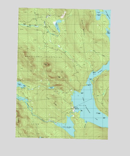
Middle Dam, ME USGS Topographic Map
Click on map above to begin viewing in our Map Viewer.

This topographic map contains these locations and features:
Feature Name Type Latitude Longitude GNIS ID View Map
Ash BrookStreamN44.8576°W70.9767°561312View Map
Bigelow PondLakeN44.8584°W70.9918°562254View Map
Birch BrookStreamN44.8589°W70.9673°562282View Map
Blackcat BrookStreamN44.7664°W70.9059°562520View Map
Carry RidgeRidgeN44.7867°W70.9504°563611View Map
Cranberry CoveBayN44.8720°W70.8901°564458View Map
Cranberry PondLakeN44.8592°W70.9461°564475View Map
Fox PondLakeN44.8528°W70.9581°566520View Map
Halfmoon CoveBayN44.8517°W70.8776°567459View Map
Hardscrabble IslandIslandN44.7753°W70.8854°567608View Map
Horse Beef PointCapeN44.8012°W70.9059°568272View Map
Inlet RidgeRidgeN44.7706°W70.9990°568638View Map
Jackson PointCapeN44.7948°W70.9142°568745View Map
Johnson MountainSummitN44.8207°W70.9582°568931View Map
Long PondLakeN44.8576°W70.9768°570282View Map
Lower Richardson LakeReservoirN44.7786°W70.8934°570538View Map
Middle DamPopulated PlaceN44.7801°W70.9223°571237View Map
Middle DamDamN44.7759°W70.9207°1773561View Map
Moose MountainSummitN44.8084°W70.9383°571606View Map
Old Magalloway TrailTrailN44.8217°W70.9962°572708View Map
Plantation of MagallowayCivilN44.8417°W70.9773°579017View Map
Pond in the RiverLakeN44.7620°W70.9292°573585View Map
Portland PointCapeN44.8056°W70.8995°573696View Map
Rand BrookStreamN44.8253°W70.8759°574019View Map
Richardson LakeReservoirN44.7620°W70.9292°1773562View Map
Rifle PointCapeN44.7767°W70.9123°574209View Map
Skunk PondLakeN44.8575°W70.9836°575534View Map
South MountainSummitN44.8603°W70.9099°575870View Map
Spaulding CoveBayN44.8106°W70.8984°575978View Map
Spirt IslandIslandN44.7709°W70.8776°576059View Map
Sunday PondLakeN44.7988°W70.9526°576528View Map
The NarrowsChannelN44.8131°W70.8929°576855View Map

Note: Coordinates in the location and feature list above are referenced to NAD83 datum.


Copyright (C) 2008-2024 Ryan Niemi / Sunset Dynamics ... All Rights Reserved