TopoQuest Logo
Do you find TopoQuest useful?
Help keep TopoQuest running and adding new maps/features by donating!
Bitcoin:  19c7KJd3qBynnjoSw5npx9KScwjBe4ifkT
Litecoin:  LXs6TkuXGGXo1vDsWCkWVdjQX94eUKd6ui
Home View Maps Find Maps Find Places Resources & Links


Middle Point, Nevada Topographic Map

USGS Map Title: Middle Point, NV
USGS Map MRC: 36114B4
DRG (GeoTIFF) Download: o36114b4.tif


Neighboring USGS Topographic Map Quads:


  Bitter Spring, NV  
36114C5
 

  Echo Bay, NV  
36114C4
 

  Lime Wash, NV  
36114C3
 

  Boulder Canyon, NV  
36114B5
 

  Middle Point, NV  
36114B4
 

  Garrett Butte, NV  
36114B3
 

  Petroglyph Wash, AZ  
36114A5
 

  Bonelli Bay, AZ  
36114A4
 

  The Temple, NV  
36114A3


Map MRC Location:

N37°
W115°
N37°
W114°
H8 H7 H6 H5 H4 H3 H2 H1
G8 G7 G6 G5 G4 G3 G2 G1
F8 F7 F6 F5 F4 F3 F2 F1
E8 E7 E6 E5 E4 E3 E2 E1
D8 D7 D6 D5 D4 D3 D2 D1
C8 C7 C6 C5 C4 C3 C2 C1
B8 B7 B6 B5 B4 B3 B2 B1
A8 A7 A6 A5 A4 A3 A2 A1
N36°
W115°
N36°
W114°

Middle Point, NV USGS 1:24K Topographic Map Preview:
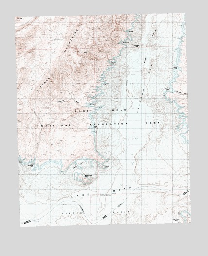
Middle Point, NV USGS Topographic Map
Click on map above to begin viewing in our Map Viewer.

This topographic map contains these locations and features:
Feature Name Type Latitude Longitude GNIS ID View Map
Black MountainsRangeN36.2155°W114.4755°838861View Map
Boathouse CoveBayN36.1589°W114.4980°838953View Map
Bonelli Salt Mine (historical)MineN36.2358°W114.4008°849515View Map
Bonellis House (historical)LocaleN36.1500°W114.4153°851441View Map
Brine SpringSpringN36.1419°W114.4233°846678View Map
Cataract WashStreamN36.2369°W114.3772°839348View Map
Cataract Wash CoveBayN36.2369°W114.3775°863680View Map
Catclaw CoveBayN36.2169°W114.3822°849358View Map
Catclaw WashStreamN36.2444°W114.3775°854392View Map
Cleopatra CoveBayN36.1980°W114.4425°839562View Map
Cleopatra MineLocaleN36.2366°W114.4780°846677View Map
Cleopatra WashStreamN36.2230°W114.4336°839563View Map
Cormorant Rock (historical)PillarN36.2303°W114.4158°863752View Map
Crescent CoveBayN36.1605°W114.4539°839860View Map
Debbies CoveBayN36.1647°W114.5000°849344View Map
East PointCapeN36.1300°W114.3800°4298View Map
East Point BayBayN36.1278°W114.3869°43027View Map
Ebony coveBayN36.1828°W114.4461°849361View Map
Horseshoe CoveBayN36.1805°W114.3764°863740View Map
Jim Jones ReefBarN36.2100°W114.4355°849360View Map
Jimbilnan WildernessReserveN36.2450°W114.4542°2542653View Map
Kendal CoveBayN36.2336°W114.4191°849357View Map
Kitty Coleman RockPillarN36.2469°W114.3994°863356View Map
Lake MeadReservoirN36.1725°W114.4299°7862View Map
Manganese WashStreamN36.1964°W114.4508°845897View Map
Middle PointCapeN36.1636°W114.4397°842088View Map
Middle Point IslandsIslandN36.1530°W114.4544°854529View Map
Miners CoveBayN36.1966°W114.4450°863760View Map
Old Bonelli Ferry (historical)LocaleN36.1486°W114.4147°863137View Map
Rioville (historical)Populated PlaceN36.1503°W114.3994°849516View Map
Rioville Post Office (historical)Post OfficeN36.1503°W114.3994°864304View Map
S CoveBayN36.2386°W114.4166°849356View Map
Salt WellWellN36.1494°W114.4461°846676View Map
Stone Ferry (historical)LocaleN36.1283°W114.4453°851479View Map
Surprise ReefBarN36.2358°W114.4089°844118View Map
Twin Springs CoveBayN36.2044°W114.3878°849359View Map
Twin Springs WashStreamN36.2033°W114.3847°844506View Map
Virgin BasinBasinN36.1666°W114.4175°45612View Map
Virgin RiverStreamN36.1461°W114.4164°856418View Map

Note: Coordinates in the location and feature list above are referenced to NAD83 datum.


Copyright (C) 2008-2024 Ryan Niemi / Sunset Dynamics ... All Rights Reserved