TopoQuest Logo
Do you find TopoQuest useful?
Help keep TopoQuest running and adding new maps/features by donating!
Bitcoin:  19c7KJd3qBynnjoSw5npx9KScwjBe4ifkT
Litecoin:  LXs6TkuXGGXo1vDsWCkWVdjQX94eUKd6ui
Home View Maps Find Maps Find Places Resources & Links


Middleburg, Pennsylvania Topographic Map

USGS Map Title: Middleburg, PA
USGS Map MRC: 40077G1
DRG (GeoTIFF) Download: o40077g1.tif


Neighboring USGS Topographic Map Quads:


  Hartleton, PA  
40077H2
 

  Mifflinburg, PA  
40077H1
 

  Lewisburg, PA  
40076H8
 

  Beavertown, PA  
40077G2
 

  Middleburg, PA  
40077G1
 

  Freeburg, PA  
40076G8
 

  Beaver Springs, PA  
40077F2
 

  Richfield, PA  
40077F1
 

  Dalmatia, PA  
40076F8


Map MRC Location:

N41°
W78°
N41°
W77°
H8 H7 H6 H5 H4 H3 H2 H1
G8 G7 G6 G5 G4 G3 G2 G1
F8 F7 F6 F5 F4 F3 F2 F1
E8 E7 E6 E5 E4 E3 E2 E1
D8 D7 D6 D5 D4 D3 D2 D1
C8 C7 C6 C5 C4 C3 C2 C1
B8 B7 B6 B5 B4 B3 B2 B1
A8 A7 A6 A5 A4 A3 A2 A1
N40°
W78°
N40°
W77°

Middleburg, PA USGS 1:24K Topographic Map Preview:
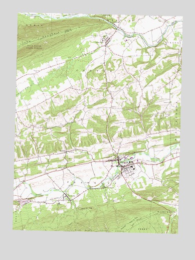
Middleburg, PA USGS Topographic Map
Click on map above to begin viewing in our Map Viewer.

This topographic map contains these locations and features:
Feature Name Type Latitude Longitude GNIS ID View Map
Berger SchoolSchoolN40.8209°W77.1103°1196936View Map
Block Ore RidgeRidgeN40.7631°W77.0658°1169826View Map
Borough of MiddleburgCivilN40.7893°W77.0446°1215577View Map
Boyer CemeteryCemeteryN40.8187°W77.0175°1196934View Map
Boyer ChurchChurchN40.8187°W77.0169°1170090View Map
Coon HunterPopulated PlaceN40.7759°W77.0550°1172410View Map
Dry RunStreamN40.8629°W77.0425°1173533View Map
Emmanuel CemeteryCemeteryN40.8634°W77.0522°1174226View Map
Erdly SchoolSchoolN40.7962°W77.0464°1196935View Map
Furnace TrailTrailN40.7581°W77.0766°1175368View Map
Gilbert SchoolSchoolN40.8070°W77.0216°1196928View Map
Glendale CemeteryCemeteryN40.7940°W77.0436°1175716View Map
Hartman SchoolSchoolN40.8276°W77.0736°1196932View Map
Hassinger SchoolSchoolN40.7859°W77.0878°1196933View Map
Hassingers ChurchChurchN40.7865°W77.0858°1176638View Map
Hazlett School (historical)SchoolN40.8562°W77.0003°1196930View Map
Herman SchoolSchoolN40.8415°W77.1069°1209045View Map
Hummel ChurchChurchN40.8254°W77.0083°1177583View Map
KissimmeePopulated PlaceN40.7954°W77.0853°1178557View Map
Limestone RidgeRidgeN40.7656°W77.1219°1179358View Map
MiddleburgPopulated PlaceN40.7859°W77.0472°1213636View Map
Middleburg Borough Police DepartmentBuildingN40.7929°W77.0464°2780501View Map
Middleburg Post officePost OfficeN40.7927°W77.0464°2772829View Map
Ocker School (historical)SchoolN40.8368°W77.0239°1196931View Map
PaxtonvillePopulated PlaceN40.7704°W77.0836°1183410View Map
Paxtonville Census Designated PlaceCensusN40.7702°W77.0808°2389650View Map
Paxtonville Post OfficePost OfficeN40.7716°W77.0861°2773233View Map
Penns CreekPopulated PlaceN40.8598°W77.0553°1183514View Map
Penns Creek AmbulanceBuildingN40.8574°W77.0588°2722291View Map
Penns Creek Census Designated PlaceCensusN40.8631°W77.0563°2389659View Map
Penns Creek Post OfficePost OfficeN40.8586°W77.0574°2780043View Map
Penns Creek Volunteer Fire CompanyBuildingN40.8574°W77.0588°2653236View Map
Port Ann ChurchChurchN40.8415°W77.1069°1200113View Map
Reliance Hose Company 1 Station 50BuildingN40.7878°W77.0423°2652730View Map
Renninger SchoolSchoolN40.7879°W77.0203°1196927View Map
Roadcap AirportAirportN40.7887°W77.1048°1194103View Map
Saint Lukes ChurchChurchN40.7962°W77.0830°1186298View Map
Saint Pauls CemeteryCemeteryN40.8537°W77.0558°1186565View Map
Salem ChurchChurchN40.8223°W77.0511°1186845View Map
Snyder CountyCivilN40.7698°W77.0702°1213686View Map
Snyder County Sheriff's OfficeBuildingN40.7914°W77.0461°2780482View Map
Summit ParkParkN40.7629°W77.0055°1197039View Map
Sweitzers RunStreamN40.8701°W77.0097°1189177View Map
Township of CenterCivilN40.8384°W77.0748°1217029View Map
Township of FranklinCivilN40.7812°W77.0657°1217031View Map
Tuscarora CreekStreamN40.8720°W77.0039°1189981View Map
WildwoodPopulated PlaceN40.8698°W77.0505°1191427View Map
Zion ChurchChurchN40.8101°W77.1105°1192002View Map

Note: Coordinates in the location and feature list above are referenced to NAD83 datum.


Copyright (C) 2008-2024 Ryan Niemi / Sunset Dynamics ... All Rights Reserved