TopoQuest Logo
Do you find TopoQuest useful?
Help keep TopoQuest running and adding new maps/features by donating!
Bitcoin:  19c7KJd3qBynnjoSw5npx9KScwjBe4ifkT
Litecoin:  LXs6TkuXGGXo1vDsWCkWVdjQX94eUKd6ui
Home View Maps Find Maps Find Places Resources & Links


Dalmatia, Pennsylvania Topographic Map

USGS Map Title: Dalmatia, PA
USGS Map MRC: 40076F8
DRG (GeoTIFF) Download: o40076f8.tif


Neighboring USGS Topographic Map Quads:


  Middleburg, PA  
40077G1
 

  Freeburg, PA  
40076G8
 

  Sunbury, PA  
40076G7
 

  Richfield, PA  
40077F1
 

  Dalmatia, PA  
40076F8
 

  Pillow, PA  
40076F7
 

  Reward, PA  
40077E1
 

  Millersburg, PA  
40076E8
 

  Elizabethville, PA  
40076E7


Map MRC Location:

N41°
W77°
N41°
W76°
H8 H7 H6 H5 H4 H3 H2 H1
G8 G7 G6 G5 G4 G3 G2 G1
F8 F7 F6 F5 F4 F3 F2 F1
E8 E7 E6 E5 E4 E3 E2 E1
D8 D7 D6 D5 D4 D3 D2 D1
C8 C7 C6 C5 C4 C3 C2 C1
B8 B7 B6 B5 B4 B3 B2 B1
A8 A7 A6 A5 A4 A3 A2 A1
N40°
W77°
N40°
W76°

Dalmatia, PA USGS 1:24K Topographic Map Preview:
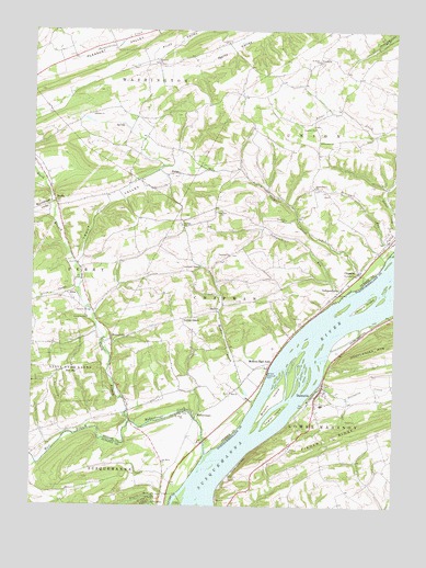
Dalmatia, PA USGS Topographic Map
Click on map above to begin viewing in our Map Viewer.

This topographic map contains these locations and features:
Feature Name Type Latitude Longitude GNIS ID View Map
AlinePopulated PlaceN40.6806°W76.9872°1202964View Map
Aline CreekStreamN40.6818°W76.9839°1168153View Map
Arnold SchoolSchoolN40.6843°W76.9147°1197167View Map
Bethel ChurchChurchN40.7276°W76.9791°1169395View Map
Browns IslandIslandN40.6529°W76.9164°1170391View Map
Buckwheat ValleyValleyN40.7022°W76.9938°1170590View Map
Ceejay Airport (historical)AirportN40.6940°W76.9328°1194066View Map
ChapmanPopulated PlaceN40.6873°W76.8866°1171568View Map
Chapman ChurchChurchN40.7026°W76.9339°1171571View Map
Chapman CreekStreamN40.6843°W76.8844°1171572View Map
DalmatiaPopulated PlaceN40.6543°W76.9025°1172899View Map
Dalmatia Census Designated PlaceCensusN40.6501°W76.9025°2634212View Map
Dalmatia CreekStreamN40.6568°W76.9005°1172900View Map
Dalmatia Post OfficePost OfficeN40.6518°W76.9014°2772662View Map
Dobson RunStreamN40.6362°W76.9978°1173323View Map
Ebenezer ChurchChurchN40.7409°W76.9566°1173954View Map
Grubbs ChurchChurchN40.6993°W76.9483°1176291View Map
Hall ChurchChurchN40.6548°W76.9308°1176393View Map
Herrold IslandIslandN40.6781°W76.8844°1176888View Map
HofferPopulated PlaceN40.6762°W76.9353°1177158View Map
Hoffer CreekStreamN40.6520°W76.9230°1177159View Map
Houtz SchoolSchoolN40.6898°W76.9447°1197168View Map
IndependencePopulated PlaceN40.6809°W76.8950°1177720View Map
Independence RunStreamN40.6804°W76.8922°1177726View Map
Locust GrovePopulated PlaceN40.6745°W76.9472°1179774View Map
Lower Mahanoy Fire Company Station 62BuildingN40.6532°W76.8996°2652860View Map
MahantangoPopulated PlaceN40.6490°W76.9425°1204085View Map
McKees Half FallsPopulated PlaceN40.6615°W76.9180°1180742View Map
MeiservillePopulated PlaceN40.6693°W76.9722°1180874View Map
North Branch Mahantango CreekStreamN40.6473°W76.9655°1193035View Map
PallasPopulated PlaceN40.7123°W76.9533°1204352View Map
Paradise ChurchChurchN40.6909°W76.9314°1199275View Map
Port Trevorton Census Designated PlaceCensusN40.6928°W76.8940°2389699View Map
Saint Johns ChurchChurchN40.6862°W76.8875°1186132View Map
Saint Pauls ChurchChurchN40.6490°W76.9475°1186609View Map
Saint Pauls ChurchChurchN40.7420°W76.9011°1186615View Map
ShadlePopulated PlaceN40.7059°W76.9922°1204619View Map
State Game Lands Number 194ParkN40.6584°W76.9841°1188479View Map
Stauffer ChurchChurchN40.7245°W76.9022°1188567View Map
Susquehanna ChurchChurchN40.7090°W76.9025°1189111View Map
The Bible ChurchChurchN40.6368°W76.9539°1189390View Map
Township of ChapmanCivilN40.6787°W76.9349°1217030View Map
Township of Lower MahanoyCivilN40.6486°W76.8770°1216922View Map
Township of UnionCivilN40.7267°W76.8900°1217038View Map
Trout ValleyValleyN40.6901°W76.9831°1199697View Map
TroutwellPopulated PlaceN40.6873°W76.9825°1197166View Map
VerdillaPopulated PlaceN40.7434°W76.9005°1204871View Map
West Branch Mahantango CreekStreamN40.6390°W76.9391°1190915View Map
Zeigler IslandIslandN40.6490°W76.9158°1191941View Map

Note: Coordinates in the location and feature list above are referenced to NAD83 datum.


Copyright (C) 2008-2024 Ryan Niemi / Sunset Dynamics ... All Rights Reserved