TopoQuest Logo
Do you find TopoQuest useful?
Help keep TopoQuest running and adding new maps/features by donating!
Bitcoin:  19c7KJd3qBynnjoSw5npx9KScwjBe4ifkT
Litecoin:  LXs6TkuXGGXo1vDsWCkWVdjQX94eUKd6ui
Home View Maps Find Maps Find Places Resources & Links


Salisbury, New York Topographic Map

USGS Map Title: Salisbury, NY
USGS Map MRC: 43074B7
DRG (GeoTIFF) Download: o43074b7.tif


Neighboring USGS Topographic Map Quads:


  Middleville, NY  
43074B8
 

  Salisbury, NY  
43074B7
 

  Stratford, NY  
43074B6
 

  Herkimer, NY  
43074A8
 

  Little Falls, NY  
43074A7
 

  Oppenheim, NY  
43074A6


Map MRC Location:

N44°
W75°
N44°
W74°
H8 H7 H6 H5 H4 H3 H2 H1
G8 G7 G6 G5 G4 G3 G2 G1
F8 F7 F6 F5 F4 F3 F2 F1
E8 E7 E6 E5 E4 E3 E2 E1
D8 D7 D6 D5 D4 D3 D2 D1
C8 C7 C6 C5 C4 C3 C2 C1
B8 B7 B6 B5 B4 B3 B2 B1
A8 A7 A6 A5 A4 A3 A2 A1
N43°
W75°
N43°
W74°

Salisbury, NY USGS 1:24K Topographic Map Preview:
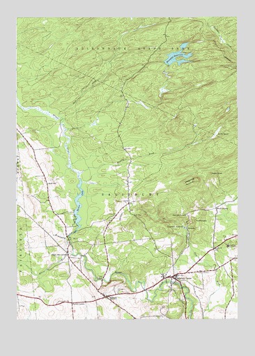
Salisbury, NY USGS Topographic Map
Click on map above to begin viewing in our Map Viewer.

This topographic map contains these locations and features:
Feature Name Type Latitude Longitude GNIS ID View Map
Beaver CreekStreamN43.1517°W74.8429°943376View Map
Boardinghouse ClearingFlatN43.1797°W74.7942°2123441View Map
Buck CreekStreamN43.2078°W74.8510°945018View Map
Burrell CornersLocaleN43.1317°W74.8432°945282View Map
Comstock CemeteryCemeteryN43.1844°W74.8593°947247View Map
CurtisPopulated PlaceN43.1731°W74.8110°947949View Map
Curtis CemeteryCemeteryN43.1685°W74.8184°947952View Map
Diamond HillSummitN43.1606°W74.8374°948409View Map
Dolgeville ReservoirReservoirN43.1631°W74.7802°948552View Map
Fairview CemeteryCemeteryN43.1369°W74.7883°952867View Map
Fairview CornersLocaleN43.1681°W74.7782°949850View Map
Hedgehog MountainSummitN43.1826°W74.7738°952521View Map
Holsted CemeteryCemeteryN43.1262°W74.7964°953026View Map
IrondalePopulated PlaceN43.1626°W74.7785°972657View Map
Ives HollowPopulated PlaceN43.1423°W74.8254°953862View Map
Kelly SchoolSchoolN43.1812°W74.8571°954478View Map
Kettle BeaverSwampN43.2015°W74.7618°954563View Map
Kirby Free Library of SalisburyBuildingN43.1429°W74.7869°2598801View Map
Klondike ReservoirReservoirN43.2309°W74.7829°954753View Map
Mexico ClearingFlatN43.2028°W74.8492°2123442View Map
Murphy BrookStreamN43.1853°W74.8396°958181View Map
Murphy ClearingFlatN43.1931°W74.8106°2123443View Map
Paper Mill CornersPopulated PlaceN43.1523°W74.8454°959838View Map
Peck CemeteryCemeteryN43.1664°W74.7623°960076View Map
Pine Crest SanatoriumHospitalN43.1553°W74.7551°960439View Map
Poplar KnollSummitN43.1853°W74.7652°960938View Map
Saint Bridget CemeteryCemeteryN43.1359°W74.8175°963393View Map
SalisburyPopulated PlaceN43.1342°W74.8240°964303View Map
Salisbury CemeteryCemeteryN43.1364°W74.8130°2556848View Map
Salisbury CenterPopulated PlaceN43.1426°W74.7865°964304View Map
Salisbury Center BridgeBridgeN43.1406°W74.7877°2419915View Map
Salisbury Center Post OfficePost OfficeN43.1442°W74.7813°2598761View Map
Salisbury Volunteer Fire Department Station 1BuildingN43.1433°W74.7881°2735075View Map
Salisbury Volunteer Fire Department Station 2BuildingN43.1347°W74.8241°2735076View Map
School Number 1 (historical)SchoolN43.1528°W74.8461°2123444View Map
Spruce LakeReservoirN43.1726°W74.8397°966129View Map
The PinnacleSummitN43.1656°W74.7738°967312View Map
Town of SalisburyCivilN43.2156°W74.7937°979454View Map
Tuttle CemeteryCemeteryN43.1443°W74.7711°968008View Map
Wood CornersLocaleN43.1709°W74.7618°971596View Map

Note: Coordinates in the location and feature list above are referenced to NAD83 datum.


Copyright (C) 2008-2024 Ryan Niemi / Sunset Dynamics ... All Rights Reserved