TopoQuest Logo
Do you find TopoQuest useful?
Help keep TopoQuest running and adding new maps/features by donating!
Bitcoin:  19c7KJd3qBynnjoSw5npx9KScwjBe4ifkT
Litecoin:  LXs6TkuXGGXo1vDsWCkWVdjQX94eUKd6ui
Home View Maps Find Maps Find Places Resources & Links


Midway, South Carolina Topographic Map

USGS Map Title: Midway, SC
USGS Map MRC: 33080C8
DRG (GeoTIFF) Download: o33080c8.tif


Neighboring USGS Topographic Map Quads:


  Norway East, SC  
33081D1
 

  Cordova, SC  
33080D8
 

  Orangeburg South, SC  
33080D7
 

  Bamberg, SC  
33081C1
 

  Midway, SC  
33080C8
 

  Branchville North, SC  
33080C7
 

  Clear Pond, SC  
33081B1
 

  Tony Hill Bay, SC  
33080B8
 

  Branchville South, SC  
33080B7


Map MRC Location:

N34°
W81°
N34°
W80°
H8 H7 H6 H5 H4 H3 H2 H1
G8 G7 G6 G5 G4 G3 G2 G1
F8 F7 F6 F5 F4 F3 F2 F1
E8 E7 E6 E5 E4 E3 E2 E1
D8 D7 D6 D5 D4 D3 D2 D1
C8 C7 C6 C5 C4 C3 C2 C1
B8 B7 B6 B5 B4 B3 B2 B1
A8 A7 A6 A5 A4 A3 A2 A1
N33°
W81°
N33°
W80°

Midway, SC USGS 1:24K Topographic Map Preview:
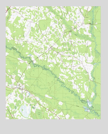
Midway, SC USGS Topographic Map
Click on map above to begin viewing in our Map Viewer.

This topographic map contains these locations and features:
Feature Name Type Latitude Longitude GNIS ID View Map
Bethel ChurchChurchN33.3202°W80.9165°1220553View Map
Bethlehem CemeteryCemeteryN33.3469°W80.9161°1220594View Map
Bethlehem Church (historical)ChurchN33.3471°W80.9168°1242518View Map
Cana of Galilee ChurchChurchN33.3274°W80.9398°1221288View Map
CanaanPopulated PlaceN33.3288°W80.9409°1221289View Map
Canaan CemeteryCemeteryN33.3302°W80.9401°1242552View Map
Canaan ChurchChurchN33.3299°W80.9409°1221293View Map
Canaan Fire Department Station 1BuildingN33.3327°W80.9371°2368416View Map
Canaan Fire Department Station 2BuildingN33.3501°W80.9098°2368076View Map
Canaan School (historical)SchoolN33.3321°W80.9376°1242557View Map
Cannon BridgeBridgeN33.3140°W80.9654°1247147View Map
Cedar Grove ChurchChurchN33.3507°W80.9084°1221452View Map
Cedar Grove School (historical)SchoolN33.3510°W80.9084°1242563View Map
Cooper SwampStreamN33.3363°W80.8834°1221743View Map
Cope DivisionCivilN33.3690°W80.9628°1938237View Map
Corner School (historical)SchoolN33.3274°W80.9098°1242584View Map
Dry SwampStreamN33.3607°W80.8879°1222119View Map
Edisto School (historical)SchoolN33.2996°W80.8995°1242603View Map
Emanuel CemeteryCemeteryN33.3235°W80.9295°1242610View Map
Emanuel ChurchChurchN33.3238°W80.9304°1247665View Map
Emanuel School (historical)SchoolN33.3238°W80.9307°1242611View Map
EmbreePopulated PlaceN33.2579°W80.8920°1247666View Map
Fork Bridges (historical)BridgeN33.2804°W80.8812°1242628View Map
Gannts BaySwampN33.2779°W80.9984°1222634View Map
Isaac Jennings CanalCanalN33.3452°W80.9757°1223464View Map
McMillan School (historical)SchoolN33.3002°W80.8918°1242693View Map
MidwayPopulated PlaceN33.2835°W80.9782°1224480View Map
Mount Pisgah Church (historical)ChurchN33.3368°W80.9801°1242716View Map
Mount Pisgah School (historical)SchoolN33.3588°W80.9657°1242718View Map
Mount Zion ChurchChurchN33.2796°W80.9779°1249705View Map
North Fork Edisto RiverStreamN33.2643°W80.8870°1225079View Map
Oakland CemeteryCemeteryN33.3721°W80.9845°1225143View Map
Pilgrim Baptist ChurchChurchN33.2865°W80.9801°1250086View Map
Rowesville BridgeBridgeN33.3552°W80.8870°1226058View Map
South Fork Edisto RiverStreamN33.2640°W80.8870°1226760View Map
Tatums Pond Dam D-2823DamN33.2768°W80.9682°1239677View Map

Note: Coordinates in the location and feature list above are referenced to NAD83 datum.


Copyright (C) 2008-2024 Ryan Niemi / Sunset Dynamics ... All Rights Reserved