TopoQuest Logo
Do you find TopoQuest useful?
Help keep TopoQuest running and adding new maps/features by donating!
Bitcoin:  19c7KJd3qBynnjoSw5npx9KScwjBe4ifkT
Litecoin:  LXs6TkuXGGXo1vDsWCkWVdjQX94eUKd6ui
Home View Maps Find Maps Find Places Resources & Links


Branchville South, South Carolina Topographic Map

USGS Map Title: Branchville South, SC
USGS Map MRC: 33080B7
DRG (GeoTIFF) Download: o33080b7.tif


Neighboring USGS Topographic Map Quads:


  Midway, SC  
33080C8
 

  Branchville North, SC  
33080C7
 

  Bowman, SC  
33080C6
 

  Tony Hill Bay, SC  
33080B8
 

  Branchville South, SC  
33080B7
 

  Reevesville, SC  
33080B6
 

  Lodge, SC  
33080A8
 

  Williams, SC  
33080A7
 

  Saint George SW, SC  
33080A6


Map MRC Location:

N34°
W81°
N34°
W80°
H8 H7 H6 H5 H4 H3 H2 H1
G8 G7 G6 G5 G4 G3 G2 G1
F8 F7 F6 F5 F4 F3 F2 F1
E8 E7 E6 E5 E4 E3 E2 E1
D8 D7 D6 D5 D4 D3 D2 D1
C8 C7 C6 C5 C4 C3 C2 C1
B8 B7 B6 B5 B4 B3 B2 B1
A8 A7 A6 A5 A4 A3 A2 A1
N33°
W81°
N33°
W80°

Branchville South, SC USGS 1:24K Topographic Map Preview:
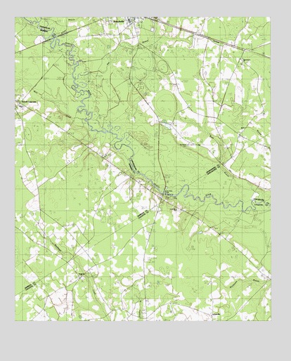
Branchville South, SC USGS Topographic Map
Click on map above to begin viewing in our Map Viewer.

This topographic map contains these locations and features:
Feature Name Type Latitude Longitude GNIS ID View Map
Betty BranchStreamN33.2499°W80.8615°1220630View Map
Branchville Fire DepartmentBuildingN33.2482°W80.8195°2368317View Map
Branchville Fire Department McAlhany StationBuildingN33.2014°W80.7649°2368480View Map
Branchville High SchoolSchoolN33.2464°W80.7902°1242530View Map
Branchville Police DepartmentBuildingN33.2489°W80.8167°2334922View Map
Branchville Rescue SquadBuildingN33.2482°W80.8195°2368310View Map
Brier CreekStreamN33.2088°W80.8393°1246985View Map
Buckhead CemeteryCemeteryN33.1440°W80.8434°1240571View Map
Buckhead ChurchChurchN33.1438°W80.8432°1240572View Map
Buckhead School (historical)SchoolN33.1707°W80.8629°1247043View Map
Bush BranchStreamN33.1746°W80.7534°1241057View Map
Dukes Pond Dam D-3779DamN33.2035°W80.7998°1240354View Map
Edisto Baptist ChurchChurchN33.2135°W80.8709°1230906View Map
Edisto Fire Department Station 9BuildingN33.2119°W80.8658°2368414View Map
Farrell CrossroadsPopulated PlaceN33.2140°W80.8734°1253471View Map
Fifty Eight (historical)Populated PlaceN33.2349°W80.7554°1242619View Map
Fitts BridgeBridgeN33.2388°W80.8482°1222415View Map
Hopewell SchoolSchoolN33.1829°W80.8643°1223292View Map
JohnsvillePopulated PlaceN33.1277°W80.7790°1240660View Map
Lockett Elementary SchoolSchoolN33.2463°W80.7891°2486434View Map
Lovely Hill ChurchChurchN33.1707°W80.7962°1240672View Map
Mack Branch Baptist ChurchChurchN33.2315°W80.7637°1242682View Map
Mack Branch School (historical)SchoolN33.2315°W80.7632°1242683View Map
May - Stokes - Raysor CemeteryCemeteryN33.1446°W80.7509°1240675View Map
May CemeteryCemeteryN33.1465°W80.8093°1240673View Map
McAlbany ChurchChurchN33.2193°W80.7776°1242691View Map
McAlhany CemeteryCemeteryN33.1972°W80.7904°1242692View Map
McBranch Baptist ChurchChurchN33.2315°W80.7635°2490333View Map
McIihenny SchoolSchoolN33.2093°W80.7779°1224408View Map
Pen BranchStreamN33.2288°W80.8393°1225356View Map
Piney Grove SchoolSchoolN33.1429°W80.8423°1225501View Map
Sandy Island BridgeBridgeN33.1782°W80.8018°1250771View Map
Sandy Run ChurchChurchN33.1852°W80.8445°1226386View Map
Sandy Run SchoolSchoolN33.1832°W80.8190°1226389View Map
Simmons Johnsville School (historical)SchoolN33.1277°W80.7798°1240741View Map
Spell - Risher CemeteryCemeteryN33.1449°W80.7506°1240752View Map
Whetstone CrossroadsPopulated PlaceN33.1754°W80.8034°1230991View Map

Note: Coordinates in the location and feature list above are referenced to NAD83 datum.


Copyright (C) 2008-2025 Ryan Niemi / Sunset Dynamics ... All Rights Reserved