TopoQuest Logo
Do you find TopoQuest useful?
Help keep TopoQuest running and adding new maps/features by donating!
Bitcoin:  19c7KJd3qBynnjoSw5npx9KScwjBe4ifkT
Litecoin:  LXs6TkuXGGXo1vDsWCkWVdjQX94eUKd6ui
Home View Maps Find Maps Find Places Resources & Links


Miles Pond, Vermont Topographic Map

USGS Map Title: Miles Pond, VT
USGS Map MRC: 44071D7
DRG (GeoTIFF) Download: o44071d7.tif


Neighboring USGS Topographic Map Quads:


  Burke Mountain, VT  
44071E8
 

  Gallup Mills, VT  
44071E7
 

  Stone Mountain, VT  
44071E6
 

  Concord, VT  
44071D8
 

  Miles Pond, VT  
44071D7


  Lower Waterford, VT  
44071C8
 

  Littleton, NH  
44071C7


Map MRC Location:

N45°
W72°
N45°
W71°
H8 H7 H6 H5 H4 H3 H2 H1
G8 G7 G6 G5 G4 G3 G2 G1
F8 F7 F6 F5 F4 F3 F2 F1
E8 E7 E6 E5 E4 E3 E2 E1
D8 D7 D6 D5 D4 D3 D2 D1
C8 C7 C6 C5 C4 C3 C2 C1
B8 B7 B6 B5 B4 B3 B2 B1
A8 A7 A6 A5 A4 A3 A2 A1
N44°
W72°
N44°
W71°

Miles Pond, VT USGS 1:24K Topographic Map Preview:
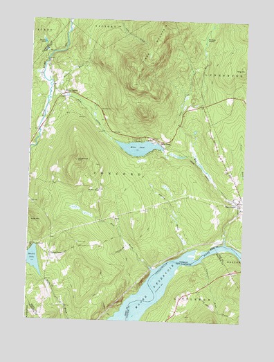
Miles Pond, VT USGS Topographic Map
Click on map above to begin viewing in our Map Viewer.

This topographic map contains these locations and features:
Feature Name Type Latitude Longitude GNIS ID View Map
Brook School (historical)SchoolN44.3814°W71.8523°1919302View Map
Carpenter BrookStreamN44.4001°W71.7726°866003View Map
Carr BrookStreamN44.4439°W71.7787°1456775View Map
Concord CornerPopulated PlaceN44.4014°W71.8615°1456993View Map
Cutting BrookStreamN44.4070°W71.8162°1457083View Map
Dudley BrookStreamN44.4701°W71.8631°1457208View Map
East ConcordPopulated PlaceN44.4248°W71.7537°1457270View Map
Frye CemeteryCemeteryN44.4001°W71.8613°1919336View Map
Goudreault HillSummitN44.4417°W71.8470°1457583View Map
Graves CemeteryCemeteryN44.4075°W71.8459°1457615View Map
Hastings SwampSwampN44.4921°W71.7738°1457758View Map
Johnson PondLakeN44.4911°W71.8674°1458025View Map
King HillSummitN44.4803°W71.7512°1458093View Map
Miles MountainSummitN44.4806°W71.8120°1458449View Map
Miles PondReservoirN44.4471°W71.8113°1458450View Map
Miles PondPopulated PlaceN44.4473°W71.7965°1458451View Map
Miles Pond DamDamN44.4467°W71.8115°1766403View Map
Miles StreamStreamN44.4078°W71.7601°1458452View Map
Mink BrookStreamN44.3962°W71.8020°1458494View Map
Nichols Hall (historical)BuildingN44.4589°W71.7665°1919375View Map
North ConcordPopulated PlaceN44.4684°W71.8554°1458722View Map
North Concord CemeteryCemeteryN44.4770°W71.8682°1919376View Map
North Concord Post OfficePost OfficeN44.4693°W71.8589°1919377View Map
North Concord School (historical)SchoolN44.4801°W71.8631°1919378View Map
Old Overlook CemeteryCemeteryN44.4084°W71.7606°1919385View Map
Overlook CemeteryCemeteryN44.4083°W71.7609°1458863View Map
Ralston CornerPopulated PlaceN44.4292°W71.8337°1459135View Map
Ralston Corner School (historical)SchoolN44.4298°W71.8337°1919390View Map
Roaring BrookStreamN44.4048°W71.7818°1459212View Map
Royalston Corner CemeteryCemeteryN44.4396°W71.8341°1919397View Map
Samuel Reed Hall MonumentParkN44.4028°W71.8609°1919401View Map
Shadow LakeLakeN44.4002°W71.8714°1459452View Map
Shaw MountainSummitN44.4164°W71.8734°1459469View Map
TexasPopulated PlaceN44.4178°W71.8245°1460463View Map
Texas School (historical)SchoolN44.4153°W71.8231°1919412View Map
Town of ConcordCivilN44.4315°W71.8337°1462074View Map

Note: Coordinates in the location and feature list above are referenced to NAD83 datum.


Copyright (C) 2008-2024 Ryan Niemi / Sunset Dynamics ... All Rights Reserved