TopoQuest Logo
Do you find TopoQuest useful?
Help keep TopoQuest running and adding new maps/features by donating!
Bitcoin:  19c7KJd3qBynnjoSw5npx9KScwjBe4ifkT
Litecoin:  LXs6TkuXGGXo1vDsWCkWVdjQX94eUKd6ui
Home View Maps Find Maps Find Places Resources & Links


Milford, Utah Topographic Map

USGS Map Title: Milford, UT
USGS Map MRC: 38113D1
DRG (GeoTIFF) Download: o38113d1.tif


Neighboring USGS Topographic Map Quads:


  High Rock, UT  
38113E2
 

  Lime Mountain, UT  
38113E1
 

  Read, UT  
38112E8
 

  Milford NW, UT  
38113D2
 

  Milford, UT  
38113D1
 

  Ranch Canyon, UT  
38112D8
 

  Picacho Peak, UT  
38113C2
 

  Milford Flat, UT  
38113C1
 

  Cave Canyon, UT  
38112C8


Map MRC Location:

N39°
W114°
N39°
W113°
H8 H7 H6 H5 H4 H3 H2 H1
G8 G7 G6 G5 G4 G3 G2 G1
F8 F7 F6 F5 F4 F3 F2 F1
E8 E7 E6 E5 E4 E3 E2 E1
D8 D7 D6 D5 D4 D3 D2 D1
C8 C7 C6 C5 C4 C3 C2 C1
B8 B7 B6 B5 B4 B3 B2 B1
A8 A7 A6 A5 A4 A3 A2 A1
N38°
W114°
N38°
W113°

Milford, UT USGS 1:24K Topographic Map Preview:
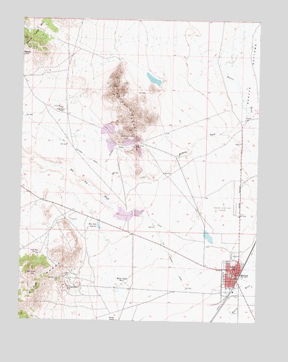
Milford, UT USGS Topographic Map
Click on map above to begin viewing in our Map Viewer.

This topographic map contains these locations and features:
Feature Name Type Latitude Longitude GNIS ID View Map
Beaver County Fire District - MilfordBuildingN38.3952°W113.0108°2627443View Map
Beaver County Sheriff's Office MilfordBuildingN38.3969°W113.0123°2730444View Map
Beaver-Harrison MineMineN38.4869°W113.1208°1425390View Map
Big Wash DamDamN38.4100°W113.0925°1434683View Map
Big Wash ReservoirReservoirN38.4100°W113.0925°1434684View Map
City of MilfordCivilN38.3945°W113.0123°2411106View Map
Copper King MineMineN38.4022°W113.1169°1426856View Map
Copper Ranch MineMineN38.4616°W113.1061°1426861View Map
First Baptist ChurchChurchN38.3961°W113.0097°1435530View Map
Harrington-Hickory MineMineN38.3891°W113.1000°1428544View Map
Hickory WashValleyN38.4586°W113.0086°1428686View Map
Little May Lilly MineMineN38.3922°W113.1050°1429758View Map
Lower Big Wash DamDamN38.4194°W113.0619°1434686View Map
Lower Big Wash ReservoirReservoirN38.4201°W113.0638°1434685View Map
MilfordPopulated PlaceN38.3969°W113.0108°1430317View Map
Milford Catholic ChurchChurchN38.3952°W113.0125°1435949View Map
Milford City CemeteryCemeteryN38.3950°W113.0149°1435950View Map
Milford Community Methodist ChurchChurchN38.4005°W113.0113°1436742View Map
Milford Elementary SchoolSchoolN38.3941°W113.0198°1435952View Map
Milford High SchoolSchoolN38.3979°W113.0135°1435951View Map
Milford Municipal Airport/Ben and Judy Briscoe FieldAirportN38.4234°W113.0133°1434563View Map
Milford Post OfficePost OfficeN38.3932°W113.0118°1455393View Map
Milford Valley Memorial HospitalHospitalN38.4071°W113.0090°1435953View Map
Mollies Nipple WellWellN38.3914°W113.0702°1430408View Map
Montreal MineMineN38.4525°W113.0727°1430440View Map
Old Hickory MineMineN38.4472°W113.0650°1430977View Map
Rebel MineMineN38.3941°W113.1019°1431605View Map
Rocky RangeRangeN38.4616°W113.0688°1431973View Map
The Big WashValleyN38.4186°W113.0597°1433269View Map
The Church of Jesus Christ of Latter Day SaintsChurchN38.3969°W113.0125°1436999View Map
West Point ReservoirReservoirN38.4137°W113.0841°1434110View Map

Note: Coordinates in the location and feature list above are referenced to NAD83 datum.


Copyright (C) 2008-2025 Ryan Niemi / Sunset Dynamics ... All Rights Reserved