TopoQuest Logo
Do you find TopoQuest useful?
Help keep TopoQuest running and adding new maps/features by donating!
Bitcoin:  19c7KJd3qBynnjoSw5npx9KScwjBe4ifkT
Litecoin:  LXs6TkuXGGXo1vDsWCkWVdjQX94eUKd6ui
Home View Maps Find Maps Find Places Resources & Links


West Winfield, New York Topographic Map

USGS Map Title: West Winfield, NY
USGS Map MRC: 42075H2
DRG (GeoTIFF) Download: o42075h2.tif


Neighboring USGS Topographic Map Quads:


  Utica West, NY  
43075A3
 

  Utica East, NY  
43075A2
 

  Ilion, NY  
43075A1
 

  Cassville, NY  
42075H3
 

  West Winfield, NY  
42075H2
 

  Millers Mills, NY  
42075H1
 

  Brookfield, NY  
42075G3
 

  Unadilla Forks, NY  
42075G2
 

  Schuyler Lake, NY  
42075G1


Map MRC Location:

N43°
W76°
N43°
W75°
H8 H7 H6 H5 H4 H3 H2 H1
G8 G7 G6 G5 G4 G3 G2 G1
F8 F7 F6 F5 F4 F3 F2 F1
E8 E7 E6 E5 E4 E3 E2 E1
D8 D7 D6 D5 D4 D3 D2 D1
C8 C7 C6 C5 C4 C3 C2 C1
B8 B7 B6 B5 B4 B3 B2 B1
A8 A7 A6 A5 A4 A3 A2 A1
N42°
W76°
N42°
W75°

West Winfield, NY USGS 1:24K Topographic Map Preview:
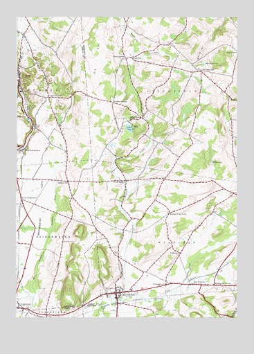
West Winfield, NY USGS Topographic Map
Click on map above to begin viewing in our Map Viewer.

This topographic map contains these locations and features:
Feature Name Type Latitude Longitude GNIS ID View Map
Babcock HillPopulated PlaceN42.9317°W75.2207°942749View Map
Babcock Hill CemeteryCemeteryN42.9323°W75.1881°2513729View Map
Bardin CemeteryCemeteryN42.9012°W75.1927°942995View Map
Birmingham CornersPopulated PlaceN42.8887°W75.1377°944033View Map
Bridgewater CemeteryCemeteryN42.9067°W75.2232°944732View Map
Bridgewater FlatsFlatN42.9251°W75.2354°944733View Map
Bridgewater Free LibraryBuildingN42.8838°W75.2496°2617231View Map
Cedar LakeLakeN42.9538°W75.1861°946120View Map
Cedar LakePopulated PlaceN42.9581°W75.1793°946121View Map
Cedar Lake CemeteryCemeteryN42.9641°W75.1939°2556880View Map
Cedar Lake ClubLocaleN42.9561°W75.1904°2598788View Map
Clayville Fire DepartmentBuildingN42.9771°W75.2489°2718385View Map
Clayville Post OfficePost OfficeN42.9769°W75.2482°2780780View Map
Days CornersPopulated PlaceN42.9828°W75.1885°948089View Map
Dry HillSummitN42.9890°W75.2029°948695View Map
East WinfieldPopulated PlaceN42.8887°W75.1452°949280View Map
East Winfield CemeteryCemeteryN42.8869°W75.1525°2556877View Map
Fairview CemeteryCemeteryN42.9051°W75.2441°949834View Map
Faith ChapelChurchN42.8793°W75.2497°2615907View Map
Faith Christian SchoolSchoolN42.8788°W75.2494°2669018View Map
Gird CemeteryCemeteryN42.9578°W75.1890°951145View Map
Goodiers CornersLocaleN42.9645°W75.1954°951327View Map
Hitching CornerPopulated PlaceN42.8887°W75.1649°952901View Map
Jersalem HillPopulated PlaceN42.9776°W75.1460°972664View Map
Jerusalem Hill CemeteryCemeteryN42.9774°W75.1507°2556882View Map
Kibby PondLakeN42.9395°W75.1391°954591View Map
Ludlow CornersLocaleN42.9667°W75.2318°956141View Map
Meeting House GreenLocaleN42.9184°W75.1632°956917View Map
Meeting House Green CemeteryCemeteryN42.9186°W75.1636°2556878View Map
Mount Markham Elementary SchoolSchoolN42.8890°W75.1808°2597752View Map
Mount Markham Middle SchoolSchoolN42.8867°W75.1842°2597758View Map
Mount Markham Senior High SchoolSchoolN42.8907°W75.1841°2597762View Map
North BridgewaterPopulated PlaceN42.9242°W75.2468°958731View Map
North WinfieldPopulated PlaceN42.9320°W75.1879°958949View Map
North Winfield CreekStreamN42.8817°W75.1916°958950View Map
Oertle Field (historical)AirportN42.9167°W75.2324°977920View Map
Pine Village EstatesPopulated PlaceN42.9319°W75.2417°2485846View Map
Ritchfield JunctionPopulated PlaceN42.9451°W75.2460°973006View Map
Saint Joseph's CemeteryCemeteryN42.8870°W75.1988°963728View Map
Saint Joseph's ChurchChurchN42.8851°W75.1988°2597781View Map
Saint Mary's CemeteryCemeteryN42.9845°W75.2484°963906View Map
Sauquoit Knolls Golf ClubLocaleN42.9970°W75.2350°2615475View Map
Sauquoit ValleyValleyN42.9951°W75.2460°964509View Map
Sauquoit Valley CemeteryCemeteryN42.9867°W75.2457°964510View Map
School Number 5 (historical)SchoolN42.9831°W75.1854°975430View Map
School Number 6 (historical)SchoolN42.9189°W75.1633°2376999View Map
School Number 7 (historical)SchoolN42.9017°W75.1571°975549View Map
The Federated ChurchChurchN42.8851°W75.1897°2598298View Map
Town of LitchfieldCivilN42.9735°W75.1544°979156View Map
Town of WinfieldCivilN42.8983°W75.1634°979650View Map
Village of ClayvilleCivilN42.9748°W75.2490°2391610View Map
Village of West WinfieldCivilN42.8838°W75.1914°2391211View Map
West WinfieldPopulated PlaceN42.8853°W75.1932°970891View Map
West Winfield CemeteryCemeteryN42.8833°W75.1967°2556875View Map
West Winfield Post OfficePost OfficeN42.8849°W75.1944°2598762View Map
West Winfield Volunteer Fire Department Henry Hiteman Engine and Hose CompanyBuildingN42.8854°W75.1947°2734769View Map
Wheelock HillSummitN42.9851°W75.1454°971024View Map
Wheelock PondLakeN42.9809°W75.1442°971025View Map

Note: Coordinates in the location and feature list above are referenced to NAD83 datum.


Copyright (C) 2008-2024 Ryan Niemi / Sunset Dynamics ... All Rights Reserved