TopoQuest Logo
Do you find TopoQuest useful?
Help keep TopoQuest running and adding new maps/features by donating!
Bitcoin:  19c7KJd3qBynnjoSw5npx9KScwjBe4ifkT
Litecoin:  LXs6TkuXGGXo1vDsWCkWVdjQX94eUKd6ui
Home View Maps Find Maps Find Places Resources & Links


Milton, Louisiana Topographic Map

USGS Map Title: Milton, LA
USGS Map MRC: 30092A1
DRG (GeoTIFF) Download: o30092a1.tif


Neighboring USGS Topographic Map Quads:


  Duson, LA  
30092B2
 

  Lafayette, LA  
30092B1
 

  Broussard, LA  
30091B8
 

  Leroy, LA  
30092A2
 

  Milton, LA  
30092A1
 

  Youngsville, LA  
30091A8
 

  Abbeville West, LA  
29092H2
 

  Abbeville East, LA  
29092H1
 

  Delcambre, LA  
29091H8


Map MRC Location:

N31°
W93°
N31°
W92°
H8 H7 H6 H5 H4 H3 H2 H1
G8 G7 G6 G5 G4 G3 G2 G1
F8 F7 F6 F5 F4 F3 F2 F1
E8 E7 E6 E5 E4 E3 E2 E1
D8 D7 D6 D5 D4 D3 D2 D1
C8 C7 C6 C5 C4 C3 C2 C1
B8 B7 B6 B5 B4 B3 B2 B1
A8 A7 A6 A5 A4 A3 A2 A1
N30°
W93°
N30°
W92°

Milton, LA USGS 1:24K Topographic Map Preview:
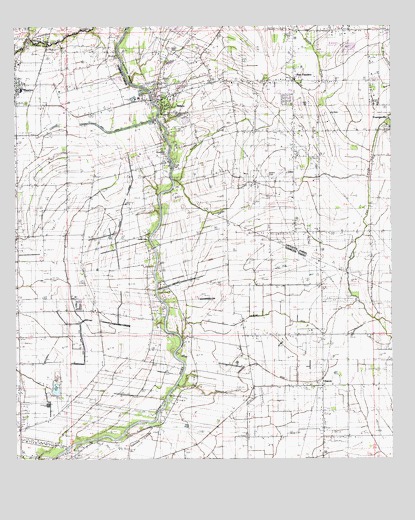
Milton, LA USGS Topographic Map
Click on map above to begin viewing in our Map Viewer.

This topographic map contains these locations and features:
Feature Name Type Latitude Longitude GNIS ID View Map
Amana Christian Fellowship ChurchChurchN30.1019°W92.1210°2600529View Map
Anselm CouleeStreamN30.0808°W92.0726°558134View Map
Anselm Coulee Gas FieldOilfieldN30.1071°W92.0348°557236View Map
Bodoin CemeteryCemeteryN30.0819°W92.0409°533257View Map
Broussard CemeteryCemeteryN30.0896°W92.0748°533428View Map
Broussard CemeteryCemeteryN30.1155°W92.0910°533429View Map
Camp SteenLocaleN30.0096°W92.0918°544179View Map
Cecil Picard Elementary School at MauriceSchoolN30.1072°W92.1229°544241View Map
Cedar Village Shopping CenterLocaleN30.1052°W92.0746°2600005View Map
CharonPopulated PlaceN30.0216°W92.0232°533884View Map
Darby CouleeStreamN30.0805°W92.0701°558204View Map
Ernest Gallet Elementary SchoolSchoolN30.1102°W92.0132°2493428View Map
First Assembly of God ChurchChurchN30.1171°W92.0302°2601719View Map
First Baptist Church of MiltonChurchN30.1097°W92.0594°2601783View Map
FlandersPopulated PlaceN30.0991°W92.0323°557296View Map
Fusilier Mobile Home EstatesPopulated PlaceN30.0793°W92.1208°2600403View Map
Gallet CemeteryCemeteryN30.0638°W92.0807°554502View Map
Granges CouleeStreamN30.1216°W92.1201°559681View Map
Greene Air ParkAirportN30.0347°W92.0560°2676778View Map
Grosse Isle Gas FieldOilfieldN30.0046°W92.0668°544314View Map
KROF-AM (Abbeville)TowerN30.0113°W92.1226°1633145View Map
KROF-FM (Abbeville)TowerN30.0113°W92.1226°1633028View Map
KROF-KDSC Radio TowerTowerN30.0124°W92.1226°551113View Map
Lafayette Parish Library Milton BranchBuildingN30.1052°W92.0746°2603094View Map
Lakeview Mobile Home ParkPopulated PlaceN30.0979°W92.0703°2600444View Map
Langlinais DitchCanalN30.0194°W92.0501°536331View Map
LeBlanc DitchCanalN30.0413°W92.0343°536376View Map
LeBlanc SchoolSchoolN30.0369°W92.0271°536377View Map
LeBlanc Volunteer Fire DepartmentBuildingN30.0361°W92.0376°2332414View Map
Long Pointe CouleyStreamN30.0213°W92.0715°558915View Map
Magnolia Plantation Water Treatment PlantLocaleN30.0027°W92.0701°2603380View Map
MauricePopulated PlaceN30.1085°W92.1246°536939View Map
Maurice Head Start SchoolSchoolN30.1145°W92.1181°2600240View Map
Maurice High School (historical)SchoolN30.1071°W92.1229°544243View Map
MiltonPopulated PlaceN30.1038°W92.0765°543474View Map
Milton Census Designated PlaceCensusN30.1138°W92.0704°2583542View Map
Milton Elementary SchoolSchoolN30.1052°W92.0769°557351View Map
Milton Gas FieldOilfieldN30.0905°W92.1168°544246View Map
Milton Post OfficePost OfficeN30.1037°W92.0762°1632132View Map
Milton Volunteer Fire DepartmentBuildingN30.1039°W92.0769°2691663View Map
Milton Volunteer Fire DepartmentBuildingN30.0945°W92.0530°2691827View Map
New FlandersPopulated PlaceN30.1094°W92.0326°537567View Map
North Parcperdue Gas FieldOilfieldN30.0627°W92.0501°544254View Map
Number Two Main CanalCanalN30.0402°W92.1018°537686View Map
Parcperdue Oil and Gas FieldOilfieldN30.0460°W92.0543°544259View Map
Parish Governing Authority District 1CivilN30.0674°W92.1142°1929765View Map
Parish Governing Authority District 3CivilN30.0188°W92.0234°1929982View Map
Picard CemeteryCemeteryN30.0844°W92.0721°538112View Map
Picard ParkParkN30.1185°W92.0723°557374View Map
Picard ParkParkN30.1188°W92.0721°551112View Map
Prejean CanalCanalN30.0291°W92.0887°538395View Map
Saint Josephs ChurchChurchN30.1045°W92.0732°2602676View Map
Saint Josephs ChurchChurchN30.1145°W92.1237°2602677View Map
Simon School (historical)SchoolN30.0949°W92.0321°557402View Map
Southside SchoolSchoolN30.0802°W92.1207°539523View Map
Steiner CanalCanalN30.0708°W92.0898°539653View Map
Sunrise Mobile Home ParkPopulated PlaceN30.0867°W92.0251°2600926View Map
Vermilion Parish Library Maurice BranchBuildingN30.1059°W92.1244°2603168View Map
Vermillion Court Mobile Home ParkPopulated PlaceN30.1094°W92.0057°2600953View Map
Village of MauriceCivilN30.1041°W92.1211°2407498View Map
West Parcperdue Oil and Gas FieldOilfieldN30.0496°W92.0912°544305View Map
WoodlawnPopulated PlaceN30.0621°W92.0771°544306View Map
Woodlawn BridgeBridgeN30.0599°W92.0790°544307View Map
Woodlawn School (historical)SchoolN30.0619°W92.0768°544308View Map
Youngsville Wastewater Treatment FacilityLocaleN30.0960°W92.0030°2603530View Map

Note: Coordinates in the location and feature list above are referenced to NAD83 datum.


Copyright (C) 2008-2025 Ryan Niemi / Sunset Dynamics ... All Rights Reserved