TopoQuest Logo
Do you find TopoQuest useful?
Help keep TopoQuest running and adding new maps/features by donating!
Bitcoin:  19c7KJd3qBynnjoSw5npx9KScwjBe4ifkT
Litecoin:  LXs6TkuXGGXo1vDsWCkWVdjQX94eUKd6ui
Home View Maps Find Maps Find Places Resources & Links


Duson, Louisiana Topographic Map

USGS Map Title: Duson, LA
USGS Map MRC: 30092B2
DRG (GeoTIFF) Download: o30092b2.tif


Neighboring USGS Topographic Map Quads:


  Branch, LA  
30092C3
 

  Mire, LA  
30092C2
 

  Carencro, LA  
30092C1
 

  Crowley East, LA  
30092B3
 

  Duson, LA  
30092B2
 

  Lafayette, LA  
30092B1
 

  Kaplan North, LA  
30092A3
 

  Leroy, LA  
30092A2
 

  Milton, LA  
30092A1


Map MRC Location:

N31°
W93°
N31°
W92°
H8 H7 H6 H5 H4 H3 H2 H1
G8 G7 G6 G5 G4 G3 G2 G1
F8 F7 F6 F5 F4 F3 F2 F1
E8 E7 E6 E5 E4 E3 E2 E1
D8 D7 D6 D5 D4 D3 D2 D1
C8 C7 C6 C5 C4 C3 C2 C1
B8 B7 B6 B5 B4 B3 B2 B1
A8 A7 A6 A5 A4 A3 A2 A1
N30°
W93°
N30°
W92°

Duson, LA USGS 1:24K Topographic Map Preview:
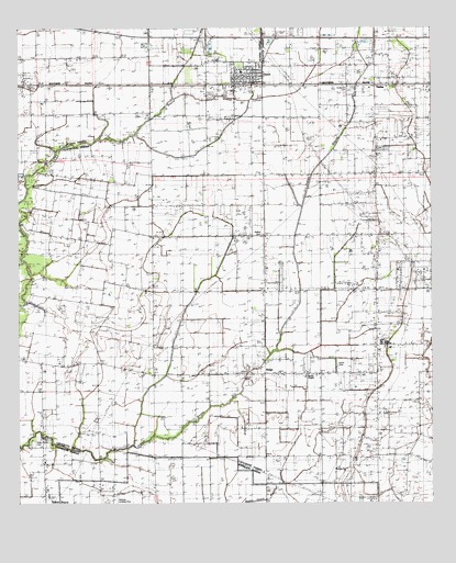
Duson, LA USGS Topographic Map
Click on map above to begin viewing in our Map Viewer.

This topographic map contains these locations and features:
Feature Name Type Latitude Longitude GNIS ID View Map
Anderson CemeteryCemeteryN30.2338°W92.1504°532163View Map
Bethel CemeteryCemeteryN30.1958°W92.1771°532970View Map
Bethel Church (historical)ChurchN30.1958°W92.1760°557248View Map
Bonnin School (historical)SchoolN30.1946°W92.2301°557249View Map
Burke School (historical)SchoolN30.1591°W92.1626°557253View Map
Charles M Burke Elementary SchoolSchoolN30.1798°W92.1737°2493423View Map
Clifton Mobile Home ParkPopulated PlaceN30.1954°W92.1427°2600805View Map
Country Air Mobile Home ParkPopulated PlaceN30.2437°W92.2134°2600810View Map
DusonPopulated PlaceN30.2358°W92.1854°558211View Map
Duson Elementary SchoolSchoolN30.2387°W92.1815°557278View Map
Duson Oil and Gas FieldOilfieldN30.1930°W92.1846°554304View Map
Duson Police DepartmentBuildingN30.2357°W92.1776°2334016View Map
Duson Post OfficePost OfficeN30.2360°W92.1843°1632206View Map
Duson Volunteer Fire Department Station 1BuildingN30.2357°W92.1781°2332591View Map
Duson Volunteer Fire Department Station 2BuildingN30.2263°W92.1764°2691820View Map
Duson Wastewater Treatment FacilityLocaleN30.2325°W92.1877°2603424View Map
Freebird FieldAirportN30.1294°W92.1351°1632804View Map
Gladney Airport (historical)AirportN30.1252°W92.2196°1632924View Map
Glenn's Strip Ultralight FlightparkAirportN30.2063°W92.2088°2717362View Map
Indian BayouPopulated PlaceN30.1260°W92.2426°543327View Map
Indian Bayou CemeteryCemeteryN30.1410°W92.2460°544219View Map
Indian Bayou Elementary SchoolSchoolN30.1273°W92.2413°544220View Map
Indian Bayou High SchoolSchoolN30.1271°W92.2412°544221View Map
Indian Bayou United Methodist ChurchChurchN30.1360°W92.2424°544222View Map
Indian CemeteryCemeteryN30.1410°W92.2462°535917View Map
Indice High SchoolSchoolN30.1671°W92.1410°535932View Map
Interchange 92CrossingN30.2477°W92.1932°541393View Map
J and J Mobile Home ParkPopulated PlaceN30.2241°W92.1834°2600429View Map
JudicePopulated PlaceN30.1813°W92.1418°557323View Map
Judice Middle SchoolSchoolN30.1673°W92.1407°557325View Map
Judice ParkParkN30.1610°W92.1526°557326View Map
Judice Volunteer Fire DepartmentBuildingN30.1723°W92.1371°2025914View Map
Kimball Chapel Methodist ChurchChurchN30.1588°W92.1632°554930View Map
Kingdom Hall of Jehovahs WitnessesChurchN30.1882°W92.1413°2602122View Map
KRRQ-FM (Lafayette)TowerN30.1741°W92.1332°1633069View Map
Lafayette Parish Library Duson BranchBuildingN30.2357°W92.1783°2603093View Map
Morning Star ChurchChurchN30.1341°W92.1515°537221View Map
Parish Governing Authority District BCivilN30.2223°W92.1389°1930300View Map
Pecan Acres Mobile Home ParkPopulated PlaceN30.2405°W92.1833°2600872View Map
Phoenix AirportAirportN30.2485°W92.2395°2676785View Map
Quiet Living Mobile Home ParkPopulated PlaceN30.1913°W92.1455°2600888View Map
RidgePopulated PlaceN30.1591°W92.1762°538598View Map
Ridge Elementary SchoolSchoolN30.1595°W92.1403°2493358View Map
Ridge Post Office (historical)Post OfficeN30.1591°W92.1782°1632135View Map
Royal Mobile Home ParkPopulated PlaceN30.2335°W92.1493°2600897View Map
SadouPopulated PlaceN30.2374°W92.1429°558304View Map
Saint Basil Catholic ChurchChurchN30.1660°W92.1381°2602605View Map
Saint Benedict the Moor ChurchChurchN30.2343°W92.1916°2602608View Map
Saint Theresas ChurchChurchN30.2369°W92.1822°2602770View Map
Scott Oil and Gas FieldOilfieldN30.2191°W92.1454°557401View Map
Smiling C Mobile Home ParkPopulated PlaceN30.1691°W92.1327°2600913View Map
Southeast Rayne Gas FieldOilfieldN30.2085°W92.2335°557404View Map
Southwest Ridge Gas FieldOilfieldN30.1683°W92.1701°557407View Map
Thibodeaux Mobile Home ParkPopulated PlaceN30.2488°W92.1714°2600937View Map
Town of DusonCivilN30.2361°W92.1922°2406407View Map
Townsite Gas FieldOilfieldN30.1960°W92.2404°557416View Map
West Ridge Oil and Gas FieldOilfieldN30.1602°W92.2346°557425View Map

Note: Coordinates in the location and feature list above are referenced to NAD83 datum.


Copyright (C) 2008-2025 Ryan Niemi / Sunset Dynamics ... All Rights Reserved