TopoQuest Logo
Do you find TopoQuest useful?
Help keep TopoQuest running and adding new maps/features by donating!
Bitcoin:  19c7KJd3qBynnjoSw5npx9KScwjBe4ifkT
Litecoin:  LXs6TkuXGGXo1vDsWCkWVdjQX94eUKd6ui
Home View Maps Find Maps Find Places Resources & Links


Milton-Freewater, Oregon Topographic Map

USGS Map Title: Milton-Freewater, OR
USGS Map MRC: 45118H4
DRG (GeoTIFF) Download: o45118h4.tif


Neighboring USGS Topographic Map Quads:


  Lowden, WA  
46118A5
 

  College Place, WA  
46118A4
 

  Walla Walla, WA  
46118A3
 

  Waterman, OR  
45118H5
 

  Milton-Freewater, OR  
45118H4
 

  Bowlus Hill, OR  
45118H3
 

  Adams, OR  
45118G5
 

  Athena, OR  
45118G4
 

  Weston Mountain, OR  
45118G3


Map MRC Location:

N46°
W119°
N46°
W118°
H8 H7 H6 H5 H4 H3 H2 H1
G8 G7 G6 G5 G4 G3 G2 G1
F8 F7 F6 F5 F4 F3 F2 F1
E8 E7 E6 E5 E4 E3 E2 E1
D8 D7 D6 D5 D4 D3 D2 D1
C8 C7 C6 C5 C4 C3 C2 C1
B8 B7 B6 B5 B4 B3 B2 B1
A8 A7 A6 A5 A4 A3 A2 A1
N45°
W119°
N45°
W118°

Milton-Freewater, OR USGS 1:24K Topographic Map Preview:
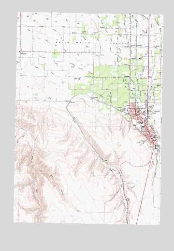
Milton-Freewater, OR USGS Topographic Map
Click on map above to begin viewing in our Map Viewer.

This topographic map contains these locations and features:
Feature Name Type Latitude Longitude GNIS ID View Map
BadeLocaleN45.9124°W118.4233°1136020View Map
BarrettLocaleN45.9471°W118.4530°1136036View Map
Bates (historical)LocaleN45.9218°W118.4355°1167746View Map
Central Middle SchoolSchoolN45.9333°W118.3922°1118791View Map
City of Milton-FreewaterCivilN45.9349°W118.3913°2411115View Map
CobbPopulated PlaceN45.9551°W118.3975°1136161View Map
Columbia HeightsSummitN45.9290°W118.3969°1638192View Map
CrockettPopulated PlaceN45.9735°W118.3975°1136194View Map
Davis OrchardsLocaleN45.9703°W118.4086°2563664View Map
Department of Motor Vehicles Milton FreewaterBuildingN45.9396°W118.3889°2700316View Map
Dry HollowValleyN45.9074°W118.4808°1120168View Map
East Crockett BranchStreamN45.9721°W118.3994°1120291View Map
East FordStreamN45.9624°W118.4077°1120293View Map
Eastside School (historical)SchoolN45.9578°W118.3797°1120368View Map
FerndalePopulated PlaceN45.9812°W118.3975°1136284View Map
Ferndale Elementary SchoolSchoolN45.9812°W118.4025°1120680View Map
Ford BranchStreamN45.9624°W118.4077°1120874View Map
Ford CemeteryCemeteryN45.9868°W118.4105°1120875View Map
Frazier Farmstead MuseumBuildingN45.9234°W118.3784°2699378View Map
Freewater Elementary SchoolSchoolN45.9435°W118.3983°1161855View Map
Freewater ParkParkN45.9278°W118.3797°1638193View Map
Fruitvale School (historical)SchoolN45.9878°W118.4439°1121016View Map
Goodman Spring BranchStreamN45.9726°W118.4705°1121231View Map
Grove Elementary SchoolSchoolN45.9219°W118.3775°1157413View Map
Hudson Bay (historical)AreaN45.9526°W118.4275°1851706View Map
Hudson Bay CanalCanalN45.9729°W118.4444°1122102View Map
Johns (historical)LocaleN45.9476°W118.4277°1167780View Map
Johnson CreekStreamN45.9757°W118.4916°1122475View Map
King's AirportAirportN45.9352°W118.4489°1131667View Map
Little Walla Walla RiverStreamN45.9451°W118.3936°1123306View Map
McLoughlin High SchoolSchoolN45.9354°W118.3915°1124004View Map
Middle Mud CreekStreamN45.9921°W118.4558°1124125View Map
Milton - Freewater Rural Fire Protection District Umapine StationBuildingN45.9764°W118.4963°2577047View Map
Milton - Freewater City Fire Department Station 1HeadquartersBuildingN45.9418°W118.3960°2576990View Map
Milton - Freewater City Fire Department Station 2BuildingN45.9275°W118.3836°2577090View Map
Milton - Freewater City HallBuildingN45.9280°W118.3857°2700386View Map
Milton - Freewater Municipal CourtBuildingN45.9280°W118.3857°2700387View Map
Milton - Freewater Post OfficePost OfficeN45.9369°W118.3966°1165640View Map
Milton - Freewater Public LibraryBuildingN45.9278°W118.3854°2700385View Map
Milton - Freewater Public Works DepartmentBuildingN45.9409°W118.4036°2700291View Map
Milton - Freewater Rural Fire District Eastside StationBuildingN45.9644°W118.3765°2576995View Map
Milton - Freewater Rural Fire District North StationBuildingN45.9661°W118.3752°2576581View Map
Milton - Freewater Sewage Treatment PlantLocaleN45.9433°W118.4097°2697180View Map
Milton DitchCanalN45.9251°W118.3839°1124224View Map
Milton Freewater Police DepartmentBuildingN45.9281°W118.3857°2737771View Map
Milton HillSummitN45.9096°W118.4025°1129671View Map
Milton Stateline Seventh Day Adventist SchoolSchoolN45.9735°W118.3953°1124226View Map
Milton SubstationLocaleN45.9215°W118.3822°1124227View Map
Milton-FreewaterPopulated PlaceN45.9326°W118.3877°1167716View Map
Nichols CanyonValleyN45.9179°W118.3764°1124678View Map
North Umatilla County Sheriff's OfficeBuildingN45.9409°W118.3973°2770146View Map
Old City CemeteryCemeteryN45.9237°W118.3925°1124960View Map
Oregon Sky Ranch AirportAirportN45.8795°W118.4039°1131676View Map
Pleasant View CanalCanalN45.9440°W118.4075°1125487View Map
Pleasant View SchoolSchoolN45.9616°W118.4451°1125489View Map
PrunedaleLocaleN45.9496°W118.4336°1125686View Map
South Post Office (historical)Post OfficeN45.9260°W118.3825°1164697View Map
SunnysidePopulated PlaceN45.9624°W118.4022°1136801View Map
Tumalum School (historical)SchoolN45.9803°W118.3817°1128292View Map
UmapinePopulated PlaceN45.9765°W118.4964°1136855View Map
Umapine DivisionCivilN45.9814°W118.4934°1938140View Map
Umapine High and Elementary School (historical)SchoolN45.9761°W118.4975°1638194View Map
Umapine Post Office (historical)Post OfficeN45.9765°W118.4964°1166079View Map
W. W. V. Ry. CrossingLocaleN45.9401°W118.3955°1167838View Map
West Branch West Crockett BranchStreamN45.9824°W118.4166°1128813View Map
West Crockett BranchStreamN45.9721°W118.3994°1128824View Map
West FordStreamN45.9624°W118.4077°1128831View Map
Yantis ParkParkN45.9318°W118.3939°1125979View Map

Note: Coordinates in the location and feature list above are referenced to NAD83 datum.


Copyright (C) 2008-2024 Ryan Niemi / Sunset Dynamics ... All Rights Reserved