TopoQuest Logo
Do you find TopoQuest useful?
Help keep TopoQuest running and adding new maps/features by donating!
Bitcoin:  19c7KJd3qBynnjoSw5npx9KScwjBe4ifkT
Litecoin:  LXs6TkuXGGXo1vDsWCkWVdjQX94eUKd6ui
Home View Maps Find Maps Find Places Resources & Links


Miner, Montana Topographic Map

USGS Map Title: Miner, MT
USGS Map MRC: 45110B8
DRG (GeoTIFF) Download: o45110b8.tif


Neighboring USGS Topographic Map Quads:


  The Sentinel, MT  
45111C1
 

  Lewis Creek, MT  
45110C8
 

  Dailey Lake, MT  
45110C7
 

  Ramshorn Peak, MT  
45111B1
 

  Miner, MT  
45110B8
 

  Dome Mountain, MT  
45110B7
 

  Big Horn Peak, MT  
45111A1
 

  Sportsman Lake, MT  
45110A8
 

  Electric Peak, MT  
45110A7


Map MRC Location:

N46°
W111°
N46°
W110°
H8 H7 H6 H5 H4 H3 H2 H1
G8 G7 G6 G5 G4 G3 G2 G1
F8 F7 F6 F5 F4 F3 F2 F1
E8 E7 E6 E5 E4 E3 E2 E1
D8 D7 D6 D5 D4 D3 D2 D1
C8 C7 C6 C5 C4 C3 C2 C1
B8 B7 B6 B5 B4 B3 B2 B1
A8 A7 A6 A5 A4 A3 A2 A1
N45°
W111°
N45°
W110°

Miner, MT USGS 1:24K Topographic Map Preview:
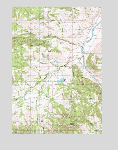
Miner, MT USGS Topographic Map
Click on map above to begin viewing in our Map Viewer.

This topographic map contains these locations and features:
Feature Name Type Latitude Longitude GNIS ID View Map
Black MountainSummitN45.1319°W110.9227°794521View Map
Canyon CreekStreamN45.1905°W110.9352°780894View Map
CarbellaPopulated PlaceN45.2077°W110.9047°780930View Map
Carbella (historical)LocaleN45.2077°W110.9047°1743194View Map
Carbella CampgroundLocaleN45.2113°W110.9030°1743072View Map
Carbella Post Office (historical)Post OfficeN45.2077°W110.9047°1743196View Map
Carbella Recreation SiteLocaleN45.2113°W110.9030°794558View Map
Carbella School (historical)SchoolN45.2077°W110.9047°1743257View Map
Crystal Cross MountainSummitN45.2055°W110.9522°781957View Map
Divide CreekStreamN45.1783°W110.9577°782403View Map
Dog Tooth RockPillarN45.2122°W110.9747°782447View Map
Ferrell CreekStreamN45.1944°W110.9466°783360View Map
Ferrell LakeLakeN45.1957°W110.9380°783361View Map
Fisher CreekStreamN45.2241°W110.9741°783452View Map
Green LakeLakeN45.1593°W110.8887°784285View Map
Grizzly CreekStreamN45.1355°W110.9652°784355View Map
Horse CreekStreamN45.1766°W110.9608°785039View Map
Mans Foot MountainSummitN45.1344°W110.9208°806040View Map
Merrell DamDamN45.1783°W110.9291°795329View Map
Merrell LakeLakeN45.1775°W110.9330°787187View Map
Middle CreekStreamN45.1597°W110.9927°787229View Map
MinerPopulated PlaceN45.1991°W110.9086°787451View Map
Miner Post Office (historical)Post OfficeN45.1991°W110.9086°1743195View Map
Miner School (historical)SchoolN45.1616°W110.9636°787458View Map
Pine CreekStreamN45.1610°W110.9880°788885View Map
Quaking Ash HollowValleyN45.1255°W110.8813°807036View Map
Reeder CreekStreamN45.1783°W110.9577°789505View Map
Rock CreekStreamN45.2108°W110.9030°789683View Map
Sharp CreekStreamN45.1610°W110.9883°790288View Map
SphinxPopulated PlaceN45.1710°W110.8780°791149View Map
Stoughten CreekStreamN45.2180°W110.9311°791575View Map
Tepee CreekStreamN45.1972°W110.9152°791983View Map
Tom Miner BasinBasinN45.1847°W110.9538°792252View Map
Tom Miner CreekStreamN45.2013°W110.9030°792253View Map
Wigwam CreekStreamN45.1780°W110.9180°793275View Map
Yankee Jim Campground and Picnic AreaLocaleN45.1797°W110.8816°778723View Map
Yankee Jim CanyonValleyN45.1952°W110.9013°793592View Map

Note: Coordinates in the location and feature list above are referenced to NAD83 datum.


Copyright (C) 2008-2025 Ryan Niemi / Sunset Dynamics ... All Rights Reserved