TopoQuest Logo
Do you find TopoQuest useful?
Help keep TopoQuest running and adding new maps/features by donating!
Bitcoin:  19c7KJd3qBynnjoSw5npx9KScwjBe4ifkT
Litecoin:  LXs6TkuXGGXo1vDsWCkWVdjQX94eUKd6ui
Home View Maps Find Maps Find Places Resources & Links


Mission, Oregon Topographic Map

USGS Map Title: Mission, OR
USGS Map MRC: 45118F6
DRG (GeoTIFF) Download: o45118f6.tif


Neighboring USGS Topographic Map Quads:


  Holdman SE, OR  
45118G7
 

  Helix, OR  
45118G6
 

  Adams, OR  
45118G5
 

  Pendleton, OR  
45118F7
 

  Mission, OR  
45118F6
 

  Cayuse, OR  
45118F5
 

  McKay Reservoir, OR  
45118E7
 

  Table Rock, OR  
45118E6
 

  Cabbage Hill, OR  
45118E5


Map MRC Location:

N46°
W119°
N46°
W118°
H8 H7 H6 H5 H4 H3 H2 H1
G8 G7 G6 G5 G4 G3 G2 G1
F8 F7 F6 F5 F4 F3 F2 F1
E8 E7 E6 E5 E4 E3 E2 E1
D8 D7 D6 D5 D4 D3 D2 D1
C8 C7 C6 C5 C4 C3 C2 C1
B8 B7 B6 B5 B4 B3 B2 B1
A8 A7 A6 A5 A4 A3 A2 A1
N45°
W119°
N45°
W118°

Mission, OR USGS 1:24K Topographic Map Preview:
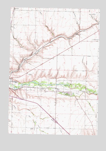
Mission, OR USGS Topographic Map
Click on map above to begin viewing in our Map Viewer.

This topographic map contains these locations and features:
Feature Name Type Latitude Longitude GNIS ID View Map
Agency Indian CemeteryCemeteryN45.6637°W118.6697°1163879View Map
FultonPopulated PlaceN45.7304°W118.7492°1136307View Map
Gopher FlatsFlatN45.6655°W118.7258°2413603View Map
Gopher Flats Census Designated PlaceCensusN45.6659°W118.7225°2408309View Map
HavanaLocaleN45.7249°W118.6569°1136364View Map
Indian Agency HeadquartersBuildingN45.6662°W118.6730°1122195View Map
Indian Ceremonial GroundLocaleN45.6646°W118.6628°1122202View Map
KirkpatrickPopulated PlaceN45.6785°W118.6630°2413634View Map
Kirkpatrick Census Designated PlaceCensusN45.6796°W118.6499°2408488View Map
KUMA - AMTowerN45.6740°W118.7488°1158759View Map
Little Greasewood CreekStreamN45.7349°W118.6272°1123201View Map
McCormmach (historical)LocaleN45.7479°W118.7455°1136521View Map
McCormmach CreekStreamN45.7276°W118.6519°1123921View Map
MissionPopulated PlaceN45.6704°W118.6836°1124254View Map
Mission Census Designated PlaceCensusN45.6586°W118.6655°2408844View Map
Mission CreekStreamN45.6715°W118.6475°1124256View Map
Munra (historical)LocaleN45.6710°W118.7308°1136560View Map
Nixyaawii Community SchoolSchoolN45.6653°W118.6639°2490559View Map
North Coyote CreekStreamN45.6474°W118.7325°1124735View Map
Old Agency CemeteryCemeteryN45.6675°W118.7002°1124952View Map
Oregon State University Agricultural Experiment StationLocaleN45.7198°W118.6270°1638979View Map
RiversidePopulated PlaceN45.6752°W118.7373°2413666View Map
Riverside Census Designated PlaceCensusN45.6768°W118.7368°2409188View Map
Riverside School (historical)SchoolN45.6786°W118.7483°1126071View Map
Rothrock Landing Strip (historical)AirportN45.7443°W118.6308°1157414View Map
Roundup SubstationLocaleN45.6374°W118.7464°1126338View Map
Saint Andrews Mission CemeteryCemeteryN45.6351°W118.6252°1126450View Map
SaxeLocaleN45.7082°W118.7080°1129675View Map
South Patawa CreekStreamN45.6421°W118.7133°1127336View Map
Spring CreekStreamN45.7187°W118.6872°1127434View Map
Spring CreekStreamN45.6707°W118.6594°1129676View Map
Tamástslikt Cultural InstituteBuildingN45.6544°W118.6625°2699867View Map
Tutuilla MissionLocaleN45.6308°W118.7157°1128328View Map
Tutuilla Presbyterian Indian Mission CemeteryCemeteryN45.6296°W118.7164°1163880View Map
Umatilla Indian Police DepartmentBuildingN45.6654°W118.6862°2737693View Map
Umatilla National Forest Law Enforcement and InvestigationsBuildingN45.6422°W118.6863°2737737View Map
Umatilla Post Office (historical)Post OfficeN45.6679°W118.6991°1164743View Map
Umatilla Tribal Fire DepartmentBuildingN45.6662°W118.6706°2576610View Map
Woodpecker Landing Strip (historical)AirportN45.6840°W118.7219°1157415View Map

Note: Coordinates in the location and feature list above are referenced to NAD83 datum.


Copyright (C) 2008-2024 Ryan Niemi / Sunset Dynamics ... All Rights Reserved