TopoQuest Logo
Do you find TopoQuest useful?
Help keep TopoQuest running and adding new maps/features by donating!
Bitcoin:  19c7KJd3qBynnjoSw5npx9KScwjBe4ifkT
Litecoin:  LXs6TkuXGGXo1vDsWCkWVdjQX94eUKd6ui
Home View Maps Find Maps Find Places Resources & Links


Mission Bottom, Oregon Topographic Map

USGS Map Title: Mission Bottom, OR
USGS Map MRC: 45123A1
DRG (GeoTIFF) Download: o45123a1.tif


Neighboring USGS Topographic Map Quads:


  McMinnville, OR  
45123B2
 

  Dayton, OR  
45123B1
 

  Saint Paul, OR  
45122B8
 

  Amity, OR  
45123A2
 

  Mission Bottom, OR  
45123A1
 

  Gervais, OR  
45122A8
 

  Rickreall, OR  
44123H2
 

  Salem West, OR  
44123H1
 

  Salem East, OR  
44122H8


Map MRC Location:

N46°
W124°
N46°
W123°
H8 H7 H6 H5 H4 H3 H2 H1
G8 G7 G6 G5 G4 G3 G2 G1
F8 F7 F6 F5 F4 F3 F2 F1
E8 E7 E6 E5 E4 E3 E2 E1
D8 D7 D6 D5 D4 D3 D2 D1
C8 C7 C6 C5 C4 C3 C2 C1
B8 B7 B6 B5 B4 B3 B2 B1
A8 A7 A6 A5 A4 A3 A2 A1
N45°
W124°
N45°
W123°

Mission Bottom, OR USGS 1:24K Topographic Map Preview:
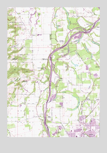
Mission Bottom, OR USGS Topographic Map
Click on map above to begin viewing in our Map Viewer.

This topographic map contains these locations and features:
Feature Name Type Latitude Longitude GNIS ID View Map
Aquatic GardensLakeN45.1058°W123.0588°1117023View Map
Beaver IslandFlatN45.0823°W123.0507°1117448View Map
Canyon CreekStreamN45.0901°W123.1109°1130182View Map
Case ReservoirsReservoirN45.0641°W123.0924°1157389View Map
Chemawa BPA Spur (historical)LocaleN45.0112°W123.0015°1167995View Map
Chemawa Station (historical)LocaleN45.0057°W123.0015°1167996View Map
City of KeizerCivilN45.0029°W123.0241°2410171View Map
Claggett CemeteryCemeteryN45.0151°W123.0284°1118961View Map
Claggett CreekStreamN45.0287°W123.0304°1157964View Map
Clear LakeLakeN45.0275°W123.0337°1119001View Map
Clear LakePopulated PlaceN45.0354°W123.0209°1119004View Map
Clear Lake Boat RampLocaleN45.0321°W123.0289°2699253View Map
Clear Lake Elementary SchoolSchoolN45.0268°W123.0190°2485893View Map
Clear Lake Golf CourseLocaleN45.0123°W123.0318°1163690View Map
Curry LakeLakeN45.1172°W123.0610°1119641View Map
Darrow BarBarN45.0043°W123.0712°1119691View Map
Darrow ChuteChannelN45.0026°W123.0720°1158078View Map
Deep LakeLakeN45.0776°W123.0124°1130180View Map
Ediger Landing County Park Boat RampLocaleN45.0907°W123.0461°2668217View Map
Eldriedge BarBarN45.1112°W123.0037°1120431View Map
Eldriedge LandingLocaleN45.1068°W123.0045°1161357View Map
Eldriedge SloughLakeN45.1094°W123.0009°1120432View Map
Eola HillsRangeN45.0754°W123.1237°1120513View Map
Finney Lake Airport (historical)AirportN45.0707°W123.0068°1638173View Map
Forest Ridge Elementary SchoolSchoolN45.0339°W123.0199°2485911View Map
Goffrier PondReservoirN45.0743°W123.0941°1157390View Map
Goose LakeLakeN45.0662°W123.0447°1121244View Map
Gubser Elementary SchoolSchoolN45.0150°W123.0125°2485916View Map
Hills ReservoirReservoirN45.0449°W123.1005°1130178View Map
HopewellPopulated PlaceN45.0971°W123.0920°1136392View Map
Hopewell CemeteryCemeteryN45.1040°W123.1026°1130673View Map
Hopewell Post Office (historical)Post OfficeN45.0971°W123.0920°1165409View Map
Hubbard LakeLakeN45.0901°W123.0055°1122093View Map
Janzen ReservoirReservoirN45.1088°W123.0872°1130177View Map
Jason Lee Mission Historical MarkerParkN45.0843°W123.0443°1163723View Map
Jerusalem HillRidgeN45.0862°W123.1037°1157997View Map
Keene DamDamN45.1187°W123.0845°1158843View Map
Keene ReservoirReservoirN45.1175°W123.0850°1122644View Map
Keizer Elementary SchoolSchoolN45.0062°W123.0398°2097341View Map
Keizer Post OfficePost OfficeN45.0041°W123.0238°1165472View Map
King CreekStreamN45.0648°W123.0687°1122748View Map
Labish CreekStreamN45.0129°W123.0262°1638764View Map
LakebrookPopulated PlaceN45.0282°W123.0504°1122915View Map
LincolnPopulated PlaceN45.0198°W123.0840°1136479View Map
Lincoln BarBarN45.0340°W123.0679°1123092View Map
Lincoln Post Office (historical)Post OfficeN45.0198°W123.0840°1165545View Map
Lincoln RocksBarN45.0168°W123.0757°1123098View Map
Lone Tree BarBarN45.0687°W123.0623°1158005View Map
Lower Martine BarBarN45.1012°W123.0245°1158006View Map
Lower Simon BarBarN45.0582°W123.0559°1158007View Map
Marion County Fire District 1 Station 6 WheatlandBuildingN45.0355°W123.0217°2576726View Map
Matheny BarBarN45.1040°W123.0151°1157416View Map
Maud Williamson State ParkParkN45.0965°W123.0670°1123846View Map
McCall BarBarN45.0357°W123.0643°1158009View Map
McCloskie BarBarN45.0479°W123.0604°1158010View Map
McNary High SchoolSchoolN45.0007°W123.0329°2486045View Map
Migrant Primary SchoolSchoolN45.0356°W123.0217°2486046View Map
Mission BottomBendN45.0585°W123.0393°1124255View Map
Mission LakeLakeN45.0784°W123.0482°1161444View Map
Northridge ParkParkN45.0004°W123.0165°1157917View Map
Northside County ParkParkN45.0037°W123.0220°1638175View Map
Nygren ReservoirReservoirN45.0773°W123.0887°1161030View Map
Optimum Learning Environment Charter SchoolSchoolN45.0339°W123.0199°2559635View Map
Patterson CreekStreamN45.1068°W123.0045°1125230View Map
Pine Tree CornerLocaleN45.0998°W123.0679°1130176View Map
Polvi ReservoirReservoirN45.1062°W123.1125°1161031View Map
QuinabyLocaleN45.0351°W123.0001°1125752View Map
Ryan LakeLakeN45.0842°W123.0187°1130181View Map
Salem Public Works Department Willow Lake OfficeBuildingN45.0096°W123.0538°2699784View Map
Salem Willow Lake Wastewater Treatment FacilityLocaleN45.0095°W123.0537°2697085View Map
Schindler ReservoirReservoirN45.0758°W123.1038°1130179View Map
Simon LandingLocaleN45.0565°W123.0548°1161511View Map
Snaggy BendBendN45.1187°W123.0073°1127146View Map
Spongs BarBarN45.0262°W123.0726°1127398View Map
Spongs LandingLocaleN45.0204°W123.0726°1161527View Map
Spongs Landing County ParkParkN45.0162°W123.0704°1638172View Map
Spring ValleyValleyN45.0540°W123.0726°1127454View Map
Spring Valley Community CenterLocaleN45.0540°W123.0982°1127455View Map
Spring Valley CreekStreamN45.0748°W123.0695°1158039View Map
Spring Valley Post Office (historical)Post OfficeN45.0540°W123.0984°1165975View Map
Stephens FarmLocaleN45.1200°W123.0050°2663963View Map
Stephens ReservoirReservoirN45.1123°W123.0948°1130175View Map
Tompkins LandingLocaleN45.1087°W123.0104°1161558View Map
Union BarBarN45.0776°W123.0670°1157417View Map
Upper Martine BarBarN45.1051°W123.0284°1158045View Map
Upper Simon BarBarN45.0546°W123.0559°1158046View Map
Valfontis Post Office (historical)Post OfficeN45.0198°W123.0804°1164752View Map
Walker CreekStreamN45.0223°W123.1009°1158048View Map
Western Mennonite SchoolSchoolN45.0657°W123.0760°1128911View Map
WheatlandPopulated PlaceN45.0926°W123.0501°1136896View Map
Wheatland BarBarN45.0973°W123.0376°1158055View Map
Wheatland Dam (historical)DamN45.1029°W123.0387°1158056View Map
Wheatland FerryLocaleN45.0907°W123.0457°1158057View Map
Wheatland Ferry Landing EastLocaleN45.0900°W123.0444°2699945View Map
Wheatland Ferry Landing WestLocaleN45.0906°W123.0462°2668568View Map
Wheatland Post Office (historical)Post OfficeN45.0926°W123.0501°1166165View Map
Whiteaker Middle SchoolSchoolN45.0068°W123.0113°1638176View Map
Wilark County ParkParkN45.0101°W123.0170°1638174View Map
Willamette Mission State ParkParkN45.0754°W123.0501°1166782View Map
Willamette Mission State Park Boat RampLocaleN45.0929°W123.0414°2699950View Map
Willamette Mission State Park Mission Lake Boat RampLocaleN45.0780°W123.0518°2699951View Map
Willow LakeLakeN45.0059°W123.0580°1129154View Map
Windsor BarBarN45.0548°W123.0687°1129219View Map
Windsor IslandIslandN45.0498°W123.0632°1158062View Map
Windsor Island ReachChannelN45.0423°W123.0679°1158063View Map

Note: Coordinates in the location and feature list above are referenced to NAD83 datum.


Copyright (C) 2008-2025 Ryan Niemi / Sunset Dynamics ... All Rights Reserved