TopoQuest Logo
Do you find TopoQuest useful?
Help keep TopoQuest running and adding new maps/features by donating!
Bitcoin:  19c7KJd3qBynnjoSw5npx9KScwjBe4ifkT
Litecoin:  LXs6TkuXGGXo1vDsWCkWVdjQX94eUKd6ui
Home View Maps Find Maps Find Places Resources & Links


Rickreall, Oregon Topographic Map

USGS Map Title: Rickreall, OR
USGS Map MRC: 44123H2
DRG (GeoTIFF) Download: o44123h2.tif


Neighboring USGS Topographic Map Quads:


  Ballston, OR  
45123A3
 

  Amity, OR  
45123A2
 

  Mission Bottom, OR  
45123A1
 

  Dallas, OR  
44123H3
 

  Rickreall, OR  
44123H2
 

  Salem West, OR  
44123H1
 

  Airlie North, OR  
44123G3
 

  Monmouth, OR  
44123G2
 

  Sidney, OR  
44123G1


Map MRC Location:

N45°
W124°
N45°
W123°
H8 H7 H6 H5 H4 H3 H2 H1
G8 G7 G6 G5 G4 G3 G2 G1
F8 F7 F6 F5 F4 F3 F2 F1
E8 E7 E6 E5 E4 E3 E2 E1
D8 D7 D6 D5 D4 D3 D2 D1
C8 C7 C6 C5 C4 C3 C2 C1
B8 B7 B6 B5 B4 B3 B2 B1
A8 A7 A6 A5 A4 A3 A2 A1
N44°
W124°
N44°
W123°

Rickreall, OR USGS 1:24K Topographic Map Preview:
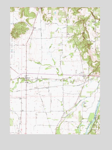
Rickreall, OR USGS Topographic Map
Click on map above to begin viewing in our Map Viewer.

This topographic map contains these locations and features:
Feature Name Type Latitude Longitude GNIS ID View Map
Bald HillSummitN44.9973°W123.1543°1117174View Map
Baskett SloughStreamN44.9279°W123.1809°1162829View Map
Beyers PondReservoirN44.9265°W123.1756°1163447View Map
Boeder PondReservoirN44.9845°W123.2485°1161040View Map
Brophy (historical)LocaleN44.9312°W123.1312°1166355View Map
Brunks CornerLocaleN44.9329°W123.1476°1162855View Map
Cascade Airstrip (historical)AirportN44.9157°W123.2304°1163588View Map
Cherriots Rickreall Park and RideLocaleN44.9307°W123.2331°2697232View Map
Clow CornerLocaleN44.8976°W123.2351°1162907View Map
Cochrane (historical)Populated PlaceN44.8846°W123.2373°1166740View Map
Croston Post Office (historical)Post OfficeN44.8840°W123.1359°1164295View Map
CrowleyLocaleN44.9785°W123.2082°1166637View Map
Crowley CreekStreamN44.9523°W123.1937°1157967View Map
Crowley Post Office (historical)Post OfficeN44.9785°W123.2082°1165116View Map
DerryLocaleN44.9298°W123.2132°1162938View Map
Derry Orchard (historical)LocaleN44.8751°W123.1873°1166358View Map
Eagle Crest CornerLocaleN44.9846°W123.1326°1136237View Map
Eagle Crest ReservoirReservoirN44.9776°W123.1344°1130213View Map
Eagle Crest SpringSpringN44.9943°W123.1595°1130212View Map
Etna CemeteryCemeteryN44.9771°W123.2288°1120525View Map
Etna Post Office (historical)Post OfficeN44.9665°W123.2179°1164342View Map
Fidler CreekStreamN44.8885°W123.1329°1162986View Map
GerlingerLocaleN44.9204°W123.2132°1166656View Map
Goodwin Branch Mud SloughStreamN44.9640°W123.1932°1163016View Map
Greenwood (historical)LocaleN44.9232°W123.1776°1163448View Map
Greenwood School (historical)SchoolN44.9271°W123.1770°1163024View Map
Halls FerryLocaleN44.8835°W123.1343°1121525View Map
Harland SloughStreamN44.9543°W123.2498°1163031View Map
Hayden LakeLakeN44.9047°W123.1500°1163037View Map
Holmes GapGapN44.9987°W123.2098°1121930View Map
Holmes HillSummitN44.9932°W123.1990°1121931View Map
Hosford (historical)LocaleN44.9301°W123.1365°1166363View Map
Humbug LakeLakeN44.8843°W123.1527°1163059View Map
Knowles (historical)LocaleN44.9221°W123.1934°1166365View Map
KSKD-FMTowerN44.9982°W123.1520°1158725View Map
Marx DamDamN44.9932°W123.1862°1133603View Map
Marx ReservoirReservoirN44.9944°W123.1887°1130211View Map
McMahan BranchStreamN44.9787°W123.1843°1163135View Map
McNary (historical)LocaleN44.9262°W123.1476°1161036View Map
McNary BranchStreamN44.9448°W123.1890°1124012View Map
McNary CreekStreamN44.9287°W123.1420°1163137View Map
Mineral CreekStreamN44.8782°W123.1409°1132746View Map
Mineral CreekStreamN44.8818°W123.1387°1163445View Map
Mud SloughStreamN44.9415°W123.1876°1163168View Map
Mulkey (historical)LocaleN44.9068°W123.2484°1162629View Map
Myers ReservoirReservoirN44.9285°W123.1558°1163446View Map
Nelson SpringSpringN44.9746°W123.1501°1124652View Map
Nesmith (historical)LocaleN44.9179°W123.2290°1166739View Map
Nesmith County ParkParkN44.9304°W123.2295°2058222View Map
O'Brien Place (historical)LocaleN44.9040°W123.2026°1166560View Map
Oak GroveLocaleN44.9726°W123.1723°1136590View Map
Oak Knoll Golf CourseLocaleN44.9368°W123.1590°1163747View Map
Oak Point CreekStreamN44.9029°W123.1584°1163184View Map
Orrs CornerLocaleN44.9101°W123.2351°1125047View Map
Parks Lake ReservoirReservoirN44.9545°W123.1972°1130184View Map
Pentacle TheatreBuildingN44.9365°W123.1361°2661201View Map
Polk County FairgroundsLocaleN44.9257°W123.2262°1161039View Map
Polk County FairgroundsLocaleN44.9255°W123.2273°1131039View Map
Polk County MuseumBuildingN44.9240°W123.2276°2661566View Map
Restlawn Memory GardensCemeteryN44.9346°W123.1498°1163218View Map
Richards CreekStreamN44.9821°W123.1712°1163220View Map
RickreallPopulated PlaceN44.9307°W123.2284°1163222View Map
Rickreall Census Designated PlaceCensusN44.9319°W123.2343°2409167View Map
Rickreall Post OfficePost OfficeN44.9315°W123.2297°1165855View Map
Ross ReservoirReservoirN44.9278°W123.2488°1161038View Map
Salem DivisionCivilN44.9840°W123.1298°1938110View Map
Social Security HoleParkN44.8871°W123.1393°2058225View Map
Southwest Polk County Rural Fire Protection District Station 130BuildingN44.9314°W123.2290°2576746View Map
Steel Systems Airstrip (historical)AirportN44.9329°W123.1304°1163630View Map
Stevens ReservoirReservoirN44.9854°W123.1598°1163487View Map
ThielsenLocaleN44.9210°W123.2012°1163300View Map
Walkers CornerLocaleN44.9793°W123.2187°1163329View Map
Willamette Biomass Processor'sLocaleN44.9204°W123.2297°2697287View Map

Note: Coordinates in the location and feature list above are referenced to NAD83 datum.


Copyright (C) 2008-2024 Ryan Niemi / Sunset Dynamics ... All Rights Reserved