TopoQuest Logo
Do you find TopoQuest useful?
Help keep TopoQuest running and adding new maps/features by donating!
Bitcoin:  19c7KJd3qBynnjoSw5npx9KScwjBe4ifkT
Litecoin:  LXs6TkuXGGXo1vDsWCkWVdjQX94eUKd6ui
Home View Maps Find Maps Find Places Resources & Links


Beckemeyer, Illinois Topographic Map

USGS Map Title: Beckemeyer, IL
USGS Map MRC: 38089E4
DRG (GeoTIFF) Download: o38089e4.tif


Neighboring USGS Topographic Map Quads:


  Saint Rose, IL  
38089F5
 

  Stolletown, IL  
38089F4
 

  Keyesport, IL  
38089F3
 

  Breese, IL  
38089E5
 

  Beckemeyer, IL  
38089E4
 

  Carlyle, IL  
38089E3
 

  Okawville, IL  
38089D5
 

  Addieville, IL  
38089D4
 

  Hoyleton, IL  
38089D3


Map MRC Location:

N39°
W90°
N39°
W89°
H8 H7 H6 H5 H4 H3 H2 H1
G8 G7 G6 G5 G4 G3 G2 G1
F8 F7 F6 F5 F4 F3 F2 F1
E8 E7 E6 E5 E4 E3 E2 E1
D8 D7 D6 D5 D4 D3 D2 D1
C8 C7 C6 C5 C4 C3 C2 C1
B8 B7 B6 B5 B4 B3 B2 B1
A8 A7 A6 A5 A4 A3 A2 A1
N38°
W90°
N38°
W89°

Beckemeyer, IL USGS 1:24K Topographic Map Preview:
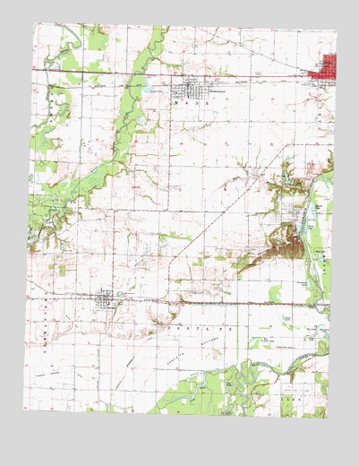
Beckemeyer, IL USGS Topographic Map
Click on map above to begin viewing in our Map Viewer.

This topographic map contains these locations and features:
Feature Name Type Latitude Longitude GNIS ID View Map
Appeal School (historical)SchoolN38.5206°W89.3801°1736355View Map
BartelsoPopulated PlaceN38.5364°W89.4665°403937View Map
Bartelso East Oil FieldOilfieldN38.5078°W89.3867°424600View Map
Bartelso Elementary SchoolSchoolN38.5350°W89.4659°1810413View Map
Bartelso Oil FieldOilfieldN38.5517°W89.4512°424601View Map
Bartelso Post OfficePost OfficeN38.5353°W89.4670°2788368View Map
Bartelso Water Treatment PlantLocaleN38.5372°W89.4700°2740887View Map
Bartelso West Oil FieldOilfieldN38.5284°W89.4809°424602View Map
Bear LakeLakeN38.5516°W89.3793°404030View Map
Beaver CreekStreamN38.5562°W89.4970°404055View Map
BeckemeyerPopulated PlaceN38.6056°W89.4359°404073View Map
Beckemeyer - Wade Volunteer Fire Protection DistrictBuildingN38.6045°W89.4362°2640886View Map
Beckemeyer CemeteryCemeteryN38.6087°W89.4534°404074View Map
Beckemeyer Elementary SchoolSchoolN38.6023°W89.4356°1810414View Map
Beckemeyer Post OfficePost OfficeN38.6059°W89.4361°2788753View Map
Becker School (historical)SchoolN38.5656°W89.4562°1736357View Map
Big Swan LakeSwampN38.5237°W89.4059°404439View Map
Blanke LakeLakeN38.5665°W89.3828°404554View Map
Bluff Lake (historical)LakeN38.6187°W89.4704°1736359View Map
Calamus Lake (historical)LakeN38.6070°W89.4712°1736367View Map
Camp JoyLocaleN38.5756°W89.3904°405478View Map
Clinton CountyCivilN38.6065°W89.4225°424215View Map
Clinton County FairgroundLocaleN38.6075°W89.3840°1736375View Map
Club LakeLakeN38.5260°W89.3763°1736377View Map
Colmers Ferry (historical)LocaleN38.5648°W89.3862°1736381View Map
Cow LakeLakeN38.5085°W89.4163°406678View Map
Crocker School (historical)SchoolN38.6170°W89.4095°1736383View Map
Dennis Meier HeliportAirportN38.6112°W89.4954°427084View Map
Germantown East Oil FieldOilfieldN38.5628°W89.4937°424913View Map
Goose LakeLakeN38.5316°W89.3939°409170View Map
Grassy Lake (historical)LakeN38.5112°W89.4023°1736389View Map
Greenville Old City LakeReservoirN38.5917°W89.4417°1691693View Map
Greenville Old City Lake DamDamN38.5917°W89.4417°1691692View Map
Hanover LeveeLeveeN38.5137°W89.4690°409753View Map
Hog LakeLakeN38.5302°W89.3785°410352View Map
Horseshoe LakeLakeN38.5270°W89.3767°410576View Map
Immanuel United Church of ChristChurchN38.6137°W89.3831°1810438View Map
Ira Maddux CemeteryCemeteryN38.5398°W89.4273°412823View Map
Johnson CemeteryCemeteryN38.5525°W89.4090°1965734View Map
Lake JoyReservoirN38.5769°W89.3942°411265View Map
Lake Joy DamDamN38.5756°W89.3937°1692040View Map
Little Swan LakeSwampN38.5227°W89.3995°412421View Map
Little York BranchStreamN38.5745°W89.3840°412437View Map
Little York School (historical)SchoolN38.5806°W89.4012°1736399View Map
Locey CemeteryCemeteryN38.5617°W89.3954°412462View Map
Loepker Dairy FarmLocaleN38.5428°W89.4400°2706244View Map
Long LakeLakeN38.5085°W89.4287°412572View Map
Mossy LakeLakeN38.5611°W89.3858°413889View Map
Pelican PouchRidgeN38.5545°W89.3995°415515View Map
Ridge School (historical)SchoolN38.5539°W89.4223°1736411View Map
Royal Lake ResortPopulated PlaceN38.5656°W89.3934°1810453View Map
Saint Anthony CemeteryCemeteryN38.5975°W89.4479°417176View Map
Saint Anthonys Catholic ChurchChurchN38.6037°W89.4406°1968127View Map
Saint Cecelia CemeteryCemeteryN38.5362°W89.4629°417231View Map
Saint Cecilia Parish CenterChurchN38.5356°W89.4659°1968128View Map
Santa Fe BottomsFlatN38.5234°W89.4323°418009View Map
Santa Fe Drainage DitchCanalN38.5250°W89.4448°418011View Map
Santa Fe Fire Protection DistrictBuildingN38.5367°W89.4674°2640247View Map
Santa Fe LeveeLeveeN38.5137°W89.4262°418013View Map
Savage LakeLakeN38.5267°W89.3815°418037View Map
Schuetz FarmLocaleN38.6014°W89.4767°2706203View Map
Sharp CemeteryCemeteryN38.5489°W89.4092°418294View Map
SnearlyvillePopulated PlaceN38.6100°W89.4951°1736417View Map
Townsend LakeLakeN38.5429°W89.3840°419812View Map
Township of Santa FeCivilN38.5285°W89.4361°427929View Map
Township of WadeCivilN38.6095°W89.4353°429880View Map
Varel DairyLocaleN38.5256°W89.4633°2706240View Map
Village of BartelsoCivilN38.5373°W89.4673°2398040View Map
Village of BeckemeyerCivilN38.6058°W89.4323°2398063View Map
ZacharyLocaleN38.5367°W89.4192°1736429View Map

Note: Coordinates in the location and feature list above are referenced to NAD83 datum.


Copyright (C) 2008-2024 Ryan Niemi / Sunset Dynamics ... All Rights Reserved