TopoQuest Logo
Do you find TopoQuest useful?
Help keep TopoQuest running and adding new maps/features by donating!
Bitcoin:  19c7KJd3qBynnjoSw5npx9KScwjBe4ifkT
Litecoin:  LXs6TkuXGGXo1vDsWCkWVdjQX94eUKd6ui
Home View Maps Find Maps Find Places Resources & Links


Addieville, Illinois Topographic Map

USGS Map Title: Addieville, IL
USGS Map MRC: 38089D4
DRG (GeoTIFF) Download: o38089d4.tif


Neighboring USGS Topographic Map Quads:


  Breese, IL  
38089E5
 

  Beckemeyer, IL  
38089E4
 

  Carlyle, IL  
38089E3
 

  Okawville, IL  
38089D5
 

  Addieville, IL  
38089D4
 

  Hoyleton, IL  
38089D3
 

  Oakdale, IL  
38089C5
 

  Nashville, IL  
38089C4
 

  Beaucoup, IL  
38089C3


Map MRC Location:

N39°
W90°
N39°
W89°
H8 H7 H6 H5 H4 H3 H2 H1
G8 G7 G6 G5 G4 G3 G2 G1
F8 F7 F6 F5 F4 F3 F2 F1
E8 E7 E6 E5 E4 E3 E2 E1
D8 D7 D6 D5 D4 D3 D2 D1
C8 C7 C6 C5 C4 C3 C2 C1
B8 B7 B6 B5 B4 B3 B2 B1
A8 A7 A6 A5 A4 A3 A2 A1
N38°
W90°
N38°
W89°

Addieville, IL USGS 1:24K Topographic Map Preview:
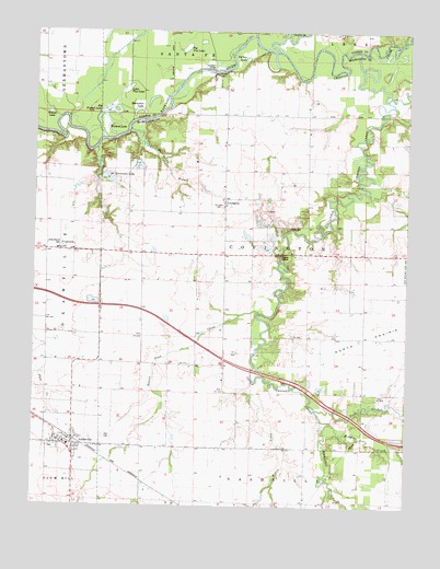
Addieville, IL USGS Topographic Map
Click on map above to begin viewing in our Map Viewer.

This topographic map contains these locations and features:
Feature Name Type Latitude Longitude GNIS ID View Map
AddievillePopulated PlaceN38.3914°W89.4901°403357View Map
Addieville CemeteryCemeteryN38.3903°W89.4867°1967249View Map
Addieville Community Fire Protection DistrictBuildingN38.3916°W89.4868°2640630View Map
Addieville Post OfficePost OfficeN38.3929°W89.4851°2788291View Map
Beaver Pond CreekStreamN38.4248°W89.4251°404067View Map
Big Flat LakeLakeN38.4956°W89.4500°404403View Map
Big Forked LakeLakeN38.4784°W89.4758°404405View Map
Buckingham BranchStreamN38.4742°W89.4687°405130View Map
Carson School (historical)SchoolN38.3762°W89.4084°1823756View Map
Coon CreekStreamN38.4820°W89.3823°406522View Map
CovingtonPopulated PlaceN38.4548°W89.4359°406676View Map
Covington BridgeBridgeN38.4895°W89.4401°424786View Map
Crooked CreekStreamN38.4945°W89.4181°406805View Map
FrogtownPopulated PlaceN38.4423°W89.4918°422715View Map
Going School (historical)SchoolN38.4520°W89.4598°1823764View Map
Grottendick School (historical)SchoolN38.4123°W89.4451°1823766View Map
Hogshead School (historical)SchoolN38.4556°W89.4209°1823771View Map
Horseshoe LakeLakeN38.4794°W89.4655°410568View Map
Little Crooked CreekStreamN38.4948°W89.3917°412323View Map
Little Flat LakeLakeN38.4845°W89.4697°412334View Map
Lively CemeteryCemeteryN38.4489°W89.4140°412447View Map
Lunte CreekStreamN38.3751°W89.4248°412746View Map
Middle CreekStreamN38.3967°W89.4006°413486View Map
Nashville CreekStreamN38.3967°W89.4006°414291View Map
North CreekStreamN38.4006°W89.4054°414584View Map
Olive Branch Lutheran CemeteryCemeteryN38.4428°W89.4920°415083View Map
Olive Branch Lutheran ChurchChurchN38.4423°W89.4915°1985660View Map
RC Kremmers LakeLakeN38.4610°W89.4756°416328View Map
Round LakeLakeN38.4784°W89.4955°416989View Map
Saint Lukes CemeteryCemeteryN38.4537°W89.4370°417517View Map
Township of CovingtonCivilN38.4403°W89.4221°428851View Map
Turkey LakeLakeN38.4927°W89.4298°419936View Map
Village of AddievilleCivilN38.3913°W89.4868°2397910View Map
Wildcat LakeLakeN38.4749°W89.4757°421154View Map
Willow CreekStreamN38.4081°W89.4259°421238View Map
Zion CemeteryCemeteryN38.3931°W89.4762°421629View Map
Zion United Church of ChristChurchN38.3912°W89.4879°1985662View Map

Note: Coordinates in the location and feature list above are referenced to NAD83 datum.


Copyright (C) 2008-2024 Ryan Niemi / Sunset Dynamics ... All Rights Reserved