TopoQuest Logo
Do you find TopoQuest useful?
Help keep TopoQuest running and adding new maps/features by donating!
Bitcoin:  19c7KJd3qBynnjoSw5npx9KScwjBe4ifkT
Litecoin:  LXs6TkuXGGXo1vDsWCkWVdjQX94eUKd6ui
Home View Maps Find Maps Find Places Resources & Links


Mona, Wyoming Topographic Map

USGS Map Title: Mona, WY
USGS Map MRC: 44104G4
DRG (GeoTIFF) Download: o44104g4.tif


Neighboring USGS Topographic Map Quads:


  Gaff Creek, WY  
44104H5
 

  Antelope Gulch, WY  
44104H4
 

  Devils Run, WY  
44104H3
 

  Seely, WY  
44104G5
 

  Mona, WY  
44104G4
 

  Stoney Point, WY  
44104G3
 

  Hulett, WY  
44104F5
 

  Alva, WY  
44104F4
 

  The Notch, WY  
44104F3


Map MRC Location:

N45°
W105°
N45°
W104°
H8 H7 H6 H5 H4 H3 H2 H1
G8 G7 G6 G5 G4 G3 G2 G1
F8 F7 F6 F5 F4 F3 F2 F1
E8 E7 E6 E5 E4 E3 E2 E1
D8 D7 D6 D5 D4 D3 D2 D1
C8 C7 C6 C5 C4 C3 C2 C1
B8 B7 B6 B5 B4 B3 B2 B1
A8 A7 A6 A5 A4 A3 A2 A1
N44°
W105°
N44°
W104°

Mona, WY USGS 1:24K Topographic Map Preview:
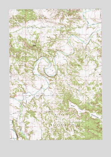
Mona, WY USGS Topographic Map
Click on map above to begin viewing in our Map Viewer.

This topographic map contains these locations and features:
Feature Name Type Latitude Longitude GNIS ID View Map
Arnold CreekStreamN44.8203°W104.4372°1597802View Map
Beaver CreekStreamN44.7878°W104.4863°1598065View Map
Branaman MountainSummitN44.8408°W104.4636°1598357View Map
Brushy CreekStreamN44.8750°W104.3991°1598427View Map
Buffalo BasinBasinN44.8178°W104.3783°1598463View Map
Bunney RanchLocaleN44.8169°W104.3991°1598504View Map
Cross Anchor RanchLocaleN44.8589°W104.4677°1599032View Map
Deer CreekStreamN44.7950°W104.4761°1599203View Map
Deer Creek SchoolSchoolN44.7955°W104.4533°1599208View Map
Driskill DamDamN44.7633°W104.4855°1607302View Map
Driskill ReservoirReservoirN44.7633°W104.4855°1607303View Map
East CreekStreamN44.7967°W104.4522°1599450View Map
Gladson CreekStreamN44.8083°W104.4977°1599951View Map
Harding GulchValleyN44.7889°W104.3941°1600204View Map
Mahoney RanchLocaleN44.7986°W104.4533°1601229View Map
Martin SpringSpringN44.8686°W104.4580°1601275View Map
McClure RanchLocaleN44.8422°W104.4008°1601298View Map
Medicine CreekStreamN44.8608°W104.3941°1601337View Map
MonaPopulated PlaceN44.8100°W104.3813°1601510View Map
Pannell RanchLocaleN44.8117°W104.4600°1602007View Map
Red Arrow DamDamN44.8667°W104.4122°1607632View Map
Red Arrow ReservoirReservoirN44.8667°W104.4122°1607633View Map
Sand DrawValleyN44.8522°W104.3825°1602718View Map
Storm RanchLocaleN44.8572°W104.4411°1603388View Map
Svoboda RanchLocaleN44.8047°W104.4469°1603468View Map
T Cross T RanchLocaleN44.7753°W104.4852°1603503View Map
TerhuneLocaleN44.8075°W104.4880°1603572View Map
Viergutz Three MineMineN44.7686°W104.3986°1726390View Map
Viergutz Two MineMineN44.7686°W104.3986°1726389View Map

Note: Coordinates in the location and feature list above are referenced to NAD83 datum.


Copyright (C) 2008-2024 Ryan Niemi / Sunset Dynamics ... All Rights Reserved