TopoQuest Logo
Do you find TopoQuest useful?
Help keep TopoQuest running and adding new maps/features by donating!
Bitcoin:  19c7KJd3qBynnjoSw5npx9KScwjBe4ifkT
Litecoin:  LXs6TkuXGGXo1vDsWCkWVdjQX94eUKd6ui
Home View Maps Find Maps Find Places Resources & Links


Monroe City, Missouri Topographic Map

USGS Map Title: Monroe City, MO
USGS Map MRC: 39091F6
DRG (GeoTIFF) Download: o39091f6.tif


Neighboring USGS Topographic Map Quads:


  Emden, MO  
39091G7
 

  Philadelphia, MO  
39091G6
 

  Palmyra, MO  
39091G5
 

  Hunnewell, MO  
39091F7
 

  Monroe City, MO  
39091F6
 

  Rensselaer, MO  
39091F5
 

  Stoutsville, MO  
39091E7
 

  Clarence Cannon Dam, MO  
39091E6
 

  Center, MO  
39091E5


Map MRC Location:

N40°
W92°
N40°
W91°
H8 H7 H6 H5 H4 H3 H2 H1
G8 G7 G6 G5 G4 G3 G2 G1
F8 F7 F6 F5 F4 F3 F2 F1
E8 E7 E6 E5 E4 E3 E2 E1
D8 D7 D6 D5 D4 D3 D2 D1
C8 C7 C6 C5 C4 C3 C2 C1
B8 B7 B6 B5 B4 B3 B2 B1
A8 A7 A6 A5 A4 A3 A2 A1
N39°
W92°
N39°
W91°

Monroe City, MO USGS 1:24K Topographic Map Preview:
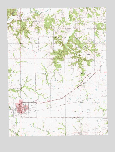
Monroe City, MO USGS Topographic Map
Click on map above to begin viewing in our Map Viewer.

This topographic map contains these locations and features:
Feature Name Type Latitude Longitude GNIS ID View Map
Captain Ben Smith Airfield - Monroe City AirportAirportN39.6352°W91.7281°758819View Map
Cedar CreekStreamN39.7464°W91.7200°715584View Map
City of Monroe CityCivilN39.6542°W91.7327°2395376View Map
Cobb CemeteryCemeteryN39.7395°W91.7293°716053View Map
East Branch Sees CreekStreamN39.7250°W91.6665°717258View Map
Elmslie Memorial State ForestForestN39.7473°W91.7446°737869View Map
ElyPopulated PlaceN39.6917°W91.6332°740832View Map
Ely SchoolSchoolN39.7039°W91.6496°717565View Map
Gottman DamDamN39.7450°W91.7068°760606View Map
Gottman LakeReservoirN39.7450°W91.7068°760607View Map
HassardPopulated PlaceN39.6570°W91.6596°740910View Map
Holy Rosary SchoolSchoolN39.6479°W91.7343°2650313View Map
Middle Branch Sees CreekStreamN39.7106°W91.6754°722267View Map
Monroe CityPopulated PlaceN39.6537°W91.7346°729344View Map
Monroe City Elementary SchoolSchoolN39.6562°W91.7316°2650115View Map
Monroe City Fire DepartmentBuildingN39.6523°W91.7332°2620278View Map
Monroe City High SchoolSchoolN39.6571°W91.7300°2650113View Map
Monroe City Middle SchoolSchoolN39.6568°W91.7318°2650114View Map
Monroe City Police DepartmentBuildingN39.6546°W91.7344°2752458View Map
Monroe City Post OfficePost OfficeN39.6562°W91.7343°2783066View Map
Mount Vernon ChurchChurchN39.7300°W91.6765°732980View Map
Mount Vernon SchoolSchoolN39.7300°W91.6768°722915View Map
North ParkParkN39.6550°W91.7385°723484View Map
Saint Judes CemeteryCemeteryN39.6528°W91.7452°725812View Map
South ParkParkN39.6503°W91.7313°726775View Map
Stone SchoolSchoolN39.7156°W91.7121°727137View Map
Township of WarrenCivilN39.7334°W91.7448°767006View Map
Washington School (historical)SchoolN39.6470°W91.7366°728384View Map
West Branch Sees CreekStreamN39.7250°W91.6665°728535View Map

Note: Coordinates in the location and feature list above are referenced to NAD83 datum.


Copyright (C) 2008-2025 Ryan Niemi / Sunset Dynamics ... All Rights Reserved