TopoQuest Logo
Do you find TopoQuest useful?
Help keep TopoQuest running and adding new maps/features by donating!
Bitcoin:  19c7KJd3qBynnjoSw5npx9KScwjBe4ifkT
Litecoin:  LXs6TkuXGGXo1vDsWCkWVdjQX94eUKd6ui
Home View Maps Find Maps Find Places Resources & Links


Philadelphia, Missouri Topographic Map

USGS Map Title: Philadelphia, MO
USGS Map MRC: 39091G6
DRG (GeoTIFF) Download: o39091g6.tif


Neighboring USGS Topographic Map Quads:


  Nelsonville, MO  
39091H7
 

  Durham, MO  
39091H6
 

  Maywood, MO  
39091H5
 

  Emden, MO  
39091G7
 

  Philadelphia, MO  
39091G6
 

  Palmyra, MO  
39091G5
 

  Hunnewell, MO  
39091F7
 

  Monroe City, MO  
39091F6
 

  Rensselaer, MO  
39091F5


Map MRC Location:

N40°
W92°
N40°
W91°
H8 H7 H6 H5 H4 H3 H2 H1
G8 G7 G6 G5 G4 G3 G2 G1
F8 F7 F6 F5 F4 F3 F2 F1
E8 E7 E6 E5 E4 E3 E2 E1
D8 D7 D6 D5 D4 D3 D2 D1
C8 C7 C6 C5 C4 C3 C2 C1
B8 B7 B6 B5 B4 B3 B2 B1
A8 A7 A6 A5 A4 A3 A2 A1
N39°
W92°
N39°
W91°

Philadelphia, MO USGS 1:24K Topographic Map Preview:
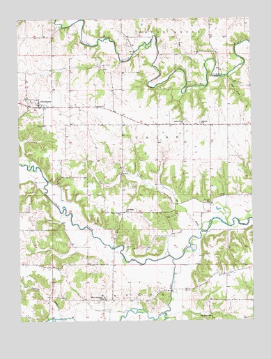
Philadelphia, MO USGS Topographic Map
Click on map above to begin viewing in our Map Viewer.

This topographic map contains these locations and features:
Feature Name Type Latitude Longitude GNIS ID View Map
Bevill AirportAirportN39.8426°W91.7334°758859View Map
Big BranchStreamN39.7909°W91.6474°714139View Map
Camp InlowLocaleN39.8559°W91.7043°715273View Map
Coleman CemeteryCemeteryN39.8306°W91.7368°716109View Map
Crane CemeteryCemeteryN39.7695°W91.6407°716461View Map
Doctor J W Well DamDamN39.8600°W91.7452°760278View Map
Doctor J W Well LakeReservoirN39.8600°W91.7452°760279View Map
Four Corners SchoolSchoolN39.7948°W91.6954°735619View Map
Keller BranchStreamN39.8517°W91.6371°720495View Map
Kempf SchoolSchoolN39.7987°W91.6479°720531View Map
Little UnionPopulated PlaceN39.8309°W91.6543°732954View Map
Little Union ChurchChurchN39.8312°W91.6615°735699View Map
Little Union ChurchyardCemeteryN39.8317°W91.6615°732955View Map
Little Union School (historical)SchoolN39.8306°W91.6624°732961View Map
Marion County R - 2 Fire DepartmentBuildingN39.8390°W91.7404°2621095View Map
NewmarketPopulated PlaceN39.7598°W91.7321°735980View Map
Newmarket BranchStreamN39.7509°W91.7288°723337View Map
Oak Ridge SchoolSchoolN39.7517°W91.6477°735761View Map
Pea Ridge ChurchChurchN39.7953°W91.6929°724127View Map
PhiladelphiaPopulated PlaceN39.8387°W91.7391°724284View Map
Philadelphia CemeteryCemeteryN39.8405°W91.7429°2702450View Map
Philadelphia Post OfficePost OfficeN39.8393°W91.7379°2782762View Map
Pigeon CreekStreamN39.8573°W91.6490°724328View Map
Prairie SchoolSchoolN39.8389°W91.7082°735806View Map
Russel Sandifer DamDamN39.7900°W91.7302°760620View Map
Saint Paul School (historical)SchoolN39.8089°W91.7227°732952View Map
Sandifer LakeReservoirN39.7900°W91.7302°760621View Map
Schmidt SchoolSchoolN39.8314°W91.6518°735842View Map
Sees CreekStreamN39.7525°W91.6738°735846View Map
South Fork North RiverStreamN39.7753°W91.6679°726749View Map
Terrell CemeteryCemeteryN39.8161°W91.7102°727539View Map
Township of UnionCivilN39.8381°W91.7368°767005View Map
Vickrey School (historical)SchoolN39.8603°W91.6715°732953View Map
White Franklin SchoolSchoolN39.7592°W91.7060°728732View Map

Note: Coordinates in the location and feature list above are referenced to NAD83 datum.


Copyright (C) 2008-2025 Ryan Niemi / Sunset Dynamics ... All Rights Reserved