TopoQuest Logo
Do you find TopoQuest useful?
Help keep TopoQuest running and adding new maps/features by donating!
Bitcoin:  19c7KJd3qBynnjoSw5npx9KScwjBe4ifkT
Litecoin:  LXs6TkuXGGXo1vDsWCkWVdjQX94eUKd6ui
Home View Maps Find Maps Find Places Resources & Links


Stoutsville, Missouri Topographic Map

USGS Map Title: Stoutsville, MO
USGS Map MRC: 39091E7
DRG (GeoTIFF) Download: o39091e7.tif


Neighboring USGS Topographic Map Quads:


  Lakenan, MO  
39091F8
 

  Hunnewell, MO  
39091F7
 

  Monroe City, MO  
39091F6
 

  Goss, MO  
39091E8
 

  Stoutsville, MO  
39091E7
 

  Clarence Cannon Dam, MO  
39091E6
 

  Paris East, MO  
39091D8
 

  Florida, MO  
39091D7
 

  Perry, MO  
39091D6


Map MRC Location:

N40°
W92°
N40°
W91°
H8 H7 H6 H5 H4 H3 H2 H1
G8 G7 G6 G5 G4 G3 G2 G1
F8 F7 F6 F5 F4 F3 F2 F1
E8 E7 E6 E5 E4 E3 E2 E1
D8 D7 D6 D5 D4 D3 D2 D1
C8 C7 C6 C5 C4 C3 C2 C1
B8 B7 B6 B5 B4 B3 B2 B1
A8 A7 A6 A5 A4 A3 A2 A1
N39°
W92°
N39°
W91°

Stoutsville, MO USGS 1:24K Topographic Map Preview:
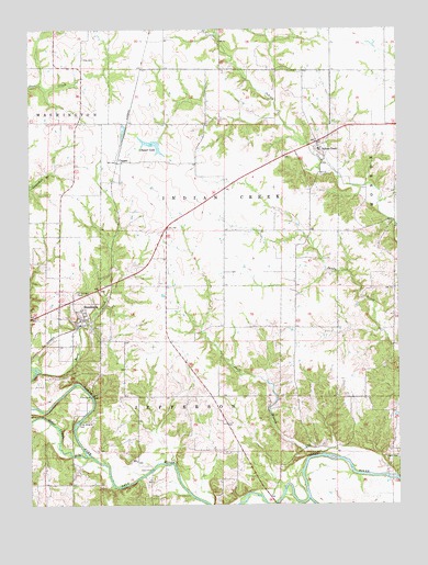
Stoutsville, MO USGS Topographic Map
Click on map above to begin viewing in our Map Viewer.

This topographic map contains these locations and features:
Feature Name Type Latitude Longitude GNIS ID View Map
Buck CreekStreamN39.5350°W91.8716°714956View Map
ClapperPopulated PlaceN39.5900°W91.8452°740745View Map
Clapper LakeReservoirN39.5946°W91.8332°758265View Map
Clapper Lake DamDamN39.5950°W91.8318°761068View Map
Crigler CemeteryCemeteryN39.5125°W91.7505°716500View Map
Fishtrap BridgeBridgeN39.5287°W91.8546°755179View Map
Hays School (historical)SchoolN39.5714°W91.7741°743970View Map
Hickory Grove School (historical)SchoolN39.5289°W91.8149°743971View Map
Hurd School (historical)SchoolN39.5281°W91.7604°743972View Map
Indian CreekPopulated PlaceN39.5945°W91.7768°720106View Map
Jeter CemeteryCemeteryN39.6175°W91.8565°720314View Map
KDAM-FM (Monroe City)TowerN39.5867°W91.7993°759159View Map
Kitty Wheelin FordLocaleN39.5217°W91.8588°720658View Map
Leich FordPopulated PlaceN39.5092°W91.8341°741009View Map
Mark Twain LakeReservoirN39.5009°W91.7762°766204View Map
Middle Fork Salt RiverStreamN39.5020°W91.7807°722278View Map
North Fork Salt RiverStreamN39.5023°W91.7807°723467View Map
Otter CreekStreamN39.5139°W91.8571°735770View Map
Saint Andrews CemeteryCemeteryN39.5559°W91.8596°725720View Map
Shell BranchStreamN39.5134°W91.7763°729391View Map
StoutsvillePopulated PlaceN39.5473°W91.8585°727164View Map
Stoutsville CemeteryCemeteryN39.5467°W91.8516°2702478View Map
Stoutsville Post OfficePost OfficeN39.5511°W91.8656°2783029View Map
Stoutsville Recreation AreaParkN39.5317°W91.8532°736215View Map
Township of Indian CreekCivilN39.5810°W91.8072°767038View Map
Township of MonroeCivilN39.6060°W91.7632°767042View Map
Village of StoutsvilleCivilN39.5479°W91.8573°2399912View Map

Note: Coordinates in the location and feature list above are referenced to NAD83 datum.


Copyright (C) 2008-2024 Ryan Niemi / Sunset Dynamics ... All Rights Reserved