TopoQuest Logo
Do you find TopoQuest useful?
Help keep TopoQuest running and adding new maps/features by donating!
Bitcoin:  19c7KJd3qBynnjoSw5npx9KScwjBe4ifkT
Litecoin:  LXs6TkuXGGXo1vDsWCkWVdjQX94eUKd6ui
Home View Maps Find Maps Find Places Resources & Links


Monticello, New Mexico Topographic Map

USGS Map Title: Monticello, NM
USGS Map MRC: 33107D4
DRG (GeoTIFF) Download: o33107d4.tif


Neighboring USGS Topographic Map Quads:


  Montoya Butte, NM  
33107E5
 

  Vicks Peak, NM  
33107E4
 

  Steel Hill, NM  
33107E3
 

  Jaralosa Mountain, NM  
33107D5
 

  Monticello, NM  
33107D4
 

  Sierra Fijardo, NM  
33107D3
 

  Chise, NM  
33107C5
 

  Priest Tank, NM  
33107C4
 

  Huerfano Hill, NM  
33107C3


Map MRC Location:

N34°
W108°
N34°
W107°
H8 H7 H6 H5 H4 H3 H2 H1
G8 G7 G6 G5 G4 G3 G2 G1
F8 F7 F6 F5 F4 F3 F2 F1
E8 E7 E6 E5 E4 E3 E2 E1
D8 D7 D6 D5 D4 D3 D2 D1
C8 C7 C6 C5 C4 C3 C2 C1
B8 B7 B6 B5 B4 B3 B2 B1
A8 A7 A6 A5 A4 A3 A2 A1
N33°
W108°
N33°
W107°

Monticello, NM USGS 1:24K Topographic Map Preview:
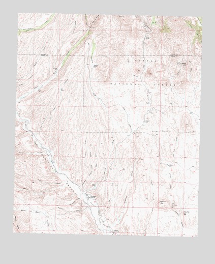
Monticello, NM USGS Topographic Map
Click on map above to begin viewing in our Map Viewer.

This topographic map contains these locations and features:
Feature Name Type Latitude Longitude GNIS ID View Map
Alamo TankReservoirN33.4830°W107.4483°913416View Map
Aragon HillSummitN33.4728°W107.3859°903255View Map
Aragon SpringSpringN33.4738°W107.3897°903257View Map
Aragon WellWellN33.4806°W107.3856°913414View Map
Bar Forty-Four WellWellN33.4506°W107.4103°903545View Map
Bill TankReservoirN33.4568°W107.4707°903828View Map
Calvario DrawValleyN33.3978°W107.4553°904306View Map
Caņada de QuirinoArroyoN33.4220°W107.4773°904383View Map
Caņon de QuirinoValleyN33.4920°W107.4523°904551View Map
Caņon RitaValleyN33.3862°W107.4420°904683View Map
Cedro CanyonValleyN33.4315°W107.4878°904884View Map
Deep CanyonValleyN33.4920°W107.4523°905658View Map
East Monticello SpringSpringN33.4761°W107.3976°913413View Map
Encino DrawValleyN33.4073°W107.4503°906167View Map
Fifty-fifty HillSummitN33.3884°W107.3853°906267View Map
Garcia FallsFallsN33.4924°W107.4523°906475View Map
Garcia Falls SpringSpringN33.4915°W107.4525°937057View Map
Garcia WellWellN33.4681°W107.4728°906486View Map
Goldsborough 1 MineMineN33.4709°W107.3848°940060View Map
Goldsborough 2 MineMineN33.4709°W107.3848°940061View Map
Goldsborough 3 MineMineN33.4709°W107.3848°940062View Map
Goldsborough 4 MineMineN33.4709°W107.3848°940063View Map
Goldsborough DistrictMineN33.4628°W107.4456°917457View Map
Jolla TankReservoirN33.4960°W107.4102°907418View Map
Jose Maria CanyonValleyN33.4162°W107.3967°907447View Map
Jose Maria WellWellN33.4153°W107.3964°907449View Map
Juana CanyonValleyN33.4048°W107.4617°907475View Map
La PetraPopulated PlaceN33.4331°W107.4211°907708View Map
La Questa de TrujilloSummitN33.4931°W107.4134°907713View Map
Las Uvas SpringSpringN33.4781°W107.4258°913412View Map
Lemes CanyonValleyN33.4042°W107.4609°907935View Map
Los Negritos CanyonValleyN33.3940°W107.4536°908218View Map
Lumber TankReservoirN33.4949°W107.3762°913415View Map
Luna Park CampgroundLocaleN33.4959°W107.4153°908322View Map
Middle DrawValleyN33.4106°W107.4475°908690View Map
MonticelloPopulated PlaceN33.3970°W107.4509°908852View Map
Monticello CemeteryCemeteryN33.3923°W107.4528°908854View Map
Monticello Community DitchCanalN33.4287°W107.4884°908855View Map
Monticello Number One TankReservoirN33.4536°W107.3882°913419View Map
Monticello Number Two TankReservoirN33.4370°W107.3761°913418View Map
Monticello Placita Volunteer Fire DepartmentBuildingN33.3965°W107.4505°2658180View Map
Monticello Post OfficePost OfficeN33.3970°W107.4509°937669View Map
Negro DiggingsMineN33.4945°W107.4334°917696View Map
PlacitasPopulated PlaceN33.3773°W107.4331°909751View Map
Placitas CanyonValleyN33.3790°W107.4356°909752View Map
Questa SpringSpringN33.4876°W107.4145°909937View Map
Questa WellWellN33.4876°W107.4142°925803View Map
Red Rock ArroyoValleyN33.4303°W107.4234°910076View Map
Red Rock RanchLocaleN33.4401°W107.4128°910078View Map
RG 24237 Water WellWellN33.4070°W107.4692°925814View Map
RG 24355C Water WellWellN33.4315°W107.4870°921997View Map
RG 27650 Water WellWellN33.3965°W107.4528°925813View Map
RG 31106 Water WellWellN33.4090°W107.4717°925816View Map
Saint Ignatius ChurchChurchN33.3962°W107.4495°910524View Map
Saint Lorenzo ChurchChurchN33.3767°W107.4325°910531View Map
Sanchez CanyonValleyN33.4006°W107.4550°2025930View Map
Seferino CanyonValleyN33.3976°W107.3953°910931View Map
Seferino HillSummitN33.3942°W107.4014°910932View Map
Shipman WellWellN33.4901°W107.4953°911019View Map
Stanley SpringSpringN33.4704°W107.4489°911387View Map
Stanley TankReservoirN33.4530°W107.4427°913417View Map
Stanley WellReservoirN33.4473°W107.4398°937060View Map
Sullivan CanyonValleyN33.3915°W107.4495°911472View Map
Tank DrawValleyN33.4106°W107.4475°911539View Map
Terry ProspectMineN33.4126°W107.4273°917932View Map
Uvas CanyonValleyN33.4626°W107.4139°912016View Map
Wilhite WellWellN33.4562°W107.4856°912387View Map

Note: Coordinates in the location and feature list above are referenced to NAD83 datum.


Copyright (C) 2008-2024 Ryan Niemi / Sunset Dynamics ... All Rights Reserved