TopoQuest Logo
Do you find TopoQuest useful?
Help keep TopoQuest running and adding new maps/features by donating!
Bitcoin:  19c7KJd3qBynnjoSw5npx9KScwjBe4ifkT
Litecoin:  LXs6TkuXGGXo1vDsWCkWVdjQX94eUKd6ui
Home View Maps Find Maps Find Places Resources & Links


Monticello North, Arkansas Topographic Map

USGS Map Title: Monticello North, AR
USGS Map MRC: 33091F7
DRG (GeoTIFF) Download: o33091f7.tif


Neighboring USGS Topographic Map Quads:


  Cornerville, AR  
33091G8
 

  Relfs Bluff, AR  
33091G7
 

  Tyro, AR  
33091G6
 

  Wilmar North, AR  
33091F8
 

  Monticello North, AR  
33091F7
 

  Collins NW, AR  
33091F6
 

  Wilmar South, AR  
33091E8
 

  Monticello South, AR  
33091E7
 

  Cominto, AR  
33091E6


Map MRC Location:

N34°
W92°
N34°
W91°
H8 H7 H6 H5 H4 H3 H2 H1
G8 G7 G6 G5 G4 G3 G2 G1
F8 F7 F6 F5 F4 F3 F2 F1
E8 E7 E6 E5 E4 E3 E2 E1
D8 D7 D6 D5 D4 D3 D2 D1
C8 C7 C6 C5 C4 C3 C2 C1
B8 B7 B6 B5 B4 B3 B2 B1
A8 A7 A6 A5 A4 A3 A2 A1
N33°
W92°
N33°
W91°

Monticello North, AR USGS 1:24K Topographic Map Preview:
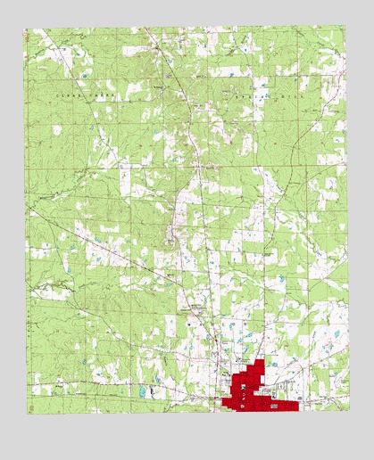
Monticello North, AR USGS Topographic Map
Click on map above to begin viewing in our Map Viewer.

This topographic map contains these locations and features:
Feature Name Type Latitude Longitude GNIS ID View Map
Ballast JunctionLocaleN33.6279°W91.7585°78962View Map
City of MonticelloCivilN33.6254°W91.7935°2404290View Map
Drew County CourthouseBuildingN33.6268°W91.7918°79014View Map
Drew County Sheriff's OfficeBuildingN33.6269°W91.7916°2118711View Map
Dura Craft LakeReservoirN33.6320°W91.8304°80471View Map
Dura Craft Lake DamDamN33.6301°W91.8301°80470View Map
East End ChurchChurchN33.6284°W91.7582°48758View Map
Fauline ChurchChurchN33.6368°W91.7965°49011View Map
Gaster HillSummitN33.6576°W91.8121°57801View Map
Lawson CemeteryCemeteryN33.6593°W91.8112°77461View Map
MonticelloPopulated PlaceN33.6290°W91.7910°52144View Map
Monticello Ambulance ServiceBuildingN33.6275°W91.7955°2119037View Map
Monticello Fire Department Station 1BuildingN33.6288°W91.7919°2116804View Map
Monticello Municipal Airport/Ellis FieldAirportN33.6351°W91.7552°83781View Map
Monticello North Main Historic DistrictParkN33.6323°W91.7904°70294View Map
Monticello North Man Historic DistrictParkN33.6323°W91.7904°79041View Map
Monticello Police DepartmentBuildingN33.6288°W91.7920°2118712View Map
Monticello Post OfficePost OfficeN33.6480°W91.7999°84774View Map
MontongoPopulated PlaceN33.7432°W91.8224°79042View Map
Mount Pleasant CemeteryCemeteryN33.7293°W91.8221°79048View Map
Mount Pleasant ChurchChurchN33.7296°W91.8215°52396View Map
Oak Grove ChurchChurchN33.6343°W91.7746°52897View Map
Oakland CemeteryCemeteryN33.6353°W91.7970°52952View Map
Pauline Missionary Baptist ChurchChurchN33.6371°W91.7965°79068View Map
Rose HillPopulated PlaceN33.6659°W91.8143°79102View Map
Rose Hill CemeteryCemeteryN33.6751°W91.7829°79084View Map
Rose Hill ChurchChurchN33.6693°W91.8207°54203View Map
Rose Hill ChurchChurchN33.6759°W91.7829°54204View Map
Rose Hill School (historical)SchoolN33.6687°W91.8201°79085View Map
Saint Mary African Methodist Episcopal ChurchChurchN33.6337°W91.8615°78253View Map
Southeast Emergency Medical ServiceBuildingN33.6288°W91.7961°2119036View Map
TennesseePopulated PlaceN33.6312°W91.8487°79098View Map
Whaley SchoolSchoolN33.6326°W91.7910°78741View Map

Note: Coordinates in the location and feature list above are referenced to NAD83 datum.


Copyright (C) 2008-2025 Ryan Niemi / Sunset Dynamics ... All Rights Reserved