TopoQuest Logo
Do you find TopoQuest useful?
Help keep TopoQuest running and adding new maps/features by donating!
Bitcoin:  19c7KJd3qBynnjoSw5npx9KScwjBe4ifkT
Litecoin:  LXs6TkuXGGXo1vDsWCkWVdjQX94eUKd6ui
Home View Maps Find Maps Find Places Resources & Links


Montrose, Arkansas Topographic Map

USGS Map Title: Montrose, AR
USGS Map MRC: 33091C4
DRG (GeoTIFF) Download: o33091c4.tif


Neighboring USGS Topographic Map Quads:


  Line, AR  
33091D5
 

  Jerome, AR  
33091D4
 

  Macon Lake, AR  
33091D3
 

  Snyder, AR  
33091C5
 

  Montrose, AR  
33091C4
 

  Lake Village, AR  
33091C3
 

  Portland, AR  
33091B5
 

  Eudora NW, AR  
33091B4
 

  Eudora North, AR  
33091B3


Map MRC Location:

N34°
W92°
N34°
W91°
H8 H7 H6 H5 H4 H3 H2 H1
G8 G7 G6 G5 G4 G3 G2 G1
F8 F7 F6 F5 F4 F3 F2 F1
E8 E7 E6 E5 E4 E3 E2 E1
D8 D7 D6 D5 D4 D3 D2 D1
C8 C7 C6 C5 C4 C3 C2 C1
B8 B7 B6 B5 B4 B3 B2 B1
A8 A7 A6 A5 A4 A3 A2 A1
N33°
W92°
N33°
W91°

Montrose, AR USGS 1:24K Topographic Map Preview:
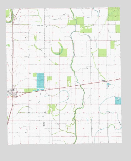
Montrose, AR USGS Topographic Map
Click on map above to begin viewing in our Map Viewer.

This topographic map contains these locations and features:
Feature Name Type Latitude Longitude GNIS ID View Map
Bear BayouGutN33.3593°W91.4493°46191View Map
BoydellPopulated PlaceN33.3657°W91.4912°76407View Map
Central ChurchChurchN33.3037°W91.4268°47654View Map
City of MontroseCivilN33.2985°W91.4968°2404294View Map
CosgrovePopulated PlaceN33.3065°W91.3996°57585View Map
Dry BayouStreamN33.2585°W91.4251°48621View Map
Evergreen CemeteryCemeteryN33.3748°W91.4932°62366View Map
Evergreen ChurchChurchN33.3743°W91.4932°48949View Map
Lighterwood BayouStreamN33.3651°W91.4257°51162View Map
Lost LakeStreamN33.3532°W91.4248°51473View Map
MontrosePopulated PlaceN33.2976°W91.4937°58209View Map
Montrose Fire Department Station 78BuildingN33.2976°W91.4926°2116806View Map
Montrose Police DepartmentBuildingN33.2976°W91.4925°2118699View Map
Montrose Post OfficePost OfficeN33.2970°W91.4932°84149View Map
New Bethel ChurchChurchN33.3068°W91.3912°52619View Map
New Liberty ChurchChurchN33.2710°W91.4562°52711View Map
Shady Grove CemeteryCemeteryN33.3309°W91.4751°62362View Map
Shady Grove ChurchChurchN33.3307°W91.4748°54701View Map
Township of Gaines (historical)CivilN33.3001°W91.4251°70000View Map
Township of UnionCivilN33.3595°W91.4997°63684View Map
Union CemeteryCemeteryN33.3312°W91.4940°62363View Map
Union ChurchChurchN33.3312°W91.4937°55793View Map
Wards BayouStreamN33.2787°W91.4257°56053View Map

Note: Coordinates in the location and feature list above are referenced to NAD83 datum.


Copyright (C) 2008-2025 Ryan Niemi / Sunset Dynamics ... All Rights Reserved