TopoQuest Logo
Do you find TopoQuest useful?
Help keep TopoQuest running and adding new maps/features by donating!
Bitcoin:  19c7KJd3qBynnjoSw5npx9KScwjBe4ifkT
Litecoin:  LXs6TkuXGGXo1vDsWCkWVdjQX94eUKd6ui
Home View Maps Find Maps Find Places Resources & Links


Lake Village, Arkansas Topographic Map

USGS Map Title: Lake Village, AR
USGS Map MRC: 33091C3
DRG (GeoTIFF) Download: o33091c3.tif


Neighboring USGS Topographic Map Quads:


  Jerome, AR  
33091D4
 

  Macon Lake, AR  
33091D3
 

  Luna, AR  
33091D2
 

  Montrose, AR  
33091C4
 

  Lake Village, AR  
33091C3
 

  Red Leaf, AR  
33091C2
 

  Eudora NW, AR  
33091B4
 

  Eudora North, AR  
33091B3
 

  Eminence, AR  
33091B2


Map MRC Location:

N34°
W92°
N34°
W91°
H8 H7 H6 H5 H4 H3 H2 H1
G8 G7 G6 G5 G4 G3 G2 G1
F8 F7 F6 F5 F4 F3 F2 F1
E8 E7 E6 E5 E4 E3 E2 E1
D8 D7 D6 D5 D4 D3 D2 D1
C8 C7 C6 C5 C4 C3 C2 C1
B8 B7 B6 B5 B4 B3 B2 B1
A8 A7 A6 A5 A4 A3 A2 A1
N33°
W92°
N33°
W91°

Lake Village, AR USGS 1:24K Topographic Map Preview:
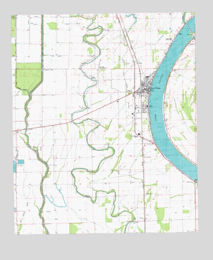
Lake Village, AR USGS Topographic Map
Click on map above to begin viewing in our Map Viewer.

This topographic map contains these locations and features:
Feature Name Type Latitude Longitude GNIS ID View Map
AshtonPopulated PlaceN33.3129°W91.3393°76206View Map
Bayou Macon (historical)Populated PlaceN33.3182°W91.3240°61730View Map
Bayou Macon CemeteryCemeteryN33.3507°W91.3193°61732View Map
Bayou Macon ChurchChurchN33.3507°W91.3190°46176View Map
Central Elementary SchoolSchoolN33.3387°W91.2832°61739View Map
Central Middle SchoolSchoolN33.3218°W91.2865°61737View Map
ChanticleerPopulated PlaceN33.3010°W91.2793°61733View Map
Chicot CountyCivilN33.2673°W91.2940°69160View Map
Chicot County Sheriff's OfficeBuildingN33.3314°W91.2852°2118701View Map
Chicot Memorial Hospital HeliportAirportN33.3068°W91.2901°83744View Map
Chicot Memorial Medical CenterHospitalN33.3061°W91.2894°61735View Map
City of Lake VillageCivilN33.3290°W91.2852°2404868View Map
Crooked Bayou ChurchChurchN33.2929°W91.3732°48166View Map
Davies CemeteryCemeteryN33.3427°W91.2652°48372View Map
Elite Medical Service Chicot CountyBuildingN33.3120°W91.2916°2119031View Map
FairviewPopulated PlaceN33.2837°W91.2607°57739View Map
Forrest Aid ChurchChurchN33.3032°W91.3259°49177View Map
Greenland CemeteryCemeteryN33.3568°W91.2549°49659View Map
Greenland ChurchChurchN33.3576°W91.2546°49660View Map
JenniePopulated PlaceN33.2562°W91.2862°57987View Map
Jennie CemeteryCemeteryN33.2584°W91.2929°61728View Map
Jennie ChurchChurchN33.2590°W91.2932°50621View Map
Lake ChicotLakeN33.2850°W91.2545°74738View Map
Lake Chicot Dam NorthDamN33.3668°W91.2551°80768View Map
Lake VillagePopulated PlaceN33.3287°W91.2818°58036View Map
Lake Village County ClubLocaleN33.3596°W91.2659°61741View Map
Lake Village Municipal AirportAirportN33.3425°W91.3157°83743View Map
Lake Village Police DepartmentBuildingN33.3312°W91.2848°2118700View Map
Lake Village Volunteer Fire Department Station 2BuildingN33.3103°W91.2919°2116690View Map
Lake Village Volunteer Fire Station 1BuildingN33.3319°W91.2837°2116691View Map
LakehallPopulated PlaceN33.3285°W91.2707°77436View Map
Lakeside High SchoolSchoolN33.3252°W91.3104°61738View Map
Lakeside Lower Elementary SchoolSchoolN33.3239°W91.3139°2039356View Map
Lakeside Middle SchoolSchoolN33.3246°W91.3123°2039358View Map
Lakeside Upper Elementary SchoolSchoolN33.3243°W91.3131°2039357View Map
Liberty CemeteryCemeteryN33.3140°W91.2715°61736View Map
Liberty ChurchChurchN33.3129°W91.2712°51097View Map
Little Lake BayouGutN33.3401°W91.2993°51294View Map
Mount Zion CemeteryCemeteryN33.3654°W91.3190°52440View Map
Mount Zion ChurchChurchN33.3659°W91.3176°52455View Map
Myrtle GrovePopulated PlaceN33.3104°W91.2712°58236View Map
Old Boeuf RiverStreamN33.3304°W91.3637°46790View Map
Paps SloughGutN33.2912°W91.3043°53171View Map
Pleasant Hope CemeteryCemeteryN33.2704°W91.2862°61729View Map
Pleasant Hope ChurchChurchN33.2718°W91.2857°53581View Map
Reeves (historical)Populated PlaceN33.3107°W91.3601°61726View Map
Saint John CemeteryCemeteryN33.2562°W91.2940°61727View Map
Saint John ChurchChurchN33.2557°W91.2943°54348View Map
Saint Luke CemeteryCemeteryN33.3584°W91.2932°61740View Map
Saint Luke ChurchChurchN33.3582°W91.2934°54382View Map
Smith ChapelChurchN33.2840°W91.3218°54940View Map
Southeast Rehabilitation HospitalHospitalN33.3063°W91.2891°2733214View Map
Township of CarltonCivilN33.3403°W91.2950°68718View Map
Westside ChurchChurchN33.3462°W91.2976°61731View Map
Whiskey Chute DamDamN33.3618°W91.2518°81270View Map
Woodson TempleChurchN33.3051°W91.2882°78807View Map
Woodson Temple CemeteryCemeteryN33.3029°W91.2862°61734View Map

Note: Coordinates in the location and feature list above are referenced to NAD83 datum.


Copyright (C) 2008-2024 Ryan Niemi / Sunset Dynamics ... All Rights Reserved